2GIS: yesterday, today, tomorrow
In the 90s, most of the cards people used were large and papery. Electronic GIS (geographic information systems) already existed, but in the dungeons of scientific research institutes they were made by professionals for their own purposes.
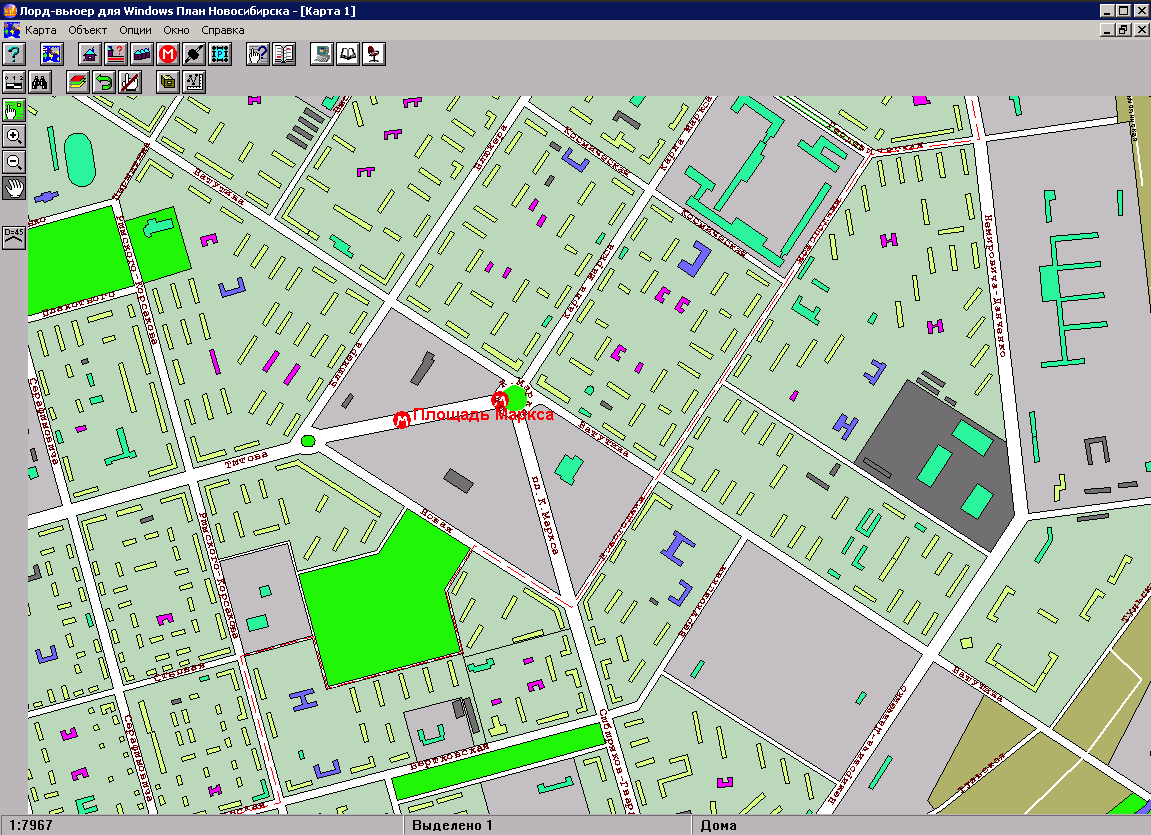
A little later, computers became more or less accessible, ceasing to be something elite or purely scientific. Began to appear and the program "for all". So, in 1999 a “Plan-scheme of Novosibirsk” appeared. It was an electronic map based on the professional Lordview GIS. Perhaps the first of its kind, with a target audience among ordinary users.
Interface and usability ... corresponded to the time of release of the program.
')
How 2GIS changed and what will happen tomorrow, you can find out under the cut.
Based on the same Lordview, the reference book "Construction Companies of Novosibirsk" is published. Even later, this resulted in the concept of a map of the city, combined with a directory of organizations.
Actually, the name 2GIS: geographic information system plus city information directory.
First, the program was sold on CD, and, of course, it was pirated by all and sundry. But the way out was found. Obvious today, but brave enough for the realities of those days - to make the program completely free and earn something else. Something else was advertising in the directory - this model works in 2GIS to this day.
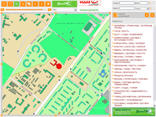
This is how DoubleGIS 2.0 appeared. Besides the fact that it could now be downloaded for free from the site, it changed visually. A more attractive and convenient (for that time) interface was made, information on public transport was added, and a green card that many people remember.

In the courtyard of the middle of the two thousandth. The peculiar sounds of dial-up connections are supplanted by fast, dedicated Internet access. We release the online version of DoubleGIS. From that moment, it became possible to select the desired company or find something on the map from any computer that is simply connected to the network. In the spirit of time, the map was drawn on the fly, which caused some nuances with performance. 40 people could use Online at the same time. In future versions, this problem was solved using pre-generated tiles.
The further development of 2GIS went along the path of simplifying UX and improving design.
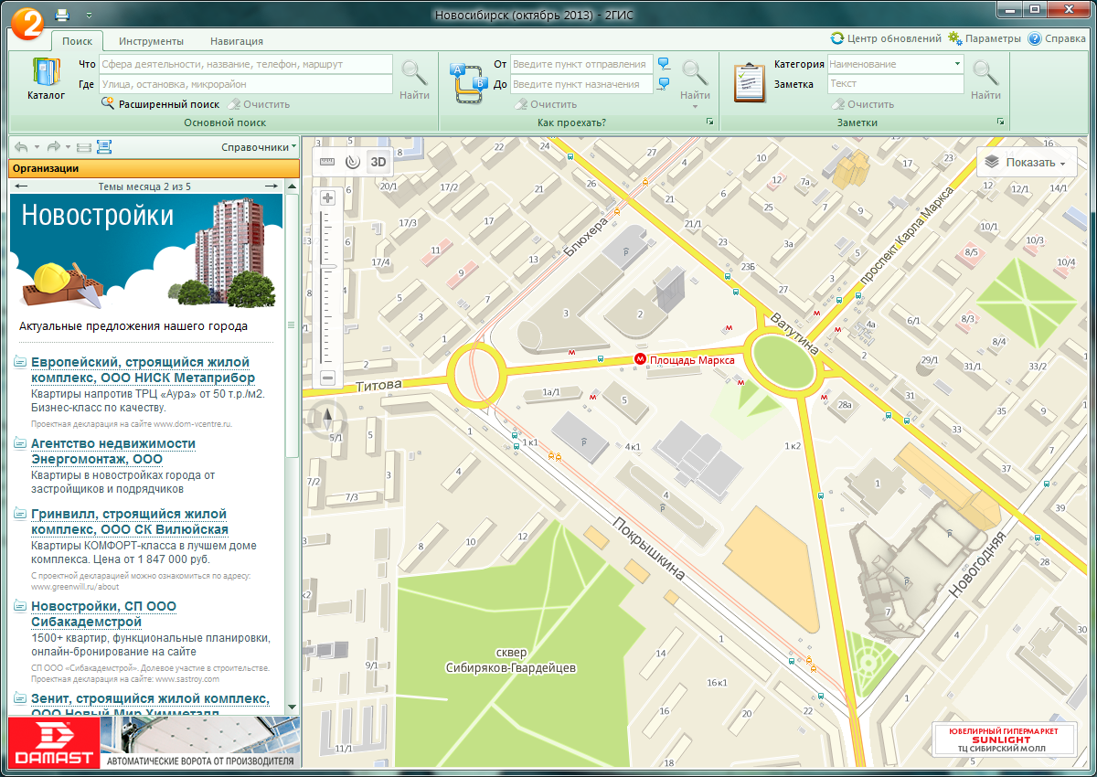
DoubleGIS 3.0 was designed to simplify the handling of the program. The step controversial at that time was the introduction of a ribbon-bar, as in the recently released Office 2007. Of course, the first reaction of users was negative, we were asked to “return everything as it was”. But over time, the criticism faded away and everyone appreciated the convenience.

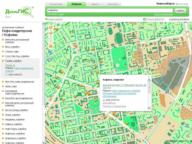
In parallel, we developed 2GIS Online, version 2.0 was released. The product has become faster and got rid of visual noise.
And then, almost simultaneously, three key events take place: DoubleGIS turns into 2GIS, comes to Moscow and says goodbye to a kind of green card that has become native to many.
In Moscow, 2GIS immediately went out in beige tones. In other cities, the process of abandoning the green card began with 2GIS Online, which, meanwhile, has evolved to version 3.0.
A single color change was not enough. A cardinal card design was required, since the available ones did not meet modern requirements. It was time to drop the existing and start all over again. A bold but necessary decision.
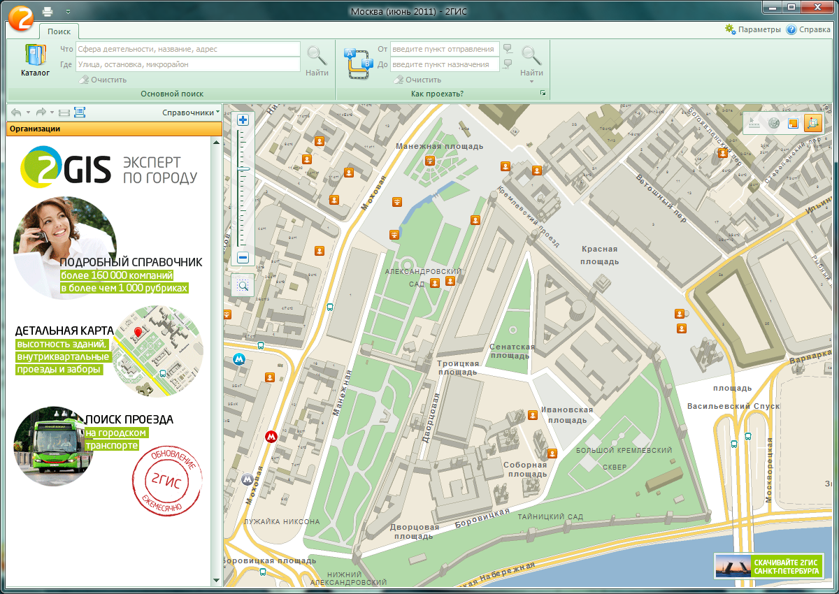
As a result, in the spring of 2012, new maps appeared in 2GIS products. Of course, not without a reaction in the spirit of "Durov, return the wall." But people are conservative and we were ready for this.
We redrawn everything that could be redrawn, replaced the fonts and made a full-fledged 2GIS 3D PC engine, supporting it with 3D models of the most famous buildings.
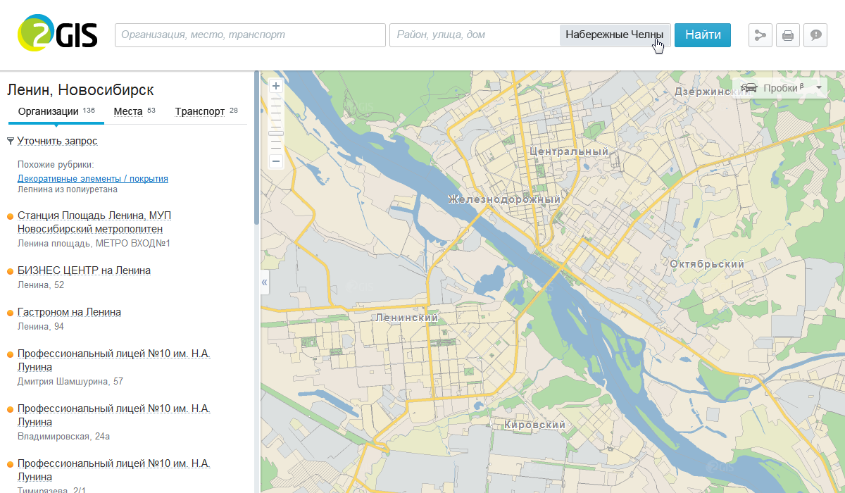
But there is no limit to perfection. There is always something that can be improved. And we are constantly working on it. We have already introduced some of the upcoming improvements: cool blue pins markers.
Of course, this is not all that we have been working on lately. Tomorrow in Digital October there will be an exciting event for us. On it we will show the new 2GIS and the latest developments of the company.
If you want to come to visit, write to Maxim . Tell us in a letter who you are, what you do and why you are interested in visiting the event.
For those who can not get, but there is a desire to learn about new products - you can watch the broadcast on the Digitaloctober website or here on Habré. We are waiting for you in our next post.
A little later, computers became more or less accessible, ceasing to be something elite or purely scientific. Began to appear and the program "for all". So, in 1999 a “Plan-scheme of Novosibirsk” appeared. It was an electronic map based on the professional Lordview GIS. Perhaps the first of its kind, with a target audience among ordinary users.
Interface and usability ... corresponded to the time of release of the program.
')
How 2GIS changed and what will happen tomorrow, you can find out under the cut.
Long
Based on the same Lordview, the reference book "Construction Companies of Novosibirsk" is published. Even later, this resulted in the concept of a map of the city, combined with a directory of organizations.
Actually, the name 2GIS: geographic information system plus city information directory.
First, the program was sold on CD, and, of course, it was pirated by all and sundry. But the way out was found. Obvious today, but brave enough for the realities of those days - to make the program completely free and earn something else. Something else was advertising in the directory - this model works in 2GIS to this day.
This is how DoubleGIS 2.0 appeared. Besides the fact that it could now be downloaded for free from the site, it changed visually. A more attractive and convenient (for that time) interface was made, information on public transport was added, and a green card that many people remember.
Yesterday
In the courtyard of the middle of the two thousandth. The peculiar sounds of dial-up connections are supplanted by fast, dedicated Internet access. We release the online version of DoubleGIS. From that moment, it became possible to select the desired company or find something on the map from any computer that is simply connected to the network. In the spirit of time, the map was drawn on the fly, which caused some nuances with performance. 40 people could use Online at the same time. In future versions, this problem was solved using pre-generated tiles.
The further development of 2GIS went along the path of simplifying UX and improving design.
DoubleGIS 3.0 was designed to simplify the handling of the program. The step controversial at that time was the introduction of a ribbon-bar, as in the recently released Office 2007. Of course, the first reaction of users was negative, we were asked to “return everything as it was”. But over time, the criticism faded away and everyone appreciated the convenience.
In parallel, we developed 2GIS Online, version 2.0 was released. The product has become faster and got rid of visual noise.
And then, almost simultaneously, three key events take place: DoubleGIS turns into 2GIS, comes to Moscow and says goodbye to a kind of green card that has become native to many.
In Moscow, 2GIS immediately went out in beige tones. In other cities, the process of abandoning the green card began with 2GIS Online, which, meanwhile, has evolved to version 3.0.
Today
A single color change was not enough. A cardinal card design was required, since the available ones did not meet modern requirements. It was time to drop the existing and start all over again. A bold but necessary decision.
As a result, in the spring of 2012, new maps appeared in 2GIS products. Of course, not without a reaction in the spirit of "Durov, return the wall." But people are conservative and we were ready for this.
We redrawn everything that could be redrawn, replaced the fonts and made a full-fledged 2GIS 3D PC engine, supporting it with 3D models of the most famous buildings.
But there is no limit to perfection. There is always something that can be improved. And we are constantly working on it. We have already introduced some of the upcoming improvements: cool blue pins markers.
Tomorrow
Of course, this is not all that we have been working on lately. Tomorrow in Digital October there will be an exciting event for us. On it we will show the new 2GIS and the latest developments of the company.
If you want to come to visit, write to Maxim . Tell us in a letter who you are, what you do and why you are interested in visiting the event.
For those who can not get, but there is a desire to learn about new products - you can watch the broadcast on the Digitaloctober website or here on Habré. We are waiting for you in our next post.
Source: https://habr.com/ru/post/202496/
All Articles