Intergeo 2013. Essen. Germany. Laser scan
Hello, dear Habrasoobschestvo.
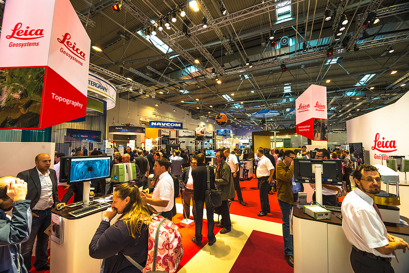
The event, about some aspects of which I would like to tell you, can be attributed to the very well-known in narrow circles. Let me say a few words about what Intergeo is .
This is an exhibition of geodesic-cartographic achievements, which has been annually presented in Germany for more than 20 years. There is simply no larger event that would affect such areas as geodesy, cartography, photogrammetry, GIS and spatial modeling. There are major leadership seminars, but they are usually based around a single brand (for example, ESRI).
')
That is why at Intergeo you can evaluate the current development of many areas, see the latest developments, find direct contacts with manufacturers. Participation of the company at this exhibition can be directly evaluated as positioning thereof in the world market.
Initially, I planned to make a post-review of all the directions presented at the exhibition, but after reviewing the materials collected at the exhibition, I realized that for this I would need several weeks, I now have such diverse information. Therefore, in this post we will talk only about one, young and promising direction, which has recently gained such momentum that it is impossible not to pay attention to it. I propose to discuss the current state of laser scanning (with a slight bias in 3D modeling).
Separately, I want to indicate that the following aspects of the exhibition interested me primarily as a surveyor.
Let's start with a little insight into history, albeit not too far away. The development of digital geodetic technology, in particular laser range finders, quite predictably led to the first attempts at collecting a laser scanner. The first mentions of such devices belong to the mid-90s. For example, Cyberware company released in 1991 a device capable of scanning small objects, it was supposed to use these scanners in medicine. For geodesy, these devices are not suitable, but the principles have already been defined.
The first geodesic scanners under the brand Cyrax model 2400 in 1998, about the same time came RIEGL Scanner LMS Z 210. Cyrax three years later was bought by Leica, but Riegl still exists on the market as an independent manufacturer.
In a few words I will describe what the laser scanner does and why it is needed. In essence, the scanner, like the total station, is a goniometer with a laser rangefinder. The only difference is that the scanner performs a very large number of measurements per unit of time, rotating the measurement plane around its axis. Scanning, thus, the space around it.
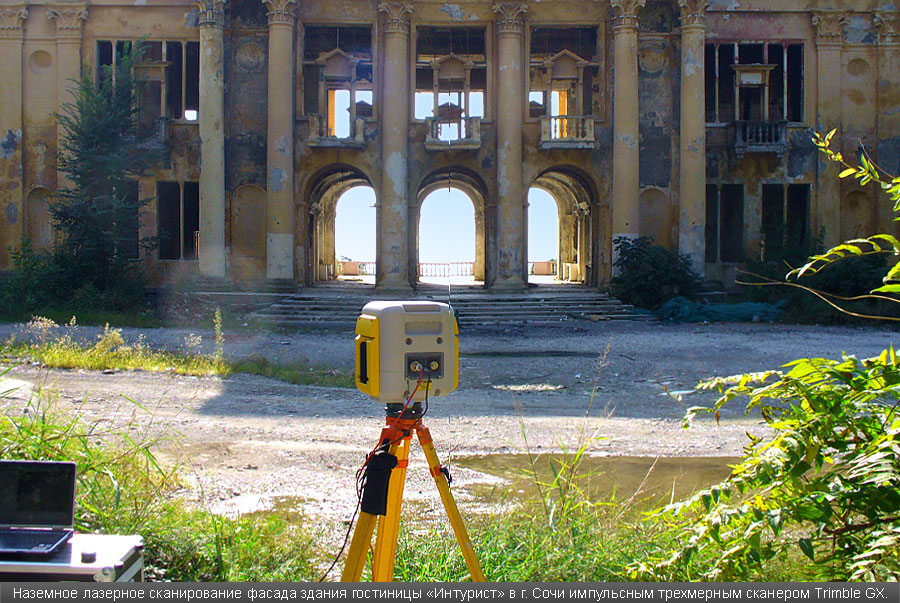
Trimble GX laser scanner in front of the scanned building. Taken with Navgek Engineering
At the exit, we have a “scan” - a cloud of points, which is characterized by low discreteness, and under certain conditions can be perceived as continuous. Why it is needed. If we have an object with complex outlines (for example, an industrial installation, or a facade of a historic building, etc.), then it is very difficult to reproduce its mathematically exact image with traditional geodetic tools. The scanner is faster and easier (but not always).
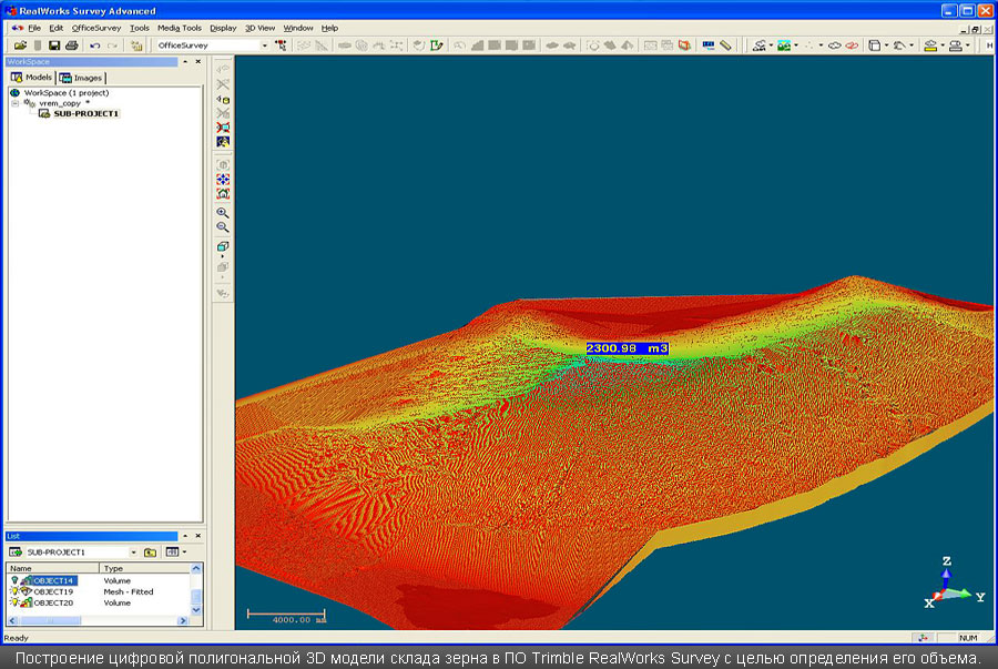
Cloud point Taken with Navgek Engineering
From the outset, laser scanning competed with photogrammetric photography, which allows you to do almost the same thing, but with a sufficient number of additional conditions. But it is cheaper. It was in any case. Bye scan wins.
What usually scan? The architecture - especially the ancient facades, industrial enterprises with a bunch of pipes, transitions, etc., volumes - tanks, plugs, interior spaces. In surveying and cabling scanners, rather, are useless.
Naturally, this technology has not passed by the active players. All leaders of the geodesic market zealously set about developing (or buying) technologies. At the moment, only Javad did not boast of its scanning solution (because it is fully focused on GPS). Leica, Trimble, Topcon produce scanners. Along with them are Z + F, Riegl, Faro - specialized manufacturers exclusively scanners. Once, even UOMZ intended to launch a scanner and even cut a prototype out of plywood, but somehow it didn’t work out further. The mention is on the omniscient "surveyor . " Although the Russian Surphaser scanner exists.
At this stage, the following segments can be distinguished in laser scanning: ground laser scanning and mobile laser scanning.
As for the ground part - this is the main niche of laser scanners. The main competition is for technical specifications - who are farther, denser and more accurate can create a cloud of points. Well, faster, of course. Everyone participates in the competition. Another tendency is to reduce the size of the scanner, here, the leader is Faro, whose scanner is no larger than a toaster.
The latest trend is to embed a controller screen into the scanner body itself, from which control operations can be conducted. The monitor is small, but now the scanner control software from the laptop can be sold separately (for example, Leica and their Cyclone). Such scanners already have Leica P20, Trimble TX5, TopCon. The latter, however, presented a scanner at the exhibition, for which so far there is no information at all, there is no model. Attempts by the internal controller to create a scanning zone were stopped by the manager with the phrase “this function is in the scanner, but there are no menu items for it”.

Z + F scanner with side screen controller.
Consider the Leica P20 scanner, as the most typical representative of the segment. The distance is 120 meters (quite a lot for a phase scanner), accuracy 3 mm by 50 m, 6 mm by 100 m. Able to scan with a resolution of 0.8 mm at a distance of 10 m, while the time for scanning will take about 1.5 hours. 12 kg weigh, sizes 24 * 35 * 40 cm.
Leica P20 scanner. Image taken from here.
There is one more parameter for these devices, which, unfortunately, it is impossible to objectively estimate - it is susceptibility to the influence of the external environment. None of the manufacturers do not provide statistics on equipment failures. In other cases, this is the main determining criterion. Often, firms that are actively conducting work on laser scanning immediately acquire 2 scanners, knowing that after the first projects, some of them will go to the service. In addition, it is impossible to determine the viability of a particular model by word of mouth. Leica P20, by chance, "tenacious." The manufacturer has assigned it a class IP54 and temperature operation from -20 to +50. 5 years ago, such parameters were a fairy tale, and in winter, scanners wore covers with thermochemical heating elements.
Surprise in this segment was outwardly modest scanner Hi-Target. It is not remarkable, except that it is the first independent Chinese scanner. How it works is a big question. But this is the first sign from Asian friends, so they try themselves in the geodesic Hi-End. As for the Low-End, then, involuntarily, after the exhibition, the impression is born that only the laziest Chinese did not solder a two-system geodetic GPS receiver and did not assemble a digital total station. It is the turn of scanners.

The first Chinese scanner Hi-Target
Mobile laser scanning is a trend of recent years. Similar decisions have been encountered before, but perhaps only this exhibition showed that all the leaders of the geodetic market rushed into this niche.
Each of the leaders demonstrated similar systems on different media. Leica, Trimble, Topcon, Riegl, Faro placed laser scanners on cars. The devices are very similar in parameters, so let's turn to the Trimble MX2 mobile laser scanner featured on the Mini's roof.
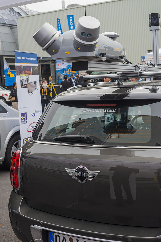
Trimble MX2 Mini Roof Scanner
Of course, the first thing that interests is accuracy. This device claimed 10 mm to 50 meters. Such accuracy is achieved due to the installed inertial system together with 2 satellite antennas, the accuracy of which during the post-processing is declared in the range from 2 to 5 mm. 360 degree visibility. The range is 250 m, but most likely at this distance the accuracy will drop to 5 cm.
The second thing that interests you is how fast can you scan? Trimble does not have this information directly, so you have to access Leica data with their HDS7000 scanner embedded in the Pegasus: One photo system. Most likely, it is necessary to limit 40 km / h. According to representatives on the stand, the speed can be maintained and high (for example, when shooting highways), but then the cloud is sparse, and the output can be found in repeated passage of the scanner on the highway.
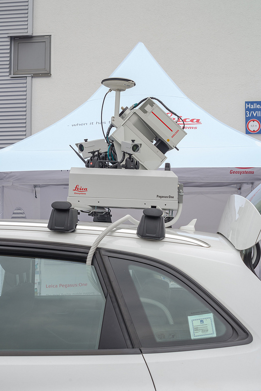
HDS700 Leica Scanner
Probably worth mentioning the cost of these devices. A laser scanner is far from a cheap tool and when buying such a ground-based device you should count on the price starting from 80,000 Euro. As for the mobile solution, when buying an "all inclusive" issue price increases by about 4-5 times. The exact price in Russia for new devices will not be clearly told by anyone, only an approximate order.
Separately, I want to mention 2 derivative solutions The first is the Faro scanner (the one with the toaster size) mounted in a quadcopter.

Flying Faro Scanner
The manufacturer positions it as an ideal solution for architectural photography, accuracy up to 10 mm. The bottom line is that the points that determine the contours of the building are taken with a tachometer, and then the route for the scanner to fly is laid in the quadcopter controller. How is it fundamentally better than ground shooting - guaranteed coverage of dead zones. From the ground a big problem to remove the roof and the top elements of architectural details. In practice, often these details are extrapolated, and the objectivity of reflection is in question.
Than this solution is worse - it is less accurate (a ground scanner can provide 2-3 mm of accuracy), and also while unprotected. To my question - what is the security of this scanner from water and dust, the representative answered modestly that it was none. Recalling my personal experience of scanning metallurgical plants, where metallic dust hangs on the light in the air, I can say that this device is flying, most likely, not for long.

Riegl scanner for placing on ships
The second solution I want to mention the scanner Riegl VMS-250. There is no information on it yet on the network, but it is worth expecting that its characteristics are similar to other mobile scanners. This company went further in positioning the scanner and offers to place it not only on cars, but also on trains (even they have completed a pilot project between St. Petersburg and Moscow), as well as on small vessels. The global idea is that many surface structures: bridges, platforms, moorings - it is incredibly difficult (or simply impossible) to remove a ground-based scanner, but it’s quite reasonable to approach a yacht with a scanner.
Theoretically, these two solutions could compete. Those. one could choose - to fly up to the structure or swim up. But Faro still has an incomplete solution, while Riegl is already ready to supply this system to the Russian market as well.
It is worth noting that in addition to these two segments, there were two more directions on the market: manual model scanning, i.e. The device can scan a person and a lidar from the helicopter (a very old direction, which began even before ground-based scanners). For certain reasons, I did not give them special attention (the first is not applicable to geodesy, the second is quite understandable - low accuracy and problems with vegetation, and the enormous cost and complexity of organization in the Russian Federation).

Manual scan of a person. Presentation.
Scanning problems are not only in the laser scanners themselves, but also in the processing of the material obtained. Usually the process looks like this:
Scanning - Scanning stitching - modeling in the software of the scanner manufacturer - export to CAD - finishing the model - receiving drawings by the model - drawing up the drawings.
At each of the above stages, solutions are applied that are far from ideal. Enumerate all the problems does not make sense, but at each stage the software is brought to mind.
Leica Cyclone allows you to merge scans not only on spheres (in order to connect neighboring scans, standardized balls are hung on the object, their recognition by software allows you to reduce a cloud of points), but also on structural elements (for example, pipe bends, ends of metal structures - channels), assigning im the role of spheres.
Cubit software allows you to eliminate the stage of modeling in the software manufacturer, allowing you to bring clouds of points directly into the CAD.
Special attention is paid to the modeling of standard structures, most manufacturers have come to the conclusion that standard objects can be created (for example, according to GOST there is a 1220 mm pipe - it is this diameter that the pipe is selected from the catalog), and they are automatically entered into the clouds.
What conclusions can be drawn . Laser scanning has already experienced the stage of the first experiments and took shape in a separate direction of geodetic surveys. Developments are still going on, but if the ground segment has already taken shape, then mobile laser scanning is still in its infancy. It becomes more convenient and faster to model, it says that scanning technology will gradually become cheaper due to man-hours, which is extremely important, since the office stage in this industry can reach 80% of the entire project duration.
In Russia, laser scanning is also developing. According to the estimates of managers of different companies, the number of such devices working with us has long exceeded the first hundred. For foreign companies, which they recognize unequivocally, Russia is one of the main markets for these devices. Construction, reconstruction, surveys - everywhere you can find the use of a laser scanner.
The event, about some aspects of which I would like to tell you, can be attributed to the very well-known in narrow circles. Let me say a few words about what Intergeo is .
This is an exhibition of geodesic-cartographic achievements, which has been annually presented in Germany for more than 20 years. There is simply no larger event that would affect such areas as geodesy, cartography, photogrammetry, GIS and spatial modeling. There are major leadership seminars, but they are usually based around a single brand (for example, ESRI).
')
That is why at Intergeo you can evaluate the current development of many areas, see the latest developments, find direct contacts with manufacturers. Participation of the company at this exhibition can be directly evaluated as positioning thereof in the world market.
Initially, I planned to make a post-review of all the directions presented at the exhibition, but after reviewing the materials collected at the exhibition, I realized that for this I would need several weeks, I now have such diverse information. Therefore, in this post we will talk only about one, young and promising direction, which has recently gained such momentum that it is impossible not to pay attention to it. I propose to discuss the current state of laser scanning (with a slight bias in 3D modeling).
Separately, I want to indicate that the following aspects of the exhibition interested me primarily as a surveyor.
Let's start with a little insight into history, albeit not too far away. The development of digital geodetic technology, in particular laser range finders, quite predictably led to the first attempts at collecting a laser scanner. The first mentions of such devices belong to the mid-90s. For example, Cyberware company released in 1991 a device capable of scanning small objects, it was supposed to use these scanners in medicine. For geodesy, these devices are not suitable, but the principles have already been defined.
The first geodesic scanners under the brand Cyrax model 2400 in 1998, about the same time came RIEGL Scanner LMS Z 210. Cyrax three years later was bought by Leica, but Riegl still exists on the market as an independent manufacturer.
In a few words I will describe what the laser scanner does and why it is needed. In essence, the scanner, like the total station, is a goniometer with a laser rangefinder. The only difference is that the scanner performs a very large number of measurements per unit of time, rotating the measurement plane around its axis. Scanning, thus, the space around it.
Trimble GX laser scanner in front of the scanned building. Taken with Navgek Engineering
At the exit, we have a “scan” - a cloud of points, which is characterized by low discreteness, and under certain conditions can be perceived as continuous. Why it is needed. If we have an object with complex outlines (for example, an industrial installation, or a facade of a historic building, etc.), then it is very difficult to reproduce its mathematically exact image with traditional geodetic tools. The scanner is faster and easier (but not always).
Cloud point Taken with Navgek Engineering
From the outset, laser scanning competed with photogrammetric photography, which allows you to do almost the same thing, but with a sufficient number of additional conditions. But it is cheaper. It was in any case. Bye scan wins.
What usually scan? The architecture - especially the ancient facades, industrial enterprises with a bunch of pipes, transitions, etc., volumes - tanks, plugs, interior spaces. In surveying and cabling scanners, rather, are useless.
Naturally, this technology has not passed by the active players. All leaders of the geodesic market zealously set about developing (or buying) technologies. At the moment, only Javad did not boast of its scanning solution (because it is fully focused on GPS). Leica, Trimble, Topcon produce scanners. Along with them are Z + F, Riegl, Faro - specialized manufacturers exclusively scanners. Once, even UOMZ intended to launch a scanner and even cut a prototype out of plywood, but somehow it didn’t work out further. The mention is on the omniscient "surveyor . " Although the Russian Surphaser scanner exists.
At this stage, the following segments can be distinguished in laser scanning: ground laser scanning and mobile laser scanning.
As for the ground part - this is the main niche of laser scanners. The main competition is for technical specifications - who are farther, denser and more accurate can create a cloud of points. Well, faster, of course. Everyone participates in the competition. Another tendency is to reduce the size of the scanner, here, the leader is Faro, whose scanner is no larger than a toaster.
The latest trend is to embed a controller screen into the scanner body itself, from which control operations can be conducted. The monitor is small, but now the scanner control software from the laptop can be sold separately (for example, Leica and their Cyclone). Such scanners already have Leica P20, Trimble TX5, TopCon. The latter, however, presented a scanner at the exhibition, for which so far there is no information at all, there is no model. Attempts by the internal controller to create a scanning zone were stopped by the manager with the phrase “this function is in the scanner, but there are no menu items for it”.
Z + F scanner with side screen controller.
Consider the Leica P20 scanner, as the most typical representative of the segment. The distance is 120 meters (quite a lot for a phase scanner), accuracy 3 mm by 50 m, 6 mm by 100 m. Able to scan with a resolution of 0.8 mm at a distance of 10 m, while the time for scanning will take about 1.5 hours. 12 kg weigh, sizes 24 * 35 * 40 cm.
Leica P20 scanner. Image taken from here.
There is one more parameter for these devices, which, unfortunately, it is impossible to objectively estimate - it is susceptibility to the influence of the external environment. None of the manufacturers do not provide statistics on equipment failures. In other cases, this is the main determining criterion. Often, firms that are actively conducting work on laser scanning immediately acquire 2 scanners, knowing that after the first projects, some of them will go to the service. In addition, it is impossible to determine the viability of a particular model by word of mouth. Leica P20, by chance, "tenacious." The manufacturer has assigned it a class IP54 and temperature operation from -20 to +50. 5 years ago, such parameters were a fairy tale, and in winter, scanners wore covers with thermochemical heating elements.
Surprise in this segment was outwardly modest scanner Hi-Target. It is not remarkable, except that it is the first independent Chinese scanner. How it works is a big question. But this is the first sign from Asian friends, so they try themselves in the geodesic Hi-End. As for the Low-End, then, involuntarily, after the exhibition, the impression is born that only the laziest Chinese did not solder a two-system geodetic GPS receiver and did not assemble a digital total station. It is the turn of scanners.
The first Chinese scanner Hi-Target
Mobile laser scanning is a trend of recent years. Similar decisions have been encountered before, but perhaps only this exhibition showed that all the leaders of the geodetic market rushed into this niche.
Each of the leaders demonstrated similar systems on different media. Leica, Trimble, Topcon, Riegl, Faro placed laser scanners on cars. The devices are very similar in parameters, so let's turn to the Trimble MX2 mobile laser scanner featured on the Mini's roof.
Trimble MX2 Mini Roof Scanner
Of course, the first thing that interests is accuracy. This device claimed 10 mm to 50 meters. Such accuracy is achieved due to the installed inertial system together with 2 satellite antennas, the accuracy of which during the post-processing is declared in the range from 2 to 5 mm. 360 degree visibility. The range is 250 m, but most likely at this distance the accuracy will drop to 5 cm.
The second thing that interests you is how fast can you scan? Trimble does not have this information directly, so you have to access Leica data with their HDS7000 scanner embedded in the Pegasus: One photo system. Most likely, it is necessary to limit 40 km / h. According to representatives on the stand, the speed can be maintained and high (for example, when shooting highways), but then the cloud is sparse, and the output can be found in repeated passage of the scanner on the highway.
HDS700 Leica Scanner
Probably worth mentioning the cost of these devices. A laser scanner is far from a cheap tool and when buying such a ground-based device you should count on the price starting from 80,000 Euro. As for the mobile solution, when buying an "all inclusive" issue price increases by about 4-5 times. The exact price in Russia for new devices will not be clearly told by anyone, only an approximate order.
Separately, I want to mention 2 derivative solutions The first is the Faro scanner (the one with the toaster size) mounted in a quadcopter.
Flying Faro Scanner
The manufacturer positions it as an ideal solution for architectural photography, accuracy up to 10 mm. The bottom line is that the points that determine the contours of the building are taken with a tachometer, and then the route for the scanner to fly is laid in the quadcopter controller. How is it fundamentally better than ground shooting - guaranteed coverage of dead zones. From the ground a big problem to remove the roof and the top elements of architectural details. In practice, often these details are extrapolated, and the objectivity of reflection is in question.
Than this solution is worse - it is less accurate (a ground scanner can provide 2-3 mm of accuracy), and also while unprotected. To my question - what is the security of this scanner from water and dust, the representative answered modestly that it was none. Recalling my personal experience of scanning metallurgical plants, where metallic dust hangs on the light in the air, I can say that this device is flying, most likely, not for long.
Riegl scanner for placing on ships
The second solution I want to mention the scanner Riegl VMS-250. There is no information on it yet on the network, but it is worth expecting that its characteristics are similar to other mobile scanners. This company went further in positioning the scanner and offers to place it not only on cars, but also on trains (even they have completed a pilot project between St. Petersburg and Moscow), as well as on small vessels. The global idea is that many surface structures: bridges, platforms, moorings - it is incredibly difficult (or simply impossible) to remove a ground-based scanner, but it’s quite reasonable to approach a yacht with a scanner.
Theoretically, these two solutions could compete. Those. one could choose - to fly up to the structure or swim up. But Faro still has an incomplete solution, while Riegl is already ready to supply this system to the Russian market as well.
It is worth noting that in addition to these two segments, there were two more directions on the market: manual model scanning, i.e. The device can scan a person and a lidar from the helicopter (a very old direction, which began even before ground-based scanners). For certain reasons, I did not give them special attention (the first is not applicable to geodesy, the second is quite understandable - low accuracy and problems with vegetation, and the enormous cost and complexity of organization in the Russian Federation).
Manual scan of a person. Presentation.
Scanning problems are not only in the laser scanners themselves, but also in the processing of the material obtained. Usually the process looks like this:
Scanning - Scanning stitching - modeling in the software of the scanner manufacturer - export to CAD - finishing the model - receiving drawings by the model - drawing up the drawings.
At each of the above stages, solutions are applied that are far from ideal. Enumerate all the problems does not make sense, but at each stage the software is brought to mind.
Leica Cyclone allows you to merge scans not only on spheres (in order to connect neighboring scans, standardized balls are hung on the object, their recognition by software allows you to reduce a cloud of points), but also on structural elements (for example, pipe bends, ends of metal structures - channels), assigning im the role of spheres.
Cubit software allows you to eliminate the stage of modeling in the software manufacturer, allowing you to bring clouds of points directly into the CAD.
Special attention is paid to the modeling of standard structures, most manufacturers have come to the conclusion that standard objects can be created (for example, according to GOST there is a 1220 mm pipe - it is this diameter that the pipe is selected from the catalog), and they are automatically entered into the clouds.
What conclusions can be drawn . Laser scanning has already experienced the stage of the first experiments and took shape in a separate direction of geodetic surveys. Developments are still going on, but if the ground segment has already taken shape, then mobile laser scanning is still in its infancy. It becomes more convenient and faster to model, it says that scanning technology will gradually become cheaper due to man-hours, which is extremely important, since the office stage in this industry can reach 80% of the entire project duration.
In Russia, laser scanning is also developing. According to the estimates of managers of different companies, the number of such devices working with us has long exceeded the first hundred. For foreign companies, which they recognize unequivocally, Russia is one of the main markets for these devices. Construction, reconstruction, surveys - everywhere you can find the use of a laser scanner.
Source: https://habr.com/ru/post/198118/
All Articles