Curiosity sets off a year long journey
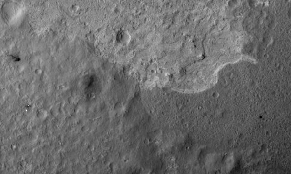
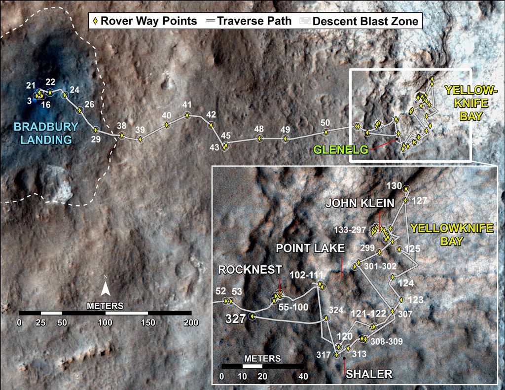
NASA engineers and geologists have finally played enough with their beloved brainchild. They shot a laser, drilled wells, found clay. 11 months after landing, they remembered that they had a research plan, and it was time to start to implement it already. For this, Curiosity must get to Sharpe Mountain (Eolida). But not anywhere - in a straight line to it is now about 3 km, and in a certain place, which was previously scheduled from the satellite - in the canyon, which is washed in the mountainside.

But, before taking a step towards the dream, Curiosity completed all the work in Glenelg and about this today's story.
Let me remind you that the rover, while landing, flew a little further away from the center of the intended landing ellipse, and deviated from the route that the creators had planned for it before sending to Mars. Despite this, the accuracy of his "primarseniya" surpasses all previous experience of NASA.
')
When scientists looked at the place where he landed Curiosity, then drew attention to one area of the landscape. About 400 meters northeast, three types of surface observed in the Gale crater met at one point. One of them is the removal of soil, which brought a stream of water from the edge of the crater. The rover just sat on it.
The second type of surface, when viewed from orbit, through the Mars Odyssey infrared camera was distinguished by high thermal inertia, i.e. it heated up for a long time and cooled down for a long time, which was very different from the neighboring areas. Outwardly, he looked like the bottom of a dry puddle - smooth and cracked.
The third type of surface attracted the attention of the high frequency of small craters. This indicated that this is the oldest site that survived millions of years of meteorite bombardment.
Scientists have decided to go to Glenelg unplanned. From the first steps of its path, Curiosity studied the surface under the "legs" and almost immediately discovered pebbles covered with water. After he got to Glenelg, scientists were faced with such a geological diversity, which was not even dreamed of. Satellite studies did not even suggest such an abundance of layers and types of rock. Curiosity conducted research after research that surprised geologists, and the apotheosis of all searches was practically moist clay extracted from the second well of Cumberland.
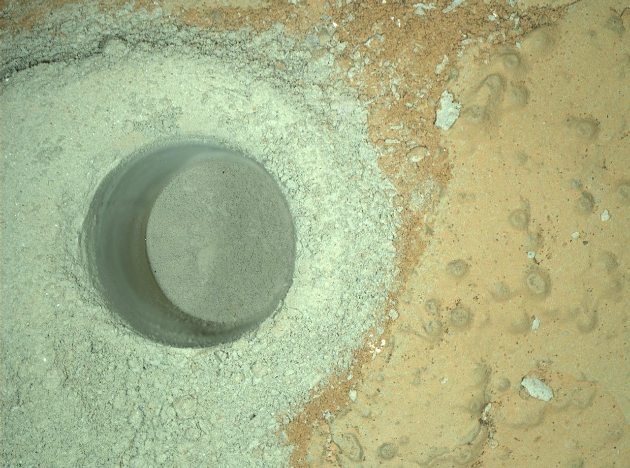
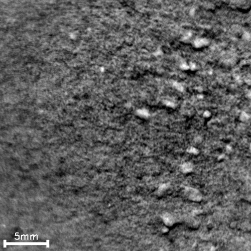
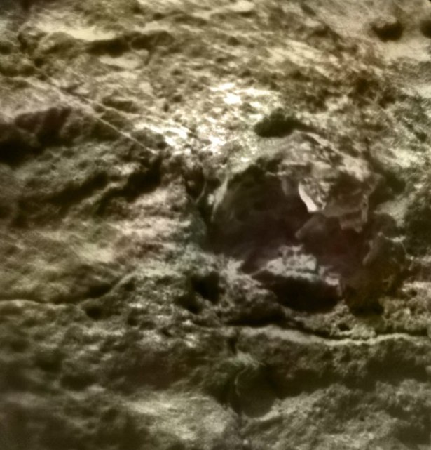
Curiosity began drilling operations at the bottom of a lowland called Yellowknifle Bay, one that looked like a dried puddle. It is not surprising that it was she who turned out to be the bottom of the lake. The water content in the clay was so high that the rover lingered for several days in the hope of detecting frost in the morning, in which water evaporating over the hole would condense. Found or not - not yet known. There are no official reports yet.
Frost trying to determine the spectrometer ChemCam
Meanwhile, the meetings of the geologists of the scientific mission were getting hotter. Scientists have argued over the future activities of the rover. Some, blinded by the abundance of Glenelg, offered to stay and continue working for several more months. Others called for a return to the early route. The latter included John Grotzinger, the programme’s supervisor. As a result, the second well became final at this stage.

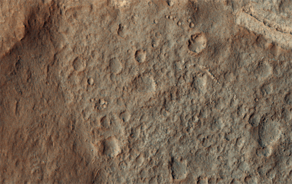
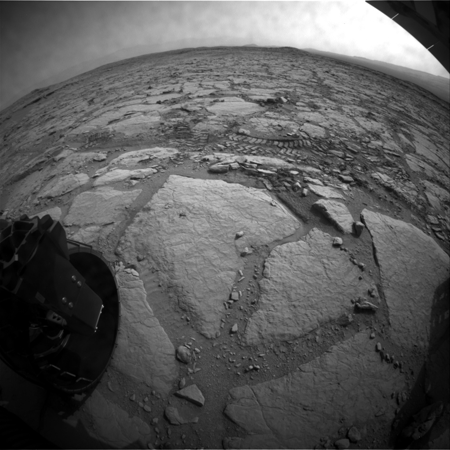
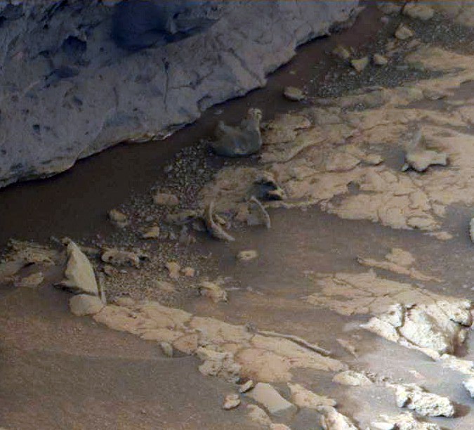
But before going on a long journey, scientists persuaded the chief to stay for another couple of months and consider the two objects, which have long been watched, but did not have enough time to get to them. The first in line was the site Point Lake. It is a dark cliff that looms over Yellowknifle Bay. They looked after him in the fall, selecting a preliminary target for testing a drill, but then they found a more interesting object and drove past.

This time the rover acted without delay. I chose a convenient place for ascent, overcame the “threshold” that separated the conventional “reservoir” from the “coast” and moved to Point Lake.
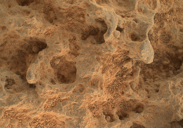
Along the way, curious "bubbles" that had been encountered in that place earlier attracted his attention. Geologically, these formations belong to the same layer as Point Lake, so the reason for their occurrence is the same.
But which is not yet known. NASA adheres to two main hypotheses: sedimentary rock or volcanic. It is emphasized that none of them are given preference. Although I think that these are still signs of a volcano. I already wrote that I looked after a suitable mountain nearby, which would suit the role of a volcano candidate, so if NASA confirms this hypothesis I would be pleased.
Point Lake wanted to explore with the MAHLI macrocamera. But the initial unit, which they were looking at, didn’t look at it - there was too uneven surface at its foot, engineers were afraid that the situation would be too unstable, and when deploying the manipulator, the rover could sway uncontrollably. Therefore, we paid attention to the close and more accessible stone.
Watch and download in ( large size VK )
On the way, he was examined through a ChemCam telescope:
And, having approached closely, the same sites removed and MAHLI.

Preliminary examination showed that the bubbly surface of the stone is heterogeneous. Inside the bubbles, there is a rock of a different composition, and it is better resists erosion. Moreover, there are interesting stones in the distance, which are still waiting for their discoverer of the shell of dinosaur eggs, from the permanent audience of REN-TV.
( color corrected )
Such a rounded shell turned out when the “bubble” collapsed due to erosion, and the breed filling it was left lying on the sand.
After MAHLI and ChemCam, Curiosity only kissed the APXS spectrometer and moved on.
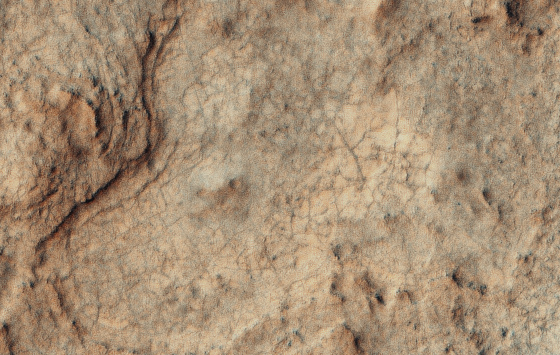
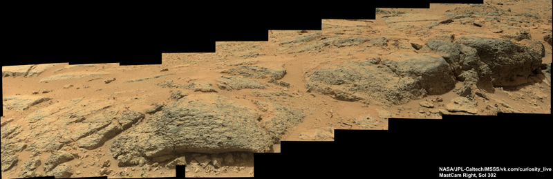
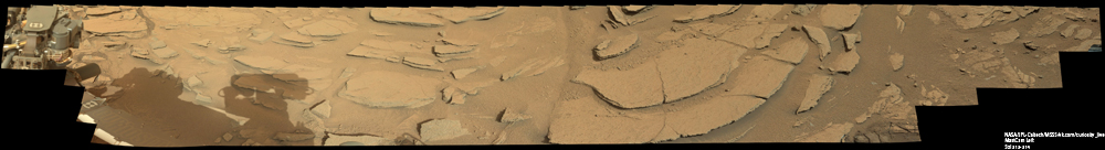
The next target was another interesting slope, which was named after the American paleontologist Shaler and examined at the beginning of the winter. Then the bottom of Yellowknifle Bay beckoned more, so the rover just took off one panorama and went down. Now it's time to come back and take a better look.
Full size on GigaPan
Shaler is a rather long area, where a rock resembling our earthy limestone emerges from the slope. But here it is most often limestone, i.e. formed with the participation of living organisms. Hope for this on Mars is no longer necessary, so NASA geologists are also considering two types of education: under the influence of wind or water. Another preliminary inspection showed that this is sandstone - i.e. ordinary sand, in which the grains of sand are joined by a cementing rock.
Geologists had to find the answer to the question of what caused the movement of this sand into such layers. Immediately preference was given to the water hypothesis, since the grains of sand were too large to be collected by the wind. The layers could vary depending on the change in the water regime, and that, in turn, on climate change. A separate intriguing moment is that the Shaler is the edge of the most ancient part of Glenelg, affected by meteorites.
Inspection of ChemCam and MAHLI allowed to see all the details.
Contrary to the original impression, the Shaler layers are anything but homogeneous. There are layers of coarse sand:
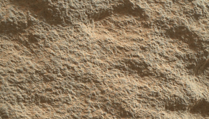
There are other highly prone to erosion:
There are, on the contrary, unusually smooth, although also eaten by time:

Of course, NASA, using data from spectrometers, and attracting experienced geologists, will receive much more information about this site than our surface view. We will wait for the next scientific conference to take a look at the publications on this topic.
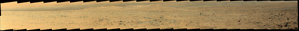
In parting, Curiosity took one last look at the foot of Mount Sharpe.
Full size on GigaPan
Everything that is to the left of the center we will never see in more detail than now.
Finally, Curiosity returned to the tracks that it laid back in October 2012, but then deviated from them and set off on its annual eight-kilometer flight.
We can only continue to follow this most exciting trophy-raid in the solar system.
But, before taking a step towards the dream, Curiosity completed all the work in Glenelg and about this today's story.
Let me remind you that the rover, while landing, flew a little further away from the center of the intended landing ellipse, and deviated from the route that the creators had planned for it before sending to Mars. Despite this, the accuracy of his "primarseniya" surpasses all previous experience of NASA.
')
When scientists looked at the place where he landed Curiosity, then drew attention to one area of the landscape. About 400 meters northeast, three types of surface observed in the Gale crater met at one point. One of them is the removal of soil, which brought a stream of water from the edge of the crater. The rover just sat on it.
The second type of surface, when viewed from orbit, through the Mars Odyssey infrared camera was distinguished by high thermal inertia, i.e. it heated up for a long time and cooled down for a long time, which was very different from the neighboring areas. Outwardly, he looked like the bottom of a dry puddle - smooth and cracked.
The third type of surface attracted the attention of the high frequency of small craters. This indicated that this is the oldest site that survived millions of years of meteorite bombardment.
Scientists have decided to go to Glenelg unplanned. From the first steps of its path, Curiosity studied the surface under the "legs" and almost immediately discovered pebbles covered with water. After he got to Glenelg, scientists were faced with such a geological diversity, which was not even dreamed of. Satellite studies did not even suggest such an abundance of layers and types of rock. Curiosity conducted research after research that surprised geologists, and the apotheosis of all searches was practically moist clay extracted from the second well of Cumberland.
Curiosity began drilling operations at the bottom of a lowland called Yellowknifle Bay, one that looked like a dried puddle. It is not surprising that it was she who turned out to be the bottom of the lake. The water content in the clay was so high that the rover lingered for several days in the hope of detecting frost in the morning, in which water evaporating over the hole would condense. Found or not - not yet known. There are no official reports yet.
Frost trying to determine the spectrometer ChemCam
Meanwhile, the meetings of the geologists of the scientific mission were getting hotter. Scientists have argued over the future activities of the rover. Some, blinded by the abundance of Glenelg, offered to stay and continue working for several more months. Others called for a return to the early route. The latter included John Grotzinger, the programme’s supervisor. As a result, the second well became final at this stage.
But before going on a long journey, scientists persuaded the chief to stay for another couple of months and consider the two objects, which have long been watched, but did not have enough time to get to them. The first in line was the site Point Lake. It is a dark cliff that looms over Yellowknifle Bay. They looked after him in the fall, selecting a preliminary target for testing a drill, but then they found a more interesting object and drove past.
This time the rover acted without delay. I chose a convenient place for ascent, overcame the “threshold” that separated the conventional “reservoir” from the “coast” and moved to Point Lake.
Along the way, curious "bubbles" that had been encountered in that place earlier attracted his attention. Geologically, these formations belong to the same layer as Point Lake, so the reason for their occurrence is the same.
But which is not yet known. NASA adheres to two main hypotheses: sedimentary rock or volcanic. It is emphasized that none of them are given preference. Although I think that these are still signs of a volcano. I already wrote that I looked after a suitable mountain nearby, which would suit the role of a volcano candidate, so if NASA confirms this hypothesis I would be pleased.
Point Lake wanted to explore with the MAHLI macrocamera. But the initial unit, which they were looking at, didn’t look at it - there was too uneven surface at its foot, engineers were afraid that the situation would be too unstable, and when deploying the manipulator, the rover could sway uncontrollably. Therefore, we paid attention to the close and more accessible stone.
Watch and download in ( large size VK )
On the way, he was examined through a ChemCam telescope:
And, having approached closely, the same sites removed and MAHLI.
Preliminary examination showed that the bubbly surface of the stone is heterogeneous. Inside the bubbles, there is a rock of a different composition, and it is better resists erosion. Moreover, there are interesting stones in the distance, which are still waiting for their discoverer of the shell of dinosaur eggs, from the permanent audience of REN-TV.
( color corrected )
Such a rounded shell turned out when the “bubble” collapsed due to erosion, and the breed filling it was left lying on the sand.
After MAHLI and ChemCam, Curiosity only kissed the APXS spectrometer and moved on.
The next target was another interesting slope, which was named after the American paleontologist Shaler and examined at the beginning of the winter. Then the bottom of Yellowknifle Bay beckoned more, so the rover just took off one panorama and went down. Now it's time to come back and take a better look.
Full size on GigaPan
Shaler is a rather long area, where a rock resembling our earthy limestone emerges from the slope. But here it is most often limestone, i.e. formed with the participation of living organisms. Hope for this on Mars is no longer necessary, so NASA geologists are also considering two types of education: under the influence of wind or water. Another preliminary inspection showed that this is sandstone - i.e. ordinary sand, in which the grains of sand are joined by a cementing rock.
Geologists had to find the answer to the question of what caused the movement of this sand into such layers. Immediately preference was given to the water hypothesis, since the grains of sand were too large to be collected by the wind. The layers could vary depending on the change in the water regime, and that, in turn, on climate change. A separate intriguing moment is that the Shaler is the edge of the most ancient part of Glenelg, affected by meteorites.
Inspection of ChemCam and MAHLI allowed to see all the details.
Contrary to the original impression, the Shaler layers are anything but homogeneous. There are layers of coarse sand:
There are other highly prone to erosion:
There are, on the contrary, unusually smooth, although also eaten by time:
Of course, NASA, using data from spectrometers, and attracting experienced geologists, will receive much more information about this site than our surface view. We will wait for the next scientific conference to take a look at the publications on this topic.
In parting, Curiosity took one last look at the foot of Mount Sharpe.
Full size on GigaPan
Everything that is to the left of the center we will never see in more detail than now.
Finally, Curiosity returned to the tracks that it laid back in October 2012, but then deviated from them and set off on its annual eight-kilometer flight.
We can only continue to follow this most exciting trophy-raid in the solar system.
Source: https://habr.com/ru/post/185846/
All Articles