The newest Russian photosource Resurs-P is successfully launched into orbit
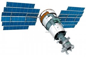 Not wanting to participate in debates about the prospects for the development of the Russian space industry (the latter were here ), I simply decided, as far as I could, to convey to the general (and progressive) audience the latest achievements in this field. Well, for example, did any of you know that just yesterday, the Russian Earth remote sensing satellite Resurs-P was successfully launched into orbit?
Resurs-P is a follower of a domestic satellite designed for remote sensing of the Earth in recent years, Resurs-DK1, developed by FSUE SRNCP TsSKB-Progress.
')
The main tasks of the apparatus Roscosmos outlined the following:
- drawing up and updating of general geographic, thematic and topographic maps;
- control of environmental pollution, including environmental control in areas of geological exploration and mining, control of water protection and conservation areas;
- inventory of natural resources (agricultural and forest land, pastures, areas of seafood trade), the creation of a land cadastre and control of economic processes to ensure rational activities in various sectors of the economy;
- information support for the search for oil, natural gas, ore and other mineral deposits;
- monitoring the development of territories, obtaining data for engineering assessment of the area in the interests of economic activity;
- information support for the construction of highways and large structures, roads, railways, oil and gas pipelines, communication systems;
- detection of illegal crops of narcotic plants and control of their destruction;
- ice assessment;
- observation of emergency areas to monitor natural disasters, accidents, catastrophes, as well as assess their consequences and plan remedial measures.
In short, the spacecraft is capable of making monochrome photographs of the earth's surface with a maximum surface resolution of up to 70 centimeters and color with a resolution of 3-4 meters.
In addition to the high-resolution optical-electronic equipment, the Resurs-P target equipment introduced two more types of imaging equipment: hyperspectral imaging equipment (GSA) and a wide-area imaging equipment complex (KHSA).

The GSA should provide imaging of the Earth’s surface in the visible and near-infrared spectral ranges from 0.4 to 1.1 μm and is based on a high-aperture mirror lens, a dispersing system and high-speed personnel photodetectors of the CCD of the visible and near infrared range. The capture band of the GAW is 25 km, and the resolution (pixel projection) is about 25 m. By the way, the CCD is of domestic production (Kadr-RP, developed at ZAO ELPP specifically for this project).
The complex of wide-spectrum multispectral imaging equipment, in essence, consists of two monoblock devices: high-resolution equipment and medium-resolution equipment, which can be operated both together and autonomously. The length of the CCD line of each device is about 8000 pixels. Telecentric lenses of two types with different focal lengths were also specially developed for the complexes. Each camera provides shooting in panchromatic (0.43-0.70) and five narrow (multispectral) ranges: 0.43-0.51 (blue); 0.51-0.58 (green); 0.60-0.70 (red); 0.70-0.90 (near IC1) and 0.80-0.90 (near IC2).
The high-resolution camera has a capture band of 96 km at a resolution of about 12 m in the panchromatic range and 24 m in multispectral channels. The medium resolution camera has a capture range of 480 km with a resolution (pixel projection) of about 60 m in the panchromatic range and 120 m in multispectral channels.
The system of receiving and converting images consists of three opto-electronic converters (panchromatic and two multispectral), a control unit and secondary power sources for OEP units. The functions of opto-electronic converters include the conversion of an optical image into an electrical signal, its amplification, analog-to-digital conversion (10 bits), compression, and packaging for transfer to the on-board storage device via a high-speed interface. It is possible to use two compression algorithms for adaptive DPCM and JPEG2000. Two multispectral EIAs can provide simultaneous imaging in six different narrow spectral ranges. The speed of the electronics is designed for operation of the Resurs-P device without pitch deceleration.
Of the currently existing foreign commercial observation systems of high resolution, the Resurs-P optoelectronic equipment is second only to the latest US dual-use satellite WorldView-2, which has 8 multispectral channels in terms of the number of multispectral channels.
According to the materials of TsSKB Progress, Geomatics magazine.
UPD Here in more detail and with pictures (thanks to the zone19 habrauser )
Source: https://habr.com/ru/post/184706/
All Articles