Mapping or welcome to vector Crimea
The events described date back to 2005.
From time immemorial my grandmother had a map of the Crimea of the 60s, which looks like a work of art. Indeed, the artist did his best, the map contains hundreds of small details, and literally every inch of it is imbued with the spirit of those past times. The eyed GAZs 51, Volga, victories, LAZs Intourist, aeroflot propellers, women at sea in bathing caps, are all now in wonder, although I still managed to live a little in that world.
')
In 2002, I had my first personal computer after the “Search” in the 90s with an Athlon 1GHz processor. After quite a bit of time, I already sparled in Photoshop, and in 2004 I had a program — a miracle of human thought — Macromedia Flash MX. In the same year, I learned the mystery of hypertext markup (HTML) and began to create my own websites. Since then, Flash is my favorite program, I do a lot on it: design elements for websites or sites themselves, layouts for printing, videos, various designers and, of course, animated banners.
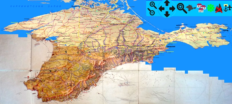
And at one point, I wanted to breathe a new, modern life into that very masterpiece card. For this there was everything you need: a scanner, a lot of detailed maps of the Crimea, various travel books with descriptions of attractions, and of course the Internet itself. The map, by the way, was quite battered by time and, apparently, by its own barbarism. There were children's scribbles on it marked with a ballpoint pen and in some places gaps in the places of bending. Without any problems, the card was scanned with a resolution of 300dpi and thus turned into a digital blank of six parts. Then all the pieces were simply reduced and loaded into a flash, where they were converted into a vector with rather coarse parameters to make smaller “polygons”. After this, the most routine work began, reducing the existing number of polygons by pouring the same pieces with the same color in the same color. I had to process several tens of thousands of pieces! It took a lot of time, as the eyes got pretty tired. Each of the remaining polygons, of which there were also thousands, was manually optimized so that it did not look complicated and crooked, and was a polygon of straight lines. All 6 parts of the map were processed in this way, and it turned out that in some way one piece is very different in color from the rest. Overlooked when scanning, but a lot of work has already been done and there was no point in redoing it. Fortunately, the program allows you to solve the problem quite simply - convert the entire piece into a symbol and adjust its color gamut with RGB sliders.
So, the most difficult and tedious behind, before the eyes of a beautiful Crimean landscape in all its beauty. Then there are more interesting tasks - filling the card with content. First of all, I took up the most missing and logical bottom layer with the Black Sea at that moment. And for this, the correct contours of the coastline of the peninsula were needed. Here comes the Google Earth program. Difficult areas with cities were otprintskrineny and the resulting images were drawn clear boundaries, after which they were combined with the map by distortion and transformation. Then the theme of water continued, and lakes and rivers appeared on the landscape. Everything was simpler with the rivers, but a lot of small lakes that were missing on the old map were borrowed from the atlas and placed on their supposed places relative to roads and settlements.
Further, a detailed atlas of the Crimea was used throughout. All roads were drawn, down to the more or less well-groomed forest ruts. All train tracks with all stations and platforms. The most important is the settlements, with them it was immediately decided to make two switching options: with all the villages or only with large ones. Each village went through my hands, put a circle and a name for it. In some places, such a density of villages that their names miraculously fit without overlap each other. If you knew how many of these Alexandrovok exist, if there are about 10 in the Crimea with different variations, then presumably in Ukraine alone there are more than a hundred. The last were the layers with the names of mountains, passes, capes and bays, and another with the designation of the Crimean sights, which are abundant on the peninsula. A description was found about each interesting place, mainly in small books that my mother bought at one time.
Well, it remains to fill all this with functionality and things to the end. Map management was added (it was taken from some German flash card of a small town), a table of distances, and a print version. When I saw the final size of the finished SWF file, I could hardly believe that this was possible. Optimization of each piece of the landscape has benefited and, as a result, a fairly large amount of graphic and textual information fit in less than 600 kilobytes!
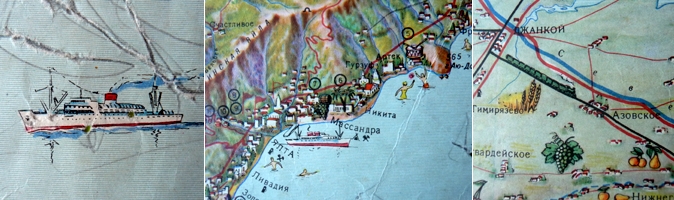
upd. I apologize for not specifying in the article that the finished product lacks all these small graphic elements in the form of ships, cars, and other things. But you must understand that this is also a very difficult and painstaking work, and it should look like it is today, without locomotives. The task was to make the file as minimal as possible by weight, but so that it contained a lot of information and it all looked different from all ordinary atlases.
You can see and download here http://crimeamap.pdatelie.net
300 dpi scan card
Map
Cover
Source: https://habr.com/ru/post/173875/
All Articles