Search for public transport is now in all versions of 2GIS
Today was the release of the search for public transport at 2GIS Online . Now you can plan your trip with any version of our directory ( PC , versions for smartphones and an online version that runs on API 2GIS ). Moreover, our largest route database is now available from virtually any device with a browser.

The search for travel on public transport works in all cities of presence of 2GIS, and these are more than 200 cities of Russia, Ukraine and Kazakhstan. In addition to the usual buses, trolley buses, trams and everything else that goes on the ground and under it, we took into account the exotic types of transport: funiculars, river trams and cable cars.
')
However, as they say, it is better to see once: go to the updated 2GIS Online and try it!
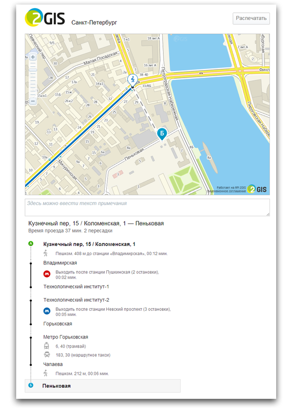
Special attention was paid to printing. Printing out the route, you will receive step by step instructions describing all types of transport and listing all transfers. Moreover, the map is displayed without small unnecessary details - only the last section of the path, which will have to go from the last stop to the building of interest to you.
As a dessert - infographics! We decided to find out in which cities it is most convenient to use public transport, where there are unusual types of it, and how far you can go on it. All this can be seen below:

UPDATE: yes, sometimes compiled routes are not entirely optimal and may seem strange. But we are constantly working to improve their compilation. Thank you all for the feedback (by the way, you can leave it through the 2GIS Online form)!
The search for travel on public transport works in all cities of presence of 2GIS, and these are more than 200 cities of Russia, Ukraine and Kazakhstan. In addition to the usual buses, trolley buses, trams and everything else that goes on the ground and under it, we took into account the exotic types of transport: funiculars, river trams and cable cars.
')
However, as they say, it is better to see once: go to the updated 2GIS Online and try it!
Special attention was paid to printing. Printing out the route, you will receive step by step instructions describing all types of transport and listing all transfers. Moreover, the map is displayed without small unnecessary details - only the last section of the path, which will have to go from the last stop to the building of interest to you.
As a dessert - infographics! We decided to find out in which cities it is most convenient to use public transport, where there are unusual types of it, and how far you can go on it. All this can be seen below:
UPDATE: yes, sometimes compiled routes are not entirely optimal and may seem strange. But we are constantly working to improve their compilation. Thank you all for the feedback (by the way, you can leave it through the 2GIS Online form)!
Source: https://habr.com/ru/post/173723/
All Articles