Technology Augmented Reality. Implementation issues for GPS navigation
Good evening, dear habrovchane! Not so long ago, I read a rather voluminous work on the topic “Augmented Reality Technology. Implementation Issues for GPS Navigation ”and would like to present the main points to the community. The main goal is to get valid criticism towards the author. So, with your permission and the permission of the author - Larushina Yulia Dmitrievny, I begin.
For people who are ignorant with the subject of conversation: Augmented Reality (augmented reality, AR) is a term that refers to all projects aimed at complementing reality with any virtual elements. Augmented reality is a component part of mixed reality (English mixed reality), which also includes “augmented virtuality” (when real objects are integrated into a virtual environment). The most common examples of augmented reality are a parallel front color line showing the location of the nearest field player to the goal during television broadcasting of football matches, arrows indicating the distance from the penalty kick to the goal, the drawn trajectory of the puck during ice hockey, etc.
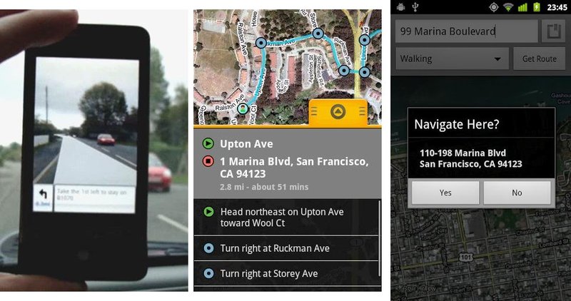
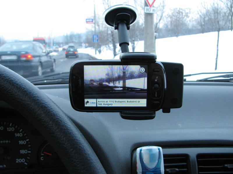
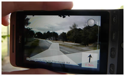
Taking a quick look at the market for applications using technology, I came to the conclusion that these applications are either entertaining in nature or are some Reality Browser - programs (Layar, Wikitude and others), or are too narrowly specialized for use in everyday life (for example Boeing's wiring application). However, I was interested in a rather interesting concept, which I repeatedly implemented in foreign markets, but I did not find the full implementation of these ideas for the CIS or former USSR countries. As many might have guessed, this is about using technology for GPS. What exactly do I mean? Screenshots of foreign implementations will say a lot better for me:
')

In my opinion, such applications can have a beneficial effect on the traffic situation, as drivers, when using an ordinary navigator, quite often have to look at the display, thereby distracting from the traffic situation. In matters of road safety, as you know, every fraction of a second is important.
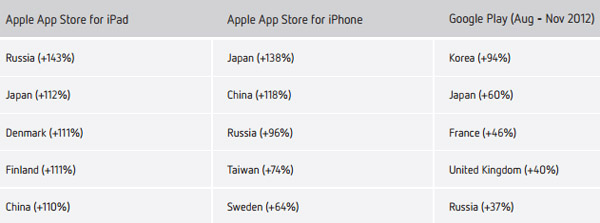
Having researched the mobile OS market, I came to the conclusion that the implementation process in a limited budget should start with the Android platform, in favor of this choice says quite a lot of facts that are not hard to find on the network, but if you’re too lazy to search, ask, I will give links to sources and conclusions for each of them. Here I will give only an entertaining result of the research of the company DISTIMO:
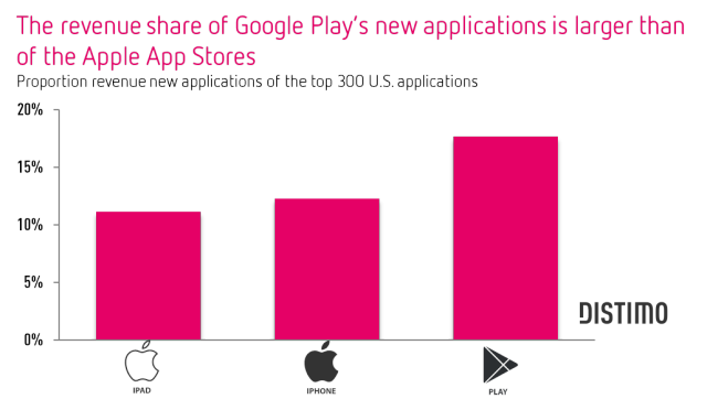
These statistics speak only of new applications, however, according to some experts, the situation of the Google Play market will soon become more favorable than on the AppStore:
The main conclusions from the analysis of the market:
A rather interesting stage of the work was the definition of the target audience, as well as the search for such features of its behavior that may affect the implementation strategy.
It is advisable to assume that the minimum age of the target audience is 18 years, that is, people who can drive motor vehicles. According to the research group TNS Global as of 2011, men accounted for approximately 60% of all drivers. Interestingly, these are mostly men from 25 to 40 years old with higher education. However, over the period from 2006 to 2011, the number of female drivers almost doubled from 1,700,000 in 2006 to 3,000 70 in 2011. The increase in the number of women drivers is still happening, thus, analysts predict that in the near future the percentage ratio will be almost equal. However, the average age and social status remain unchanged for both men and women. The company BlueStacks conducted an online survey, on the basis of which a portrait of a typical user of the Android operating system was subsequently compiled. As a result of the study, it turned out that most of the users of android-devices are men. Contrary to popular belief that gadgets are most in demand by teenagers and those who are not much over 20, the average age of a smartphone user is quite high - 30 years, and a tablet and above that - 34 years. Based on the characteristics of consumer classes, it can be concluded that it is necessary to focus on the so-called working and middle classes.
Working class:
Middle class:
Marketing agency “? QUANS! Research ”was conducted a detailed study of middle class consumers, as a result of which it was revealed that more than 40% of respondents had a car produced in 2007–2011, more than 50% of respondents had a mobile phone, or a smartphone worth more than 10,000 rubles.
Based on this data, we can determine the target audience of the future application. These are middle-class and working-class people with average incomes and above-average incomes, having an atmobile and a smartphone aged 22 to 40 years old with higher education, usually married, either working for hire, or owning small companies. As a rule, such people are subject to the influence of trends. If we talk about the attitude to the market of mobile applications, such people are willing to pay, as a rule, the non-priced price for popular applications that can make life easier, or entertainment applications. Often, the choice is based on the number of downloads of the application, its rating and user comments more than on real benefits and descriptions.
In this section, an approximate calculation of the costs of creating an application, based on average market prices and wage levels, was carried out. I think this part does not represent much value, so I will write only a conclusion.
In total, the development of the initial version of this software will take 65 working days, or approximately 90 calendar days. Thus, the development of this application will require at least 1 474 000 rubles.
Here I urge you to be attentive and provide as much substantiated criticism as possible , I will quote most of the section, since I doubt it most of all and some of the data seem to me unreliable. Moreover, the presence of logical errors and incorrect conclusions is possible.
When it comes to GPS navigation, do not forget about the problems associated with the use of such systems. Often, the maps currently available in many places may be inaccurate, and information about them is outdated. In this case, in order to avoid an error in laying a route, it is necessary to exclude the consideration of secondary roads. Your route may be longer, but you will definitely get to the right destination.
Undoubtedly, it is worth noting the problem with the accuracy of GPS navigation: the “Classic” GPS sensor gives a minimum error of 3 to 30 m. Accordingly, using only the data provided by GPS satellites is simply meaningless and you need to find a solution to the accuracy of such an application.
Since the main task of augmented reality is the synthesis of real and virtual objects in space, the need arises to pre-digitize data on the surrounding space. Registration of the geometric spatial characteristics of small rooms today has become the norm for a wide range of specialists. Everything turns out to be much more complicated when it comes to open spaces: how are virtual and real objects mutually located, which of them is in the foreground?
In fact, such a technically complex idea as combining the technology of complementing reality and GPS navigation has a lot of problems, because the technology of augmented reality has only recently begun to actively develop, and GPS technology despite the fact that it has been used for a long time so far Solved problems with accuracy readings.
It is worth noting that these problems are characteristic of almost all modern applications based on the addition of reality, which in turn means that at least a partial solution of these problems can be turned into quite serious competitive advantages.
Modern smartphones are usually equipped with built-in GPS-module, so necessary for the operation of our application. To solve the problem with the accuracy of readings and, as a consequence, a more accurate display of the necessary information, it was proposed to use several means at once: GPS module, built-in digital compass and built-in gyroscope. The combination of a gyroscope and a compass gives quite good results, and if you add to them the recognition of images of previously known landscape elements, the accuracy increases to the pixel level. The discrepancy is measured in pixels solely due to the peculiarities of the human brain and vision, which can reveal the slightest mistake when placing virtual objects in real space. # Thus, we can highlight the main, in the author’s opinion, competitive advantage - accuracy of navigation and data display. This advantage is able to distinguish the application not only from a number of similar (ie, applications based on the addition of reality), but also from a number of conventional GPS navigators, because it has more methods for determining the location based on different technologies.
Another common problem of technology-based applications lies in the fact that, as a rule, they try to cover a wide range of tasks, which immediately leads to two negative consequences: low speed of work on mobile devices and high complexity of application development. The author of the work studied in detail the most popular applications, such as: Layar, AugSatNav, Wikitude, AlterGeo and tested them on a device that has average technical characteristics by today's standards (see Appendix 1). Interestingly, any serious problems with speed, stability, or user interface arose when using each application. According to the author, if you clearly restrict the list of tasks solved by applications to ensure accurate navigation, you can significantly improve the quality of the application as a whole and its speed.
When using standard GPS-navigators in modern road conditions, the issue of traffic safety while using the device is quite acute. Indeed, quite often the driver is forced to look at the display device, thereby distracting from the traffic situation. Suppose that the driver is distracted for a split second, but, as you know, every thousandth of a second can sometimes cost health or even life. The proposed application is primarily intended to solve this problem, because with its implementation, the driver, even looking at the route, will be able to follow the traffic situation, since everything that happens on the road is displayed on the device screen with the application running in real time.
Plan for introducing software based on Augmented Reality technology for GPS navigation in the Google Play application market
Purpose of the idea: this project is designed to provide GPS navigation on the basis of modern mobile platforms, as well as increase the level of safety on the roads.
Market: Potential consumers of the software are men and women from 22 to 40 years old who have at least 1 car in the family, with average incomes, who own a modern Android OS-based mobile device, equipped with a GPS module and an integrated camera. Implementation is planned through the official app store Google Play.
Technologies: Augmented Reality, GPS, G-Sensor, computer vision.
Inventions: no.
Products - analogues in Russia: no.
Analogous products in the world: Wikitude Drive, AugSatNav, Layar
Advantages: high accuracy of navigation, focus on one task, support for maps of Russia.
Basic needs: For the further development of the project it is necessary: to create a working group consisting of: 5 programmers, 2 interface designers, 1 software engineer, 1 manager, 1 system administrator, 1 database administrator. Investment requirement is: 1 474 000.
Stages of software implementation:
In general, I hope that at least someone is interested in this topic, if so, I will continue and lay out a more detailed consideration of the key points. It is worth noting that I took the analysis and description of the implementation stages quite seriously.
For people who are ignorant with the subject of conversation: Augmented Reality (augmented reality, AR) is a term that refers to all projects aimed at complementing reality with any virtual elements. Augmented reality is a component part of mixed reality (English mixed reality), which also includes “augmented virtuality” (when real objects are integrated into a virtual environment). The most common examples of augmented reality are a parallel front color line showing the location of the nearest field player to the goal during television broadcasting of football matches, arrows indicating the distance from the penalty kick to the goal, the drawn trajectory of the puck during ice hockey, etc.
Taking a quick look at the market for applications using technology, I came to the conclusion that these applications are either entertaining in nature or are some Reality Browser - programs (Layar, Wikitude and others), or are too narrowly specialized for use in everyday life (for example Boeing's wiring application). However, I was interested in a rather interesting concept, which I repeatedly implemented in foreign markets, but I did not find the full implementation of these ideas for the CIS or former USSR countries. As many might have guessed, this is about using technology for GPS. What exactly do I mean? Screenshots of foreign implementations will say a lot better for me:
')
In my opinion, such applications can have a beneficial effect on the traffic situation, as drivers, when using an ordinary navigator, quite often have to look at the display, thereby distracting from the traffic situation. In matters of road safety, as you know, every fraction of a second is important.
Having researched the mobile OS market, I came to the conclusion that the implementation process in a limited budget should start with the Android platform, in favor of this choice says quite a lot of facts that are not hard to find on the network, but if you’re too lazy to search, ask, I will give links to sources and conclusions for each of them. Here I will give only an entertaining result of the research of the company DISTIMO:
These statistics speak only of new applications, however, according to some experts, the situation of the Google Play market will soon become more favorable than on the AppStore:
Android will earn on a par with iOS. The trend noted by some developers in 2012 will continue to gain momentum and in the current one - Android applications will start earning and will do it no worse than iOS applications. Google is investing enormous efforts in monetizing its users and increasing the base of paying users, which is already bearing fruit and how the snowball will improve this situation in 2013. It is still difficult to predict, but most likely Android will even overtake iOS in terms of money by the end of the year.- Mobile app market 2013: 10 trends.
The main conclusions from the analysis of the market:
- At the moment, applications for GPS navigation using the technology of augmented relevancy are quite in demand in the Russian segment of the market for Android applications
- The mobile applications market is actively developing, statistics on the company's revenues in this market suggests that you can build a profitable business
The target audience
A rather interesting stage of the work was the definition of the target audience, as well as the search for such features of its behavior that may affect the implementation strategy.
It is advisable to assume that the minimum age of the target audience is 18 years, that is, people who can drive motor vehicles. According to the research group TNS Global as of 2011, men accounted for approximately 60% of all drivers. Interestingly, these are mostly men from 25 to 40 years old with higher education. However, over the period from 2006 to 2011, the number of female drivers almost doubled from 1,700,000 in 2006 to 3,000 70 in 2011. The increase in the number of women drivers is still happening, thus, analysts predict that in the near future the percentage ratio will be almost equal. However, the average age and social status remain unchanged for both men and women. The company BlueStacks conducted an online survey, on the basis of which a portrait of a typical user of the Android operating system was subsequently compiled. As a result of the study, it turned out that most of the users of android-devices are men. Contrary to popular belief that gadgets are most in demand by teenagers and those who are not much over 20, the average age of a smartphone user is quite high - 30 years, and a tablet and above that - 34 years. Based on the characteristics of consumer classes, it can be concluded that it is necessary to focus on the so-called working and middle classes.
Working class:
- It follows stereotypes, incl. on the traditional division of responsibilities between men and women.
- Needs emotional and monetary support from loved ones.
- Needs promotion
- Needs Shopping Tips
- Needs help in difficult times
Middle class:
- Often buy popular products to keep up with fashion
- Make "everything as it should be"
- They believe that the money should be invested in the education of children, their getting higher education
Marketing agency “? QUANS! Research ”was conducted a detailed study of middle class consumers, as a result of which it was revealed that more than 40% of respondents had a car produced in 2007–2011, more than 50% of respondents had a mobile phone, or a smartphone worth more than 10,000 rubles.
Based on this data, we can determine the target audience of the future application. These are middle-class and working-class people with average incomes and above-average incomes, having an atmobile and a smartphone aged 22 to 40 years old with higher education, usually married, either working for hire, or owning small companies. As a rule, such people are subject to the influence of trends. If we talk about the attitude to the market of mobile applications, such people are willing to pay, as a rule, the non-priced price for popular applications that can make life easier, or entertainment applications. Often, the choice is based on the number of downloads of the application, its rating and user comments more than on real benefits and descriptions.
Calculating the estimated cost of creating an application
In this section, an approximate calculation of the costs of creating an application, based on average market prices and wage levels, was carried out. I think this part does not represent much value, so I will write only a conclusion.
In total, the development of the initial version of this software will take 65 working days, or approximately 90 calendar days. Thus, the development of this application will require at least 1 474 000 rubles.
Competitive advantages
Here I urge you to be attentive and provide as much substantiated criticism as possible , I will quote most of the section, since I doubt it most of all and some of the data seem to me unreliable. Moreover, the presence of logical errors and incorrect conclusions is possible.
When it comes to GPS navigation, do not forget about the problems associated with the use of such systems. Often, the maps currently available in many places may be inaccurate, and information about them is outdated. In this case, in order to avoid an error in laying a route, it is necessary to exclude the consideration of secondary roads. Your route may be longer, but you will definitely get to the right destination.
Undoubtedly, it is worth noting the problem with the accuracy of GPS navigation: the “Classic” GPS sensor gives a minimum error of 3 to 30 m. Accordingly, using only the data provided by GPS satellites is simply meaningless and you need to find a solution to the accuracy of such an application.
Since the main task of augmented reality is the synthesis of real and virtual objects in space, the need arises to pre-digitize data on the surrounding space. Registration of the geometric spatial characteristics of small rooms today has become the norm for a wide range of specialists. Everything turns out to be much more complicated when it comes to open spaces: how are virtual and real objects mutually located, which of them is in the foreground?
In fact, such a technically complex idea as combining the technology of complementing reality and GPS navigation has a lot of problems, because the technology of augmented reality has only recently begun to actively develop, and GPS technology despite the fact that it has been used for a long time so far Solved problems with accuracy readings.
It is worth noting that these problems are characteristic of almost all modern applications based on the addition of reality, which in turn means that at least a partial solution of these problems can be turned into quite serious competitive advantages.
Modern smartphones are usually equipped with built-in GPS-module, so necessary for the operation of our application. To solve the problem with the accuracy of readings and, as a consequence, a more accurate display of the necessary information, it was proposed to use several means at once: GPS module, built-in digital compass and built-in gyroscope. The combination of a gyroscope and a compass gives quite good results, and if you add to them the recognition of images of previously known landscape elements, the accuracy increases to the pixel level. The discrepancy is measured in pixels solely due to the peculiarities of the human brain and vision, which can reveal the slightest mistake when placing virtual objects in real space. # Thus, we can highlight the main, in the author’s opinion, competitive advantage - accuracy of navigation and data display. This advantage is able to distinguish the application not only from a number of similar (ie, applications based on the addition of reality), but also from a number of conventional GPS navigators, because it has more methods for determining the location based on different technologies.
Another common problem of technology-based applications lies in the fact that, as a rule, they try to cover a wide range of tasks, which immediately leads to two negative consequences: low speed of work on mobile devices and high complexity of application development. The author of the work studied in detail the most popular applications, such as: Layar, AugSatNav, Wikitude, AlterGeo and tested them on a device that has average technical characteristics by today's standards (see Appendix 1). Interestingly, any serious problems with speed, stability, or user interface arose when using each application. According to the author, if you clearly restrict the list of tasks solved by applications to ensure accurate navigation, you can significantly improve the quality of the application as a whole and its speed.
When using standard GPS-navigators in modern road conditions, the issue of traffic safety while using the device is quite acute. Indeed, quite often the driver is forced to look at the display device, thereby distracting from the traffic situation. Suppose that the driver is distracted for a split second, but, as you know, every thousandth of a second can sometimes cost health or even life. The proposed application is primarily intended to solve this problem, because with its implementation, the driver, even looking at the route, will be able to follow the traffic situation, since everything that happens on the road is displayed on the device screen with the application running in real time.
Plan for introducing software based on Augmented Reality technology for GPS navigation in the Google Play application market
Purpose of the idea: this project is designed to provide GPS navigation on the basis of modern mobile platforms, as well as increase the level of safety on the roads.
Market: Potential consumers of the software are men and women from 22 to 40 years old who have at least 1 car in the family, with average incomes, who own a modern Android OS-based mobile device, equipped with a GPS module and an integrated camera. Implementation is planned through the official app store Google Play.
Technologies: Augmented Reality, GPS, G-Sensor, computer vision.
Inventions: no.
Products - analogues in Russia: no.
Analogous products in the world: Wikitude Drive, AugSatNav, Layar
Advantages: high accuracy of navigation, focus on one task, support for maps of Russia.
Basic needs: For the further development of the project it is necessary: to create a working group consisting of: 5 programmers, 2 interface designers, 1 software engineer, 1 manager, 1 system administrator, 1 database administrator. Investment requirement is: 1 474 000.
Stages of software implementation:
- Development of a working prototype and its testing
- Development of a unique design of the application, logo, logos
- User interface design, according to application design
- Creation of the website of the application
- Creating pages in social networks
- Creation of advertising texts, descriptions, instructions and documentation
- Software publishing in the app store
- Application Promotion
In general, I hope that at least someone is interested in this topic, if so, I will continue and lay out a more detailed consideration of the key points. It is worth noting that I took the analysis and description of the implementation stages quite seriously.
Source: https://habr.com/ru/post/173423/
All Articles