We are driving a car with 2GIS
Many users of the mobile version of 2GIS were puzzled: why the application can be directions for public transport, but not for a personal car?
To resolve this issue is intended to update the mobile 2GIS, in which the calculation of the route of travel by car appears.
You can select route points at once in several ways: using the search by organization or address in the directory, or, for example, by marking the route points on the map. A third submission has been added to the two previously available access methods: now you can find out how to get to the place you need by ground transport, by subway, or by car. As you, probably, understood, for all three ways of journey 3 separate routes with the features are calculated. What is important in Novosibirsk (and henceforth in other cities where 2GIS Traffic jams will appear), when calculating the route for a car, statistical information about the workload of the city’s network accumulated earlier is used. Routes are built in such a way as to reduce the likelihood of getting into a traffic jam, focusing on the typical workload for the current time of day.

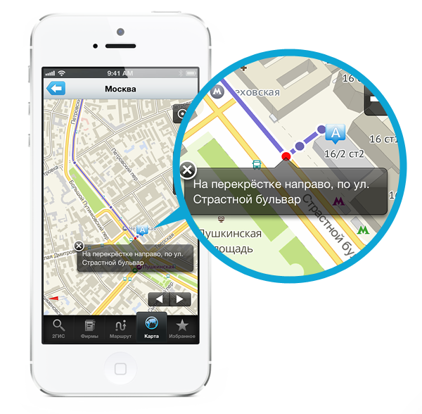
Calculation of the route for the car allows you to use mobile 2GIS as a navigation application. The program can track your location and scroll the map in accordance with your movement, which will allow you to follow the route. Places where it is necessary to change the direction of movement (for example, turn at an intersection) will be marked on the map with text prompts with appropriate recommendations.
')

You can use this feature now, the updated 2GIS is available in Google Play and the App Store .
To resolve this issue is intended to update the mobile 2GIS, in which the calculation of the route of travel by car appears.
You can select route points at once in several ways: using the search by organization or address in the directory, or, for example, by marking the route points on the map. A third submission has been added to the two previously available access methods: now you can find out how to get to the place you need by ground transport, by subway, or by car. As you, probably, understood, for all three ways of journey 3 separate routes with the features are calculated. What is important in Novosibirsk (and henceforth in other cities where 2GIS Traffic jams will appear), when calculating the route for a car, statistical information about the workload of the city’s network accumulated earlier is used. Routes are built in such a way as to reduce the likelihood of getting into a traffic jam, focusing on the typical workload for the current time of day.
Calculation of the route for the car allows you to use mobile 2GIS as a navigation application. The program can track your location and scroll the map in accordance with your movement, which will allow you to follow the route. Places where it is necessary to change the direction of movement (for example, turn at an intersection) will be marked on the map with text prompts with appropriate recommendations.
')
You can use this feature now, the updated 2GIS is available in Google Play and the App Store .
Source: https://habr.com/ru/post/165323/
All Articles