How we collect data for Nokia Maps
Maps and navigation in recent times do not disappear from the focus of attention of the IT public. Since the web has become social, navigation has proven to be one of its pillars, on which numerous services and applications rely. Today we will talk a little about how we collect data for our maps - maps.nokia.com .

Cartography, a science known to everyone from children's atlases that is more than 5 thousand years old, in conjunction with computers turns out to be the most advanced frontier of combined realities, turning our world into databases suitable for processing. The most beautiful part in creating maps is that the indexing of the physical world still requires people to travel on cars and to process the collected material at the computer.
Different cartographic companies have different approaches to creating their offspring. For example, while competitors from the search business travel 5 million miles on their cars, Nokia receives a large amount of map data from various commercial shipping companies, such as FedEx. Carriers travel about 3.3 billion miles a year. We receive about 12 billion data packages from our partners every month. In addition, the mapping uses user navigation data.
')
Also, these data allow you to track changes in existing roads and the emergence of new ones. In 2012, GPS data were used to refine 65,000 road segments. GPS data is also used to determine road congestion, as the speed at which cars move is also known.

It is worth noting that in connection with the concern for the rights of the user, every 30 seconds the tracking of information stops, so we do not fix specific routes by which a certain person moves.
In the future, we at Nokia expect to receive up to 30 different parameters from a GPS request, which will keep our maps up to date without having to send employees to drive along the roads. In the meantime, this system is, unfortunately, auxiliary.
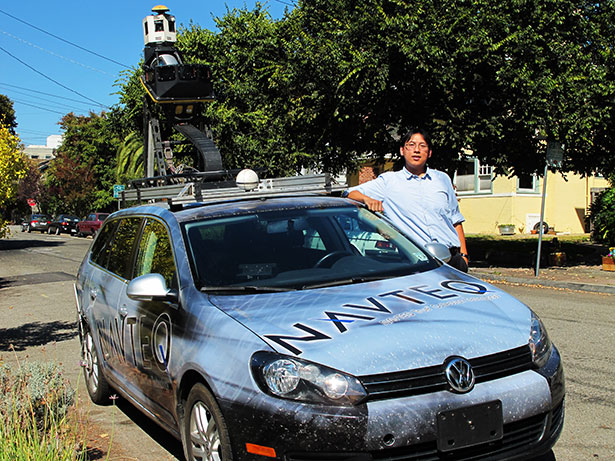
In addition to FedEx and user devices, the data collection is handled by researchers-drivers who control Nokia's “True” machines. For this kind of work, a special nature of character is needed, since it requires constantly moving around, mapping another major city. Months without close people, spending the night in one or the other hotel are normal conditions for our researchers. The specificity of the cameras installed on the machine is such that they work best in dry conditions, so this work is of a pronounced seasonal nature. In the north, drivers work in the summer, and with the onset of winter they move to the south.
Inside a particular city, the route is planned according to an algorithm that determines the most efficient way to travel and record each road on the map. The algorithm, of course, is quite flexible and can make mistakes, but the system makes a certain route and tries to follow it. Drivers drive 8-9 hours a day and then return to the hotel. The next day, they return to the point where they stopped yesterday and continue to follow a given route.
On the roof of "True" installed a large amount of equipment, one on top of another. In a fully expanded state, the height of the module is about 2 meters.
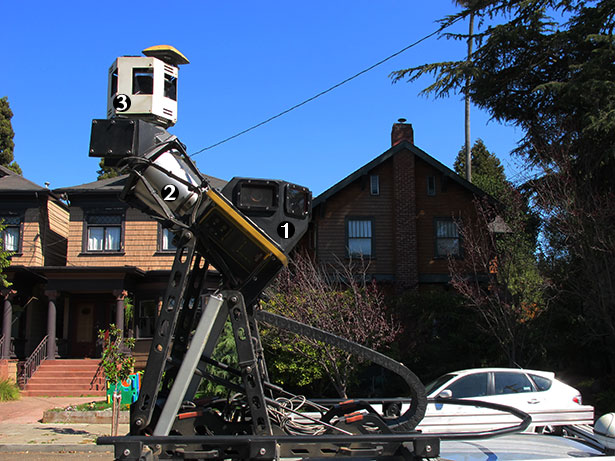
1 - Six cameras removing road signs. 2 - LIDAR. 3 - Panoramic camera.
The car is equipped with equipment worth about $ 200,000. This includes 6 cameras that shoot street signs, a panoramic camera to create the Bing Street View gallery (Microsoft uses our maps), two GPS antennas, three laptops and the main jewel is the LIDAR system, which “shoots” 64 lasers all 360 degrees around the car to create a three-dimensional model of the terrain on which the car travels.
LIDAR is used for different purposes, especially when combined with other visual data. He makes 1.3 million measurements per second, which are combined into a single picture of the street. These data are then superimposed on the picture taken by other cameras on the roof to create a digital cast of the terrain.
After we have a digital version of the environment, we can get almost any data from the images of the terrain. With their help, one can easily calculate, for example, the height and width of the bridge, as if “reading” the physical world around. And you can decipher various signs and pointers to understand the location of the transport network around. We can retrieve and recognize 100 different types of signs and pointers in 13 different countries of the world automatically.
The biggest problem of creating maps, due to which we have to actively use our own “True” cars, lies not in three dimensions, but in the fourth - the world changes with time. Creating a map is a relatively simple task compared to its further support up to date.
We collect up to 400 pieces of information on each segment of the road. This may be information about the signs, where the road leads, about the number of lanes or about repair work. This is a huge amount of information. When we talk about the percentage change, it can be a speed limit or a name on a certain highway. This is an ongoing process of understanding the dynamic nature of changes in these road networks.
We have a concept called The Living Map. The idea is that as soon as a person begins to use the map and additional location services, the map begins to find out what the person is looking for. And over time, you begin to connect the places you like, gradually turning this network into a new layer on top of all the traffic data carefully collected for you by the Nokia team.
Cartography, a science known to everyone from children's atlases that is more than 5 thousand years old, in conjunction with computers turns out to be the most advanced frontier of combined realities, turning our world into databases suitable for processing. The most beautiful part in creating maps is that the indexing of the physical world still requires people to travel on cars and to process the collected material at the computer.
Different cartographic companies have different approaches to creating their offspring. For example, while competitors from the search business travel 5 million miles on their cars, Nokia receives a large amount of map data from various commercial shipping companies, such as FedEx. Carriers travel about 3.3 billion miles a year. We receive about 12 billion data packages from our partners every month. In addition, the mapping uses user navigation data.
')
Also, these data allow you to track changes in existing roads and the emergence of new ones. In 2012, GPS data were used to refine 65,000 road segments. GPS data is also used to determine road congestion, as the speed at which cars move is also known.
It is worth noting that in connection with the concern for the rights of the user, every 30 seconds the tracking of information stops, so we do not fix specific routes by which a certain person moves.
In the future, we at Nokia expect to receive up to 30 different parameters from a GPS request, which will keep our maps up to date without having to send employees to drive along the roads. In the meantime, this system is, unfortunately, auxiliary.
In addition to FedEx and user devices, the data collection is handled by researchers-drivers who control Nokia's “True” machines. For this kind of work, a special nature of character is needed, since it requires constantly moving around, mapping another major city. Months without close people, spending the night in one or the other hotel are normal conditions for our researchers. The specificity of the cameras installed on the machine is such that they work best in dry conditions, so this work is of a pronounced seasonal nature. In the north, drivers work in the summer, and with the onset of winter they move to the south.
Inside a particular city, the route is planned according to an algorithm that determines the most efficient way to travel and record each road on the map. The algorithm, of course, is quite flexible and can make mistakes, but the system makes a certain route and tries to follow it. Drivers drive 8-9 hours a day and then return to the hotel. The next day, they return to the point where they stopped yesterday and continue to follow a given route.
On the roof of "True" installed a large amount of equipment, one on top of another. In a fully expanded state, the height of the module is about 2 meters.
1 - Six cameras removing road signs. 2 - LIDAR. 3 - Panoramic camera.
The car is equipped with equipment worth about $ 200,000. This includes 6 cameras that shoot street signs, a panoramic camera to create the Bing Street View gallery (Microsoft uses our maps), two GPS antennas, three laptops and the main jewel is the LIDAR system, which “shoots” 64 lasers all 360 degrees around the car to create a three-dimensional model of the terrain on which the car travels.
LIDAR is used for different purposes, especially when combined with other visual data. He makes 1.3 million measurements per second, which are combined into a single picture of the street. These data are then superimposed on the picture taken by other cameras on the roof to create a digital cast of the terrain.
After we have a digital version of the environment, we can get almost any data from the images of the terrain. With their help, one can easily calculate, for example, the height and width of the bridge, as if “reading” the physical world around. And you can decipher various signs and pointers to understand the location of the transport network around. We can retrieve and recognize 100 different types of signs and pointers in 13 different countries of the world automatically.
The biggest problem of creating maps, due to which we have to actively use our own “True” cars, lies not in three dimensions, but in the fourth - the world changes with time. Creating a map is a relatively simple task compared to its further support up to date.
We collect up to 400 pieces of information on each segment of the road. This may be information about the signs, where the road leads, about the number of lanes or about repair work. This is a huge amount of information. When we talk about the percentage change, it can be a speed limit or a name on a certain highway. This is an ongoing process of understanding the dynamic nature of changes in these road networks.
We have a concept called The Living Map. The idea is that as soon as a person begins to use the map and additional location services, the map begins to find out what the person is looking for. And over time, you begin to connect the places you like, gradually turning this network into a new layer on top of all the traffic data carefully collected for you by the Nokia team.
Source: https://habr.com/ru/post/155567/
All Articles