The program "taught" to determine the city by architecture
Generations of architects and designers (there was no such term as a designer before) worked for hundreds of years, creating unique outlines of different cities and individual buildings. Of course, each city showed individual features over time (meaning large cities, like Paris and New York, small industrial settlements have practically no individuality). It is clear that many of us, looking at a photograph of a pair of buildings of any city, are able to say whether it is Paris, New York or Beijing. Now software is capable of this.
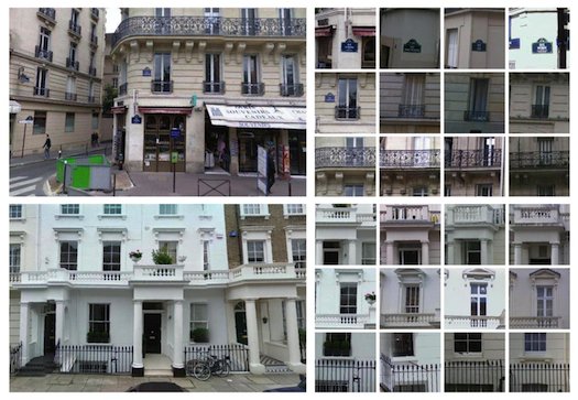
Researchers from Carnegie Mellon University and INRIA / Ecole Normale Supérieure (Paris) created a program that highlights the characteristics of buildings from hundreds of thousands of Google Street View pictures from different cities. For some cities it can be a large number of fire exits, for another - a huge number of balconies and balconies with metal fencing. There are a lot of elements isolated by the program, there are thousands of them, and all of them are a distinctive feature of any cities.
')
The principle of the system is related to the usual many data mining. However, in our case, the system receives data from the images. As a result, a single image of the urban landscape can be used to determine the city where the locality from the photo is located. In addition, the system can analyze, and report what type of lights, balconies, columns for which city are characteristic. In some cases, from a snapshot of one building, this program allows you to specify in which city this building stands.
Of course, the program is not yet able to determine the twin cities, where there are no individual features. In addition, in large cities, the system sometimes makes mistakes. Nevertheless, the project is quite interesting, and the developers are gradually improving and “teaching” their offspring.
Via popsci.com
Source: https://habr.com/ru/post/149354/
All Articles