What can be seen on satellite images? Part 1. Places forbidden to view
Many places on satellite imagery are censored. The main purpose of this is to prevent possible terrorists from carrying out their attacks, having studied in detail the terrain and infrastructure of the object, as well as to hide secret and many strategic objects.
It’s no secret that since the launch of Google’s maps, the main US government buildings (such as the White House and the Capitol) have been artificially painted over — you could spot snipers on the roofs and many other things that weren’t meant for those extra eyes.
The fact that access to information on the placement of strategic objects in aerial and satellite images can be known has long been known. In the midst of the Cold War, in 1962, images of Cuba’s territory from reconnaissance aircraft (then analogous to the current satellite images) led to the Caribbean crisis , which could easily have developed into a global nuclear war. Many years later, satellite imagery allowed America to easily monitor this territory and evaluate Cuban potential.

Strategic Soviet reconnaissance aircraft (modification of a Tu-95 bomber ) at the airfield of Cuba, 1980. Satellite image.
')
Now every influential state can afford to have its own satellite in orbit. Therefore, the goals of hiding such objects have changed a bit. The main threat now is international terrorism.
At the end of 2008, a series of large-scale terrorist attacks took place in the Indian city of Mumbai . Later, one of the captured terrorists said that Google maps were used for the preparation, on which all the secret Indian objects and sights were available. Earlier, representatives of Palestinian terrorists also admitted that they use Google satellite maps to plan rocket attacks on Israel.
In response, Assembly Member Joel Anderson proposed a law on censorship for satellite maps , according to which public schools should be covered with educational institutions, government buildings, and religious and medical institutions. All is well, but this law is limited only to California.
There is still no single law (in some countries there are no such laws at all), and this leads to the fact that places not available on Google Maps can be easily observed in other systems (Bing Maps, Yahoo maps, Yandex maps, etc. .), and vice versa.
Some places are hidden at the request of individuals and organizations: the lawsuit of Aaron and Christina Boring from Pittsburgh to Google is indicative. The couple filed a lawsuit for $ 25,000 for what, in their opinion, some pictures were taken in their territory, and this violates their right to privacy. The pair lost the case without receiving a refund, but the controversial photos were still deleted.
There are several ways to hide places on satellite images:
To get the best effect, the above methods can be combined.
Having studied many well-known hidden places on maps, many variants of ways to conceal images become noticeable: for example, up to a dozen species can be found per pixelation. And yet - the dependence of the method of hiding images from the country is very clearly monitored. It can be concluded that countries themselves are engaged in hiding "interesting" places - the way they are comfortable.
In terms of concealment, the well-known truth works: in the best way that which is visible to everyone is hidden. Hiding the same part of previously available images usually does not occur unnoticed, and these sites attract increased attention.
The American news organization Mother Jones, based on information available to the public (including data from satellite images), even compiled a detailed map of the location of nuclear facilities in the United States .
A small collection of such prohibited for viewing places some time ago was already on Habré .
Today there will be a continuation of 10 new interesting places that did not fall into the last review.
Such censorship is not always constant, there are many cases where the restriction on viewing was removed and previously hidden objects on satellite maps became fully visible for viewing.
Wikipedia has a page (in English) that lists the hidden locations on satellite maps by state.
To be continued...
It’s no secret that since the launch of Google’s maps, the main US government buildings (such as the White House and the Capitol) have been artificially painted over — you could spot snipers on the roofs and many other things that weren’t meant for those extra eyes.
The fact that access to information on the placement of strategic objects in aerial and satellite images can be known has long been known. In the midst of the Cold War, in 1962, images of Cuba’s territory from reconnaissance aircraft (then analogous to the current satellite images) led to the Caribbean crisis , which could easily have developed into a global nuclear war. Many years later, satellite imagery allowed America to easily monitor this territory and evaluate Cuban potential.
Strategic Soviet reconnaissance aircraft (modification of a Tu-95 bomber ) at the airfield of Cuba, 1980. Satellite image.
')
Now every influential state can afford to have its own satellite in orbit. Therefore, the goals of hiding such objects have changed a bit. The main threat now is international terrorism.
At the end of 2008, a series of large-scale terrorist attacks took place in the Indian city of Mumbai . Later, one of the captured terrorists said that Google maps were used for the preparation, on which all the secret Indian objects and sights were available. Earlier, representatives of Palestinian terrorists also admitted that they use Google satellite maps to plan rocket attacks on Israel.
In response, Assembly Member Joel Anderson proposed a law on censorship for satellite maps , according to which public schools should be covered with educational institutions, government buildings, and religious and medical institutions. All is well, but this law is limited only to California.
There is still no single law (in some countries there are no such laws at all), and this leads to the fact that places not available on Google Maps can be easily observed in other systems (Bing Maps, Yahoo maps, Yandex maps, etc. .), and vice versa.
Some places are hidden at the request of individuals and organizations: the lawsuit of Aaron and Christina Boring from Pittsburgh to Google is indicative. The couple filed a lawsuit for $ 25,000 for what, in their opinion, some pictures were taken in their territory, and this violates their right to privacy. The pair lost the case without receiving a refund, but the controversial photos were still deleted.
There are several ways to hide places on satellite images:
- Pixelation
- Blur image.
- Closing an image with a monochromatic patch (an outdated method, defects in gluing the image, etc., also lead to a similar effect).
- Replacing parts of maps that need to be hidden with lower-resolution images (either this area is not updated at all and remains as it is) or older (by the date of the shooting).
- Masking is the most difficult, and therefore the most reliable way to hide.
To get the best effect, the above methods can be combined.
Having studied many well-known hidden places on maps, many variants of ways to conceal images become noticeable: for example, up to a dozen species can be found per pixelation. And yet - the dependence of the method of hiding images from the country is very clearly monitored. It can be concluded that countries themselves are engaged in hiding "interesting" places - the way they are comfortable.
In terms of concealment, the well-known truth works: in the best way that which is visible to everyone is hidden. Hiding the same part of previously available images usually does not occur unnoticed, and these sites attract increased attention.
The American news organization Mother Jones, based on information available to the public (including data from satellite images), even compiled a detailed map of the location of nuclear facilities in the United States .
A small collection of such prohibited for viewing places some time ago was already on Habré .
Today there will be a continuation of 10 new interesting places that did not fall into the last review.
- Bunker in El Ejido , Spain.

 [ Google Maps ], [ Bing Maps ]
  [ Yahoo! Maps ]
 - NATO air base in Heilenkirchen .
The German air base is the site of the permanent deployment of 17 long-range radio detection and control aircraft of the Boeing E-3A .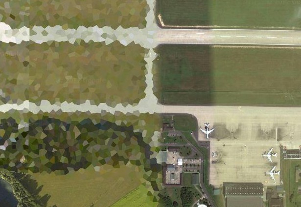 [ Google Maps ], [ Bing Maps ] [ Yandex.Maps ], [ Yahoo! Maps ]
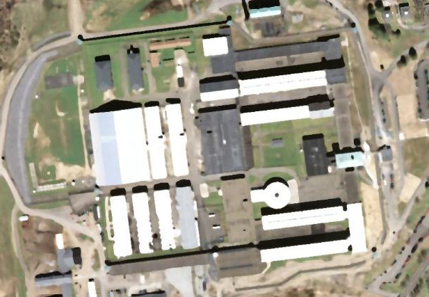
 - Port Liish high security prison .
One of the most reliably guarded prisons in Europe, located in Ireland. 24-hour security is armed with assault rifles and anti-aircraft machine guns, anti-tank ditches are dug around the prison, and it is equipped with various sensors. Prisoners are particularly dangerous Irish criminals, as well as serving a life sentence. 80% of prisoners have committed drug offenses. [ Google Maps ] [ Bing Maps ]
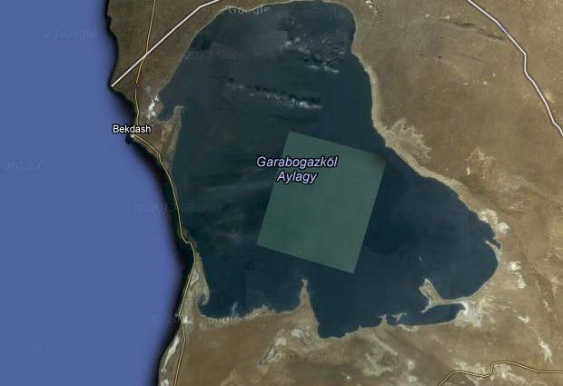
 - The bay of Kara-Bogaz-Gol (literally translated as “Black Lake”) is the lagoon-lagoon of the Caspian Sea in the west of Turkmenistan. One of the largest deposits of mirabilite .
 [ Google Maps ] [ Yandex.Maps ], [ Bing Maps ]
 - Electrical substation hydroelectric station in Gabcikovo , Slovakia.
She became the cause of the conflict between Slovakia and Hungary . At one time, Hungary and Slovakia agreed on the construction of a hydropower station on the Danube - near the cities of Nagymaros (Hungary) and Gabcikovo (Slovakia). Later, Hungary refused to build a hydroelectric power station on its territory because of the “green” protests, and Slovakia built a hydroelectric power station.
The substation is disguised as a field: one can see high-voltage power transmission lines going nowhere, as well as a road that suddenly ends near the “field”.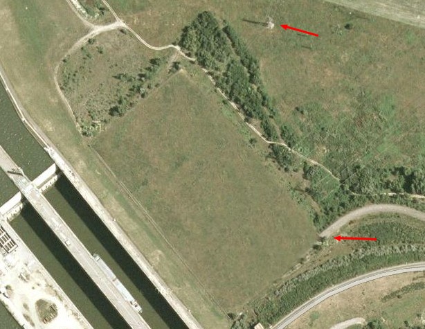 [ Google Maps ]
 - Millergof , Russia, Berezhki village, Moscow region.
Country cottage simple Russian multimillionaire Alexei Miller. Since the end of 2009 on Google Maps the object has been disguised as a regular field. One of the most famous places in Russia on satellite maps, along with a black rectangle in Chukotka .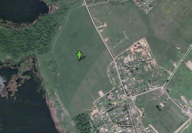 [ Google Maps ], [ Wikimapia ] [ Bing Maps ], [ Yandex.Maps ] for the link thanks Simba
 - High Security Prison and Highest Security Level Big Hill , USA, New York.
 [G oogle Maps ] [ Bing Maps ]
 - Nuclear Center Marcoult in France.
Here are located a non-operating nuclear power plant and a plant for the processing of radioactive waste. [ Google Maps ], [ Bing Maps ] [ Yahoo! Maps ]
 - Sagamore Bridge, Massachusetts, USA.
Connected to the highway to Boston.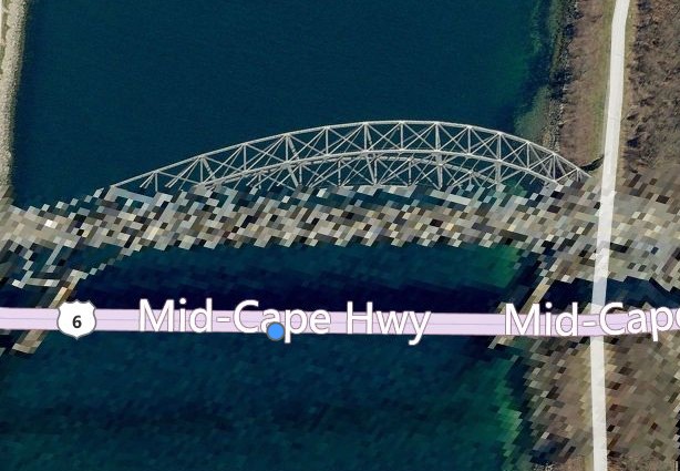 [ Bing Maps ] [ Google Maps ]
 - Sibruk NPP , USA, New Hampshire.
Long before the start of construction, local residents opposed the building, and after the start of construction, they tried in every possible way to prevent the construction of this nuclear power plant from continuing. From 1976 to 1989, more than 4,000 citizens were attracted for committing acts of civil disobedience on this issue. [ Google Maps ] [ Bing Maps ]
Such censorship is not always constant, there are many cases where the restriction on viewing was removed and previously hidden objects on satellite maps became fully visible for viewing.
Wikipedia has a page (in English) that lists the hidden locations on satellite maps by state.
To be continued...
Source: https://habr.com/ru/post/147197/
All Articles