5 years to satellites on Yandex.Maps
Five years have passed since the first satellite images appeared on Yandex.Maps . Once the addition of each new city was an event - now space photos cover the entire surface of the Earth. And more than 1,700 cities were photographed in such detail that even road markings can be seen in the photographs.
On this occasion, we decided to tell you in detail where the satellite images are taken from and how they fall on Yandex.Maps - and we prepared this text about it. You will learn which satellites are photographing the Earth, and trace the entire path of the image from orbit to the satellite layer on Maps.
There are four viewing modes (layers) on Yandex.Maps — a diagram , satellite images , a hybrid, and a folk map . The “Satellite” layer is images of the Earth from space. On it, a person can see how he looks from orbit, for example, his city, house or even a garage. On the basis of satellite images, users draw the People's map. Yandex specialists, when creating maps, also use space photos.
')
Before being on Yandex.Maps, satellite images are first transmitted from space orbit to Earth, and then go through several processing steps. It all starts with a satellite that photographs the surface of the globe.
What satellites are needed by Yandex
Satellites fly in orbit around the Earth. Some transmit television signals, the second determine the location of objects, and others perform other tasks. There are also Earth remote sensing devices (remote sensing of the Earth) - such satellites help in monitoring emergency situations, forecasting weather or yield. And, most importantly for Yandex.Maps, they know how to photograph the Earth.
For different territories, Yandex uses photographs of varying degrees of detail, depending on the population of the territories and their relevance to Yandex users. For example, detailed photographs of the Siberian forests are not needed very much, but Yekaterinburg or Vladivostok - on the contrary. And the coast of the Sea of Okhotsk is not as interesting to users as the Black.
For Russian and large foreign cities, Yandex acquires images with the highest resolution - from Ikonos, QuickBird and WorldView2 satellites. In such pictures you can see even the road markings.
The remaining territories were taken by other satellites. The European part of Russia - satellite IRS. In his pictures are clearly visible highways and high-rise buildings. And the remaining surface of the Earth is covered with photographs from the Landsat satellite, in which, at the maximum approximation, one can distinguish large objects such as airports or individual city blocks.

How to photograph a satellite
Satellites make photographs of the Earth by request, and do not remove everything. For example, Yandex needs fresh snapshots of N. In the order for the shooting of this city, Yandex marks the territory to be taken, and also indicates the image requirements - clear or cloudy weather, snowless season. Now, flying over the city of N, the satellite will photograph it.
The satellite does not photograph at night. If at the time of shooting in the right region they promise a lot of clouds, they also try not to take it off. However, the satellite itself cannot understand whether the resulting image meets the requirements of the customer. This will be determined after the satellite sends the images to Earth. If the photos do not meet the stipulated conditions, the satellite will continue to photograph. Some cities are very difficult to shoot, and sometimes it takes a long time to wait for good shots. For example, Pyatigorsk is almost never visible from space because of the dense layer of clouds. Or the Asbest satellite managed to take it off clearly only in the winter. And Yandex tries to use winter photos only in extreme cases, because all the objects on them are gray-white.
A space camera takes two photos of the same territory at once. Black and white, the most detailed, and color, with a lower resolution - due to the refraction of light in the earth's atmosphere, high-resolution color photographs from such a height cannot be made. Then the resulting images are combined. In digital form, a picture with a lower resolution is obtained a smaller image with a higher resolution. In order to combine images, a color image is stretched, which makes it even less clear, and is superimposed on black and white.
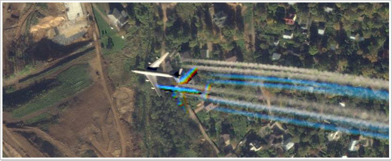
Black-and-white and color images are taken at intervals of a fraction of a second, therefore, the fast-moving objects in the combined images do not match the contours. This is noticeable in the photographs of the aircraft, if you bring the satellite layer as close as possible to the vicinity of an airport.
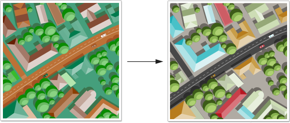
Original satellite images are different from ordinary photos, because space cameras perceive colors differently than earthly ones. The color is distorted due to the characteristics of the atmosphere, the height of the orbit on which the satellite is flying, and the technical capabilities of the cameras. To make the colors in the picture look natural, they make color correction.
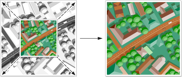
The satellite shoots at an angle, and some of the objects in the picture can be deformed - so you need to put a photo on the earth's relief map to compensate for the distortion.
Only after all these changes, the picture from space gets into Yandex.
Yandex is working on photos
Yandex received a snapshot of the city of N. The size of the snapshot depends on which satellite made it. Suppose it is 32000h32000 pixels weighing 3 GB. If the city is small, then it will fit in one such image. For example, for Novosibirsk, they need two, for Moscow - five, and for St. Petersburg with suburbs - six.
After receiving the image, Yandex imposes it on the corresponding section on the satellite layer of Maps and connects with its neighbors, so that, for example, the highway is not interrupted at the border of new and old images.
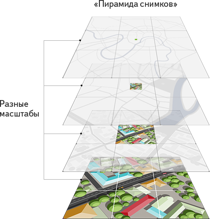
Multiple images are made from one - one for each of the scales. For the most detailed, the maximum resolution is left; for more general, they are correspondingly reduced, because the smaller the resolution of the image, the smaller the picture will weigh. The result is a “pyramid of images”, which the user will consistently see, bringing closer and distancing the satellite layer on Yandex.Maps.
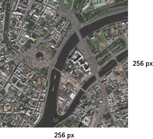
Then each image for each scale is divided into tiles - squares of 256x256 pixels. All layers on Yandex. Cards are loaded with just such tiles. This allows you to speed up the work of Yandex.Map - only those sites that the user is currently viewing are downloaded.
Finally a snapshot of the city N is ready for publication. As a rule, Yandex publishes new satellite images in whole releases, so fresh photos of the city N will appear on the satellite layer of Yandex.Map along with updates from other territories.
On this occasion, we decided to tell you in detail where the satellite images are taken from and how they fall on Yandex.Maps - and we prepared this text about it. You will learn which satellites are photographing the Earth, and trace the entire path of the image from orbit to the satellite layer on Maps.
There are four viewing modes (layers) on Yandex.Maps — a diagram , satellite images , a hybrid, and a folk map . The “Satellite” layer is images of the Earth from space. On it, a person can see how he looks from orbit, for example, his city, house or even a garage. On the basis of satellite images, users draw the People's map. Yandex specialists, when creating maps, also use space photos.
')
Before being on Yandex.Maps, satellite images are first transmitted from space orbit to Earth, and then go through several processing steps. It all starts with a satellite that photographs the surface of the globe.
What satellites are needed by Yandex
Satellites fly in orbit around the Earth. Some transmit television signals, the second determine the location of objects, and others perform other tasks. There are also Earth remote sensing devices (remote sensing of the Earth) - such satellites help in monitoring emergency situations, forecasting weather or yield. And, most importantly for Yandex.Maps, they know how to photograph the Earth.
For different territories, Yandex uses photographs of varying degrees of detail, depending on the population of the territories and their relevance to Yandex users. For example, detailed photographs of the Siberian forests are not needed very much, but Yekaterinburg or Vladivostok - on the contrary. And the coast of the Sea of Okhotsk is not as interesting to users as the Black.
For Russian and large foreign cities, Yandex acquires images with the highest resolution - from Ikonos, QuickBird and WorldView2 satellites. In such pictures you can see even the road markings.
The remaining territories were taken by other satellites. The European part of Russia - satellite IRS. In his pictures are clearly visible highways and high-rise buildings. And the remaining surface of the Earth is covered with photographs from the Landsat satellite, in which, at the maximum approximation, one can distinguish large objects such as airports or individual city blocks.
How to photograph a satellite
Satellites make photographs of the Earth by request, and do not remove everything. For example, Yandex needs fresh snapshots of N. In the order for the shooting of this city, Yandex marks the territory to be taken, and also indicates the image requirements - clear or cloudy weather, snowless season. Now, flying over the city of N, the satellite will photograph it.
The satellite does not photograph at night. If at the time of shooting in the right region they promise a lot of clouds, they also try not to take it off. However, the satellite itself cannot understand whether the resulting image meets the requirements of the customer. This will be determined after the satellite sends the images to Earth. If the photos do not meet the stipulated conditions, the satellite will continue to photograph. Some cities are very difficult to shoot, and sometimes it takes a long time to wait for good shots. For example, Pyatigorsk is almost never visible from space because of the dense layer of clouds. Or the Asbest satellite managed to take it off clearly only in the winter. And Yandex tries to use winter photos only in extreme cases, because all the objects on them are gray-white.
A space camera takes two photos of the same territory at once. Black and white, the most detailed, and color, with a lower resolution - due to the refraction of light in the earth's atmosphere, high-resolution color photographs from such a height cannot be made. Then the resulting images are combined. In digital form, a picture with a lower resolution is obtained a smaller image with a higher resolution. In order to combine images, a color image is stretched, which makes it even less clear, and is superimposed on black and white.
Black-and-white and color images are taken at intervals of a fraction of a second, therefore, the fast-moving objects in the combined images do not match the contours. This is noticeable in the photographs of the aircraft, if you bring the satellite layer as close as possible to the vicinity of an airport.
Original satellite images are different from ordinary photos, because space cameras perceive colors differently than earthly ones. The color is distorted due to the characteristics of the atmosphere, the height of the orbit on which the satellite is flying, and the technical capabilities of the cameras. To make the colors in the picture look natural, they make color correction.
The satellite shoots at an angle, and some of the objects in the picture can be deformed - so you need to put a photo on the earth's relief map to compensate for the distortion.
Only after all these changes, the picture from space gets into Yandex.
Yandex is working on photos
Yandex received a snapshot of the city of N. The size of the snapshot depends on which satellite made it. Suppose it is 32000h32000 pixels weighing 3 GB. If the city is small, then it will fit in one such image. For example, for Novosibirsk, they need two, for Moscow - five, and for St. Petersburg with suburbs - six.
After receiving the image, Yandex imposes it on the corresponding section on the satellite layer of Maps and connects with its neighbors, so that, for example, the highway is not interrupted at the border of new and old images.
Multiple images are made from one - one for each of the scales. For the most detailed, the maximum resolution is left; for more general, they are correspondingly reduced, because the smaller the resolution of the image, the smaller the picture will weigh. The result is a “pyramid of images”, which the user will consistently see, bringing closer and distancing the satellite layer on Yandex.Maps.
Then each image for each scale is divided into tiles - squares of 256x256 pixels. All layers on Yandex. Cards are loaded with just such tiles. This allows you to speed up the work of Yandex.Map - only those sites that the user is currently viewing are downloaded.
Finally a snapshot of the city N is ready for publication. As a rule, Yandex publishes new satellite images in whole releases, so fresh photos of the city N will appear on the satellite layer of Yandex.Map along with updates from other territories.
Source: https://habr.com/ru/post/144954/
All Articles