Spb Transport Online
After the city public transport portal of St. Petersburg was launched, and the GLONASS / GPS monitoring systems were installed on the transport itself, it became possible what you could only dream of - having come to the bus stop, see where the bus is right now we wait.
And “right now” is not just a turn of speech, not an exaggeration. Transport and truth is displayed on the map in real time. Of course, I mean a map on a mobile device.
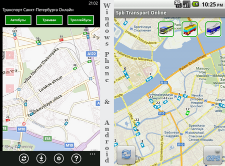
The free program “Spb Transport Online” exists in two versions - for Android and Windows Phone. Despite the different interface, they are very similar in terms of ease of use - we launch, GPS determines where we are, and use the buttons to select the type of transport you need. The result on the picture above (clickable). Buses are blue, trolley buses are green, and trams are red.
Spb Transport Online will help you - now you will know exactly where the transport you need is and save a bunch of nerve cells.
')
The principle of operation of the program is based on obtaining the physical size of the part of the map displayed on the screen and the geographical coordinates of the map corners. Based on this data, a request is made to the server and in response a transparent png is obtained with the display of the transport position on the selected map section. The size of the picture for the screen 240x320 is about 10 kilobytes. It should be noted that the picture contains only one type of transport and if all three types are included, then three images are requested, i.e. 30 kilobytes of traffic for a total of one update. Next, the resulting picture is superimposed on the map. Taking into account the fact that the superimposed image is strictly according to the size of the map, then with each shift of the map, with zooming, there are additional requests to the server to update the image depending on the geographical coordinates of the corners of the map.
Given this approach, it is not possible to isolate any particular route, but in the next versions I plan to do a search for routes and display stops on the map, route, schedule for stops.
Referred to public transport portal
Spb Transport Online on Google Play
"Spb Transport Online" in the Marketplace
New versions will be here (do not do the same post on Habré every time)
And “right now” is not just a turn of speech, not an exaggeration. Transport and truth is displayed on the map in real time. Of course, I mean a map on a mobile device.
The free program “Spb Transport Online” exists in two versions - for Android and Windows Phone. Despite the different interface, they are very similar in terms of ease of use - we launch, GPS determines where we are, and use the buttons to select the type of transport you need. The result on the picture above (clickable). Buses are blue, trolley buses are green, and trams are red.
Examples of the use of the program
- You are standing at the bus stop at 12 at night and waiting for the tram. Do trams run at such times? And if they should, was there at least one tram on the line? After all, it may happen that the last tram broke down and went to the park.
- You are late for work, but the desired trolleybus is still not there. Catch a bus or wait for more?
- Rush hour, comes full of a busy bus. Try to cram in or wait for the next one? Suddenly he is very close?
Spb Transport Online will help you - now you will know exactly where the transport you need is and save a bunch of nerve cells.
')
Some technical details
The principle of operation of the program is based on obtaining the physical size of the part of the map displayed on the screen and the geographical coordinates of the map corners. Based on this data, a request is made to the server and in response a transparent png is obtained with the display of the transport position on the selected map section. The size of the picture for the screen 240x320 is about 10 kilobytes. It should be noted that the picture contains only one type of transport and if all three types are included, then three images are requested, i.e. 30 kilobytes of traffic for a total of one update. Next, the resulting picture is superimposed on the map. Taking into account the fact that the superimposed image is strictly according to the size of the map, then with each shift of the map, with zooming, there are additional requests to the server to update the image depending on the geographical coordinates of the corners of the map.
Given this approach, it is not possible to isolate any particular route, but in the next versions I plan to do a search for routes and display stops on the map, route, schedule for stops.
useful links
Referred to public transport portal
Spb Transport Online on Google Play
"Spb Transport Online" in the Marketplace
New versions will be here (do not do the same post on Habré every time)
Another couple of moments
- In the discussion on w3bsit3-dns.com, the question sounded several times - whether there will be a version for iPhone. No, it will not. I do not have an iPhone :) But if anyone wants to make and any questions arise - write, help, than I can. Although all the necessary information is in the paragraph about the technical nuances.
- Whether there will be a version for Windows Mobile - it will probably be, but I do not promise.
Source: https://habr.com/ru/post/143229/
All Articles