OpenStreetMap for every day
On the OSM Habre is constantly mentioned, only the project’s reputation seems to be completely none: a handful of people program something, draw some lines and relationships, fight for license purity. But in fact, the project is completely different: to give everyone a map with which you can do anything: the same Google Maps, the same Yandex.Maps, but which, if desired, can be corrected or downloaded to a mobile device.
Therefore, I want to talk about the basics: how did these cards replace Yandex with me in almost all everyday tasks?
View and search
For a Russian-speaking participant, the project has two entry points: openstreetmap.org (also osm.org ) and openstreetmap.ru ( osm.org.ru ). They have a large map and search string. These sites differ in the list of layers: there are much more of them in Russian, including the most beautiful MapSurfer.NET, satellite images from Bing, three-dimensional houses and feedback (“indicate inaccuracy on the map”, then double-click anywhere). The second difference is the search mechanism.
')
On openstreetmap.org, the search works at addresses in the Western style: house number, street, city (for example, “24, Nevsky Prospect, St. Petersburg”). Abbreviations do not work, throwing out the status part (write “Nevsky” instead of “Nevsky Prospect”) or add it (“Kuzmolovo village” instead of “Kuzmolovo”) is undesirable. But there is a POI search (points of interest: shops, cafes, hairdressers, cinemas, etc.) and by category names (“cafes near Nevsky Prospect,” cases also do not work). In short, a good search, but not adapted to Russian requests.

They tried to fix this on openstreetmap.ru: most addresses from different sites can be inserted there, and they will be processed correctly. Actually, 90% of my calls to Yandex.Maps were like a search engine by addresses, and now our site has replaced it. From bonuses - for the project of election commissions I used the API of our search engine (openstreetmap.ru/api/search?q = Jaz), and he found almost all addresses in Petersburg (written, I note, in free form).
Another 9% of calls to maps are searching for a place with “eyes”: opening a site, reducing the scale to the entire planet, then approaching the right place in three or four jumps by stretching the rectangle with the mouse with Shift held. After getting used to scaling a rectangle, the sites of Google and Yandex suddenly become terribly inconvenient. I note that openstreetmap.ru is also not very convenient, because there is no scale bar, and you have to press the "minus" button a hundred times.
Share
Illustrate the coordinates or address in three ways. The first is to make a screenshot of the map. The second is to give a link to a fragment of the map. On openstreetmap.org for this, there are two types of links at the bottom right: long (for articles) and short (throw in the chat). The first has an obvious and readable structure, the second does not break the screen.
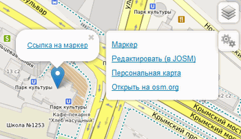 On openstreetmap.ru is a permanent link at the bottom left, but besides this, you can clearly mark the point that we are talking about with a marker: this word is hidden in the icon with gears on the right.
The most advanced way is to place a live map with markers on the page and with what not. Manually it is easy to make a library Leaflet , but you can be lazy and use the tool recommended for information sites of the European Union.
Measure and draw
The distance measurement tool on the Yandex map is often used to draw routes: the line is there, and its length is shown, and the link is easy to get. In OpenStreetMap these are two different tools. So, for distance measurement there is a separate site Distance Calculator . He even gives the distance in two coordinate systems. And allows you to save the drawn path in gpx. Oh wait ...
Drawing routes for others - in Show Your Journey . Although it is suggested to register there everywhere, it is necessary only to edit your routes, but to make a new one is simple: at the bottom right, the “Start a route” button, then draw (or load GPX), then enter a name and poke into “Create”.
Finally, recently on the openstreetmap.ru toolbar appeared item "Personal Card". This is an adequate substitute for drawing labels and broken lines on Yandex maps. True, the interface is not so beautiful, and the information is not enough, so if the map allows, it is still easier to draw broken lines in Yandex.
Lay the route
Oh, it's just a grail in custom cartography. Each card seller has its own engine, OpenStreetMap has a dozen of them. For a quick calculation of distances, I can not deny myself the pleasure of using Project OSRM : its speed is amazing. Pull the marker - and the route is rebuilt in real time. Alas, it works only in Europe and the European part of Russia. There is a good chance that this engine will soon be launched in full force on openstreetmap.org.
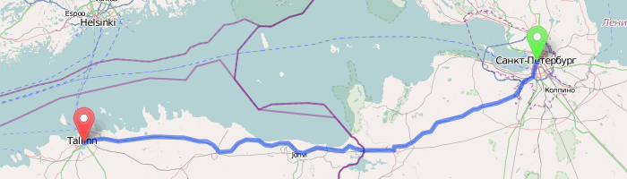
For more complex routing, with via points and the choice of transport, I use the Cloudmade service . Besides it, there is OpenRouteService and YourNavigation.org : all three have their drawbacks, the first and third are also updated regularly, but the final choice is made for convenience: their functionality is about the same, and all are better than commercial alternatives, especially at long distances. Would use a beautiful MapQuest , but I just can not get it.
Take with you
The method of the XX century: print! There are many sites, the most obvious one is Walking Papers . If you are going to spend several days in an unfamiliar city, Maposmatic makes a kind of atlas with a street index.

But we will be more technological. Even carrying with you gigabytes of pumped out tiles is the last century. The advantage of OpenStreetMap is the availability of raw data. Vector maps on phones with J2ME shows GpsMid , on ah * ah - MapsWithMe , and for androids the best application is OsmAnd + (there is a free version, also Habropost ). In the latter, directly from the program, you can download map assemblies for the desired areas and countries, plus add different POI layers. For example, in the last journey we hooked up a layer of Wikipedia articles, and while I was driving, my wife read descriptions of the places where we were passing.
Real tourists, of course, spit on the newfangled devices and use individual navigators. Data uploads are available for almost any system: Navitel , City Guide , PocketGis , GissRuss . But most of all unloading for Garmin, because everyone has their own purpose. The three most popular in Russia: automotive and two tourist: from ValentinAK and from Max Vasilyev . For trips abroad, welcome to the buffet .
Use and supplement

Something at the end of the article slipped into the list of links. Well, okay: in our awkward wiki , I confess, to find something useful is not easy, especially after the raid of grafomanov-wikipedists. On the other hand, we have already gone beyond the boundaries of the functionality of the “big” cards on offline use, and at the same time, the most beautiful applications of this OSM were left out of frame. And what really strikes you is that all these sites, services, uploads, routing work with the same data that can be corrected or supplemented by each. What we do every day. Use our map - and maybe someday you will want to fix some little thing. So they get stuck.
The article uses FakeSteveC comics, OpenStreetMap map snapshots in osm.org, MapSurfer.net and Stamen Design tiles, as well as a photo of kachkaev .
Source: https://habr.com/ru/post/142129/
All Articles