2GIS for PC: more volume and new colors (beta)
We are pleased to inform you that we are starting beta testing of the new version of the desktop 2GIS. This important technological release includes a new mapping engine, providing not only better performance, but also a much more attractive look. And also, now 2GIS cards are truly three-dimensional!
The goals for which we lay out this release in public access are to get feedback and identify possible problems (if found), and also provide an opportunity for developers of 2GIS plug-ins to test them for compatibility with the new version of 2GIS and make the necessary changes. Read more about this on the plugin developers forum .
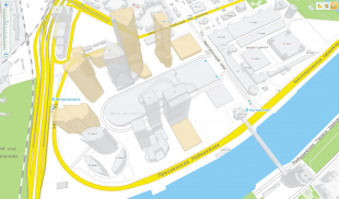
So 2GIS looked earlier:

')
And so it will look now:

The most noticeable change is, of course, that now 2GIS renders a map in three-dimensional form, and the models of buildings correspond to real prototypes. When the map approaches / moves away, the 3D mode is turned on at about the street scale.
In addition, a number of activities were carried out to improve the perception of the map. Those who previously used 2GIS for different cities, will notice that now all the cards are made in a new uniform color scheme, in soft and fresh colors. Similar colors could already be seen in the mobile version of 2GIS for the iPhone. We continued to work on visual accents, trying to highlight the most important objects (settlements, districts, streets, individual buildings) on each map scale.
“Rotate the camera” in the beta version is not possible, but this feature is planned for the next releases. This feature will allow you to avoid the inconvenience associated, for example, with the need to click on a small extension to the building, which may overlap with a large main building.
In addition, we are working on displaying the fonts that sign the streets on the map. While they are not perfect, but, we hope, later they will become such (or almost so). Also add some visual effects when moving the map.
In the beta version, the search for directions is disabled - both by car and by public transport, but this functionality will definitely be present in the final version. In addition, the names of metro stations will be displayed directly on the map. Previously, in order to find out the name, you had to click on the station icon.
The final version of the update is scheduled for May 1, 2012, and until that time we hope to receive information from you about your impressions. The beta version of 2GIS with three-dimensional maps of cities can be downloaded here , and suggestions and comments can be sent to desktop.beta@2gis.ru (or write in the comments to this post) - we will be happy to receive feedback.
The goals for which we lay out this release in public access are to get feedback and identify possible problems (if found), and also provide an opportunity for developers of 2GIS plug-ins to test them for compatibility with the new version of 2GIS and make the necessary changes. Read more about this on the plugin developers forum .
So, what's new can be seen in 2GIS now?
So 2GIS looked earlier:
')
And so it will look now:
The most noticeable change is, of course, that now 2GIS renders a map in three-dimensional form, and the models of buildings correspond to real prototypes. When the map approaches / moves away, the 3D mode is turned on at about the street scale.
In addition, a number of activities were carried out to improve the perception of the map. Those who previously used 2GIS for different cities, will notice that now all the cards are made in a new uniform color scheme, in soft and fresh colors. Similar colors could already be seen in the mobile version of 2GIS for the iPhone. We continued to work on visual accents, trying to highlight the most important objects (settlements, districts, streets, individual buildings) on each map scale.
About what is not in this version yet, and what will appear in it
“Rotate the camera” in the beta version is not possible, but this feature is planned for the next releases. This feature will allow you to avoid the inconvenience associated, for example, with the need to click on a small extension to the building, which may overlap with a large main building.
In addition, we are working on displaying the fonts that sign the streets on the map. While they are not perfect, but, we hope, later they will become such (or almost so). Also add some visual effects when moving the map.
In the beta version, the search for directions is disabled - both by car and by public transport, but this functionality will definitely be present in the final version. In addition, the names of metro stations will be displayed directly on the map. Previously, in order to find out the name, you had to click on the station icon.
The final version of the update is scheduled for May 1, 2012, and until that time we hope to receive information from you about your impressions. The beta version of 2GIS with three-dimensional maps of cities can be downloaded here , and suggestions and comments can be sent to desktop.beta@2gis.ru (or write in the comments to this post) - we will be happy to receive feedback.
Source: https://habr.com/ru/post/139554/
All Articles