Google Transit: The Quiet Revolution in Public Transport
Among the many projects of Google there is one very important project, which the company has been engaged for more than five years, and at the same time it is surprisingly little covered in the press. We are talking about the GTFS standard (originally Google Transit Feed Specification, but since 2009, decoding was changed to the General Transit Feed Specification) - a general protocol for the public transport schedule, which Google proposed in 2006.
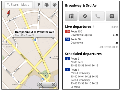
Now Google receives information from 475 US and European transport companies, but so far the schedule on Google Maps only works in four American cities (Boston, Portland, San Diego, San Francisco) and two European (Madrid, Turin). Residents of these cities can see in the familiar Google Maps interface how many minutes the desired bus, trolleybus or tram will arrive at the stop - the Live Transit Updates function works on these cities since June 2011, that is, a real-time update of information on the real location of transport.
The service is so convenient and useful that it can not be overestimated - no more waiting at the bus stop, you can calculate the route around the city, taking into account any transfers and always feel confident in any unfamiliar place of the city. What can I say, for the first time you can ride on public transport even in a foreign city, where you came as a tourist! Previously, tourists only walked on foot or took a taxi, but now it’s enough to get a smartphone - and the program will tell you where to stop and which bus to take.
')
In general, Google has made a real revolution in the field of public transport, writes Xconomy, and this is not an exaggeration.
Other companies have attempted to do something similar before: the very first attempt to aggregate the public transport timetable dates back to 1994, when students at the University of California opened Transitinfo.org. And now there are similar mobile applications (for example, Embark covers eight US cities and London), but thanks to Google, a single format for feeds with schedules has appeared, and these files are laid out in open access.
GTFS is an open standard that anyone can use. These are simple format files. For example, here are the first lines of a file published by the transport company TriMet.
See GTFS format specifications .
The entire TriMet file is 169 MB in size. This is raw data that you can use in any way. A list of companies that publish a schedule in GTFS format, as well as their GTFS feeds are published on the GTFS Data Exchange website (350 transport companies). Now all developers of applications for working with public transport schedules use GTFS, and this format has already become the de facto standard in its field.
For real-time updates, the GTFS-realtime format is proposed , it provides for monitoring each bus using GPS and constantly publishing fresh coordinates online.
Now Google receives information from 475 US and European transport companies, but so far the schedule on Google Maps only works in four American cities (Boston, Portland, San Diego, San Francisco) and two European (Madrid, Turin). Residents of these cities can see in the familiar Google Maps interface how many minutes the desired bus, trolleybus or tram will arrive at the stop - the Live Transit Updates function works on these cities since June 2011, that is, a real-time update of information on the real location of transport.
The service is so convenient and useful that it can not be overestimated - no more waiting at the bus stop, you can calculate the route around the city, taking into account any transfers and always feel confident in any unfamiliar place of the city. What can I say, for the first time you can ride on public transport even in a foreign city, where you came as a tourist! Previously, tourists only walked on foot or took a taxi, but now it’s enough to get a smartphone - and the program will tell you where to stop and which bus to take.
')
In general, Google has made a real revolution in the field of public transport, writes Xconomy, and this is not an exaggeration.
Other companies have attempted to do something similar before: the very first attempt to aggregate the public transport timetable dates back to 1994, when students at the University of California opened Transitinfo.org. And now there are similar mobile applications (for example, Embark covers eight US cities and London), but thanks to Google, a single format for feeds with schedules has appeared, and these files are laid out in open access.
GTFS is an open standard that anyone can use. These are simple format files. For example, here are the first lines of a file published by the transport company TriMet.
  trip_id, arrival_time, departure_time, stop_id, stop_sequence, stop_headsign, pickup_type, drop_off_type, shape_dist_traveled, timepoint
 2666662,08: 53: 00,08: 53: 00,13170,1,45th Ave, 0,0,0.0,1
 2666662,08: 54: 26,08: 54: 26,7631,2,45th Ave, 0,0,877.4,0
 2666662,08: 56: 31,08: 56: 31,7625,3,45th Ave, 0,0,2163.1,0
See GTFS format specifications .
The entire TriMet file is 169 MB in size. This is raw data that you can use in any way. A list of companies that publish a schedule in GTFS format, as well as their GTFS feeds are published on the GTFS Data Exchange website (350 transport companies). Now all developers of applications for working with public transport schedules use GTFS, and this format has already become the de facto standard in its field.
For real-time updates, the GTFS-realtime format is proposed , it provides for monitoring each bus using GPS and constantly publishing fresh coordinates online.
Source: https://habr.com/ru/post/138871/
All Articles