OpenStreetMap to help cyclists
Introduction
Imagine that it is summer, the sun is shining, you have a vacation, and you and your friends are avid cyclists. There is a thought about cycling somewhere far away. In this article I will talk about how OpenStreetMap technologies and some other services simplify life in such a situation, solve planning problems and allow you to quickly and simply share your impressions. The emphasis is on online, I mention resources:
- Openstreetmap
- OpenCycleMap
- OpenRouteService
- ShowYourJourney
- Draft Map of Russia
- MapOSMatic
- Web interface to GPSBabel
- CourseMapper
- GPS Visualizer
Trip planning
So, at some bicycle forum or from your friends you will find out that place X is simply super, every self-respecting cyclist is obliged to go there and in general it is not clear why you haven’t been there yet. If X is completely unfamiliar to you, then questions arise:
Where is X?
The official site of OpenStreetMap , despite the Spartan asceticism, allows out of the box to look for settlements, places, etc. Nominatim will also be useful, which is “sharpened” specifically for the search.What is the best way to get there?
The first place to look, if you are not living in Russia - OpenCycleMap . This is a special map for cyclists with cycling routes. The routes, I would say, are global and are not designed for local easy 8-hour walks. |
| OpenCycleMap Map. In Russia, it is not popular at all. |
')
OpenRouteService
Excellent German site, by default, opens in German, but on the right from the top it has the coveted English flag. Click on the Start line, then on the point of departure on the map, then on the End line, then on the destination point on the map, and finally, on the Calculate button. The result will appear pretty quickly, incl. cumulative distance and turn "200 meters turn right". You can find routes for cars, pedestrians and cyclists. For the first and last options, unique options are available, the meaning of which is clear from the name, but just in case it has been repeatedly tested empirically. For a car, there is a choice between the fastest and the shortest way, because the shortest can be winding or with a bunch of traffic lights and other troubles. For pedestrians, the shortest path is sought, using paths, footpaths, sidewalks, etc., carefully applied by OpenStreetMap cartographers.For cyclists, the settings are especially rich: the shortest path / shortest track , the safest path / safest track (avoid big roads), for the road bike / racer (on the contrary, try to make a route on the roads), for the mountain bike / mountain bike (similar to the safest, apparently, added tortuosity). In addition to the listed options, the algorithm can be additionally configured (more options), in particular, manually enable the option of avoiding highways and tramways, as well as highlight polygons on the map through which it is impossible to pass / pass. The result can be exported to a link with parameters inside or to standard GPX. In general, German developers deserve respect, especially since the OpenRouteService has an impressive list of scientific publications available (in the INFO & CONTACT section).
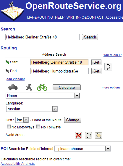 | 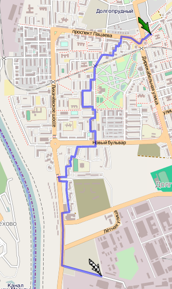 |
| OpenRouteService settings. | Avoiding highways in the OpenRouteService cycling route. |
ShowYourJourney
The longer the route from OpenRouteService, the greater the likelihood that it does not work well somewhere, and the person would do it better. ShowYourJourney allows you to load the GPX route to you and fix it with your hands. However, you can create a route from scratch. Successfully implemented work with the track - each link can always be divided in half in the middle. To start, click on “start a route” on the bottom right. Of course, the result can be re-exported to GPX.ShowYourJourney is similar to GPS Visualizer Freehand Drawing Utility , but you cannot import data there.
 |
| Interface Show your journey. |
Where to get maps for navigator?
Now I want to save the map with the route in the navigator (if you have one). You can download the OpenStreetMap maps on the wiki of the Map of Russia project , and with the loading of GPX in the navigator, I think, there will be no problems.How to prepare a printed version of the map?
Navigators are unreliable (for example, the battery quickly sits down), and their screen is small due to portability. A good practice is to take a paper printed card. The official website of OpenStreetMap, although it allows you to print, will come out to you, to put it mildly, a bit small. For high-quality printing, MapOSMatic exists. Simply set the rectangle with the mouse, clamping Control, and forward. The service supports export to SVG and raster, conveniently splits the map into squares and creates an index. How to automate map printing with our route using OpenStreetMap is an open question. I think Maperitive can handle it offline . Also, nothing prevents the use of GPSVisualizer.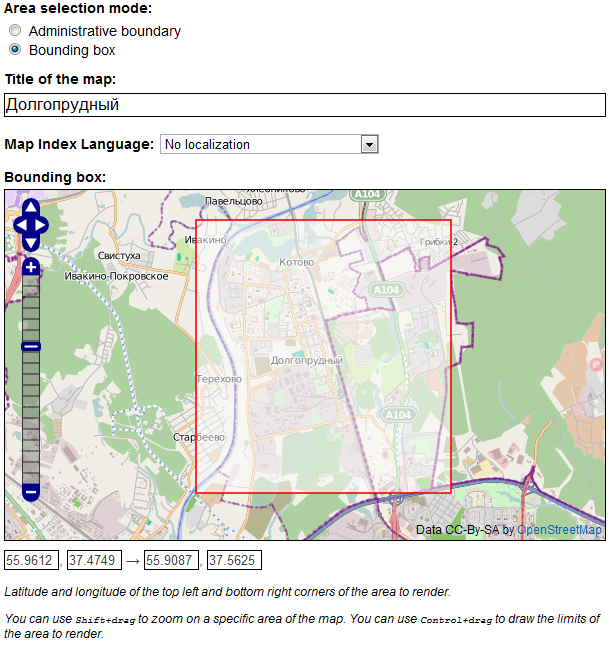 |
| MapOSMatic at work. |
Trip visualization
You successfully traveled to X and returned safely. All the time your trip navigator or tracker carefully recorded your way. Somewhere the roads were blocked and you made a detour, somewhere the community OpenStreetMap screwed up and put the path through an impassable swamp and again had to focus on the place, somewhere made a hook for the POI, in general - the track does not match the "reference" . And I want to share my impressions with friends, colleagues and relatives! It is necessary to visualize the track. Again, in order:How to overtake my track from the "native" format ??? in digestible GPX?
Many interested people know about the wonderful gpsbabel , which knows absolutely everything about track formats. An online version of this program is available, which does exactly the same thing. We load our track into the web interface, download GPX (you can even in a zip-archive).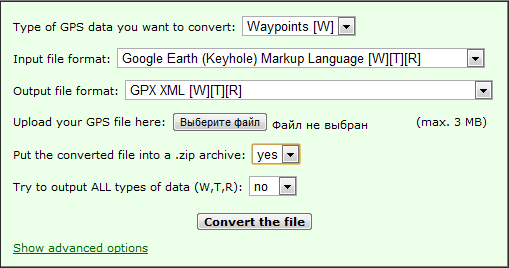 |
| Web interface to GPSBabel from GPS Visualizer |
How to optimize the track?
It's no secret that the track recording function of the navigators is implemented in the same way - a mindless machine simply remembers your position at a specified time interval. As a result, the tracks take megabytes after 12 hours, and the services that work with them are not childishly tense. Information in the "raw" tracks is redundant: if you drove all the time in a straight line, the internal points can be thrown out with a clear conscience. Also, at the sites, the GPS “sausage” and there is a “Brownian movement” around the true position.To solve this problem, there is CourseMapper . Unfortunately, it is built on the basis of Google Maps and the OpenStreetMap substrate cannot be made in it, but it can load a track directly from Garmin devices, and, of course, it is friendly with GPX. In its settings, you can select the minimum accuracy in meters and the version of the algorithm (speed vs. quality). Service is thoughtful on large amounts of data. If your track is very large, then it remains either to cut into pieces and then glue the optimized ones, or use offline solutions. Optimization greatly reduces the size of the track, depending on the settings and data up to 1000 times.
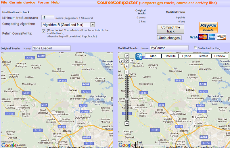 |
| Commander-like CourseMapper. |
How cool and beautiful to show the track?
This is a "clean" visualization, better quality than ShowYourJourney. If you are too lazy to reinvent the wheel yourself, my advice to you is to use GPS Visualizer . It’s just a very sophisticated and free visualization service, powerful and flexible, with its own community and wiki. I will only list the especially "tasty" features:- Simultaneous display of multiple tracks. Conveniently, if your companion meets you halfway, and your tracks are different.
- Import from GPX.
- Export to raster and vector. Export an interactive map to HTML (using Google Maps).
- In the interactive map, you can customize the default substrate, whether it is OpenStreetMap or Google satellite imagery.
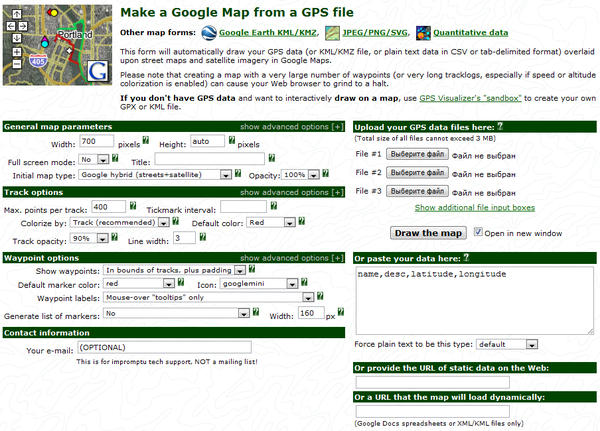 |
| The abundance of GPS settings Vizualizer. |
 |
| Display at once two tracks on an interactive map. |
As a conclusion
Not for nothing at the State of the Map (SotM) 2011 OpenStreetMap conference was compared to Linux - there is a total Linux way to work with maps and tracks. No site does all the work completely, and you achieve your goal by collecting a solution from independent pieces. Maybe someday, there will be a startup that will get rid of the above-mentioned zoo from online services, but so far everything is much more interesting. I really hope that you have learned something interesting and useful from this article.
PS
And yes I will be forgiven for the tabular layout of pictures.Source: https://habr.com/ru/post/131466/
All Articles