Raid on Saransk: how in one weekend to make a map of the whole city
A week ago, I mentioned that the OpenStreetMap participants first staged an “online mapping party” and drew a Bing satellite map for one weekend map of Saransk , the capital of Mordovia. Now let's summarize.
In addition to a humorous report (highly recommended) and a serious report , a good video about the last event was also made (thanks to the trolleway ). It shows the process of improving the city map, a “pie” map, where participants' areas of responsibility, a coordination page , a comparison of panoramic photos of the city and a three-dimensional image based on OpenStreetMap data (it looks very impressive), and a record of the navigator’s work were noted. And all this with good music. Watch all:
')
And all this drawing was started to help the bus13.ru transport monitoring site , which suddenly began to use the OpenStreetMap card at the time when it was not very good yet. The site found OldIvantey , and offered to draw a city osmisto . As a result, the event turned out to be not just using bus13.ru, but also a good test of the strengths of the OpenStreetMap community and success in drawing the whole city.
As I understand it, the locals from this were in joyful shock and now several people from Saransk (ZhenDos, SVE, x15, p3omat, MIR, TemikNT, JOHN, Nickolay, ArtCore) joined the community of OpenStreetMap and they began to notice bugs that allowed ponae ... "run" participants, and mark the POI.
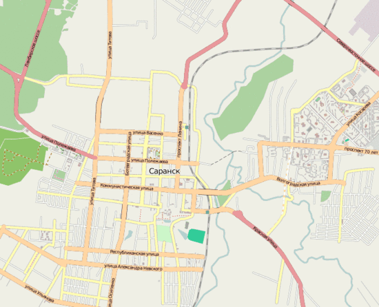
Once again you can compare the map here: it was , it became .
But the animation:
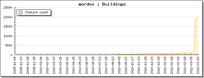
And this is how it was reflected in the statistics:
The list of participants who recently ruled Mordovia, can be found here .
Meanwhile, participants are already making plans for the future . The purpose of the next raid may be Gelendzhik.
In addition to a humorous report (highly recommended) and a serious report , a good video about the last event was also made (thanks to the trolleway ). It shows the process of improving the city map, a “pie” map, where participants' areas of responsibility, a coordination page , a comparison of panoramic photos of the city and a three-dimensional image based on OpenStreetMap data (it looks very impressive), and a record of the navigator’s work were noted. And all this with good music. Watch all:
')
And all this drawing was started to help the bus13.ru transport monitoring site , which suddenly began to use the OpenStreetMap card at the time when it was not very good yet. The site found OldIvantey , and offered to draw a city osmisto . As a result, the event turned out to be not just using bus13.ru, but also a good test of the strengths of the OpenStreetMap community and success in drawing the whole city.
As I understand it, the locals from this were in joyful shock and now several people from Saransk (ZhenDos, SVE, x15, p3omat, MIR, TemikNT, JOHN, Nickolay, ArtCore) joined the community of OpenStreetMap and they began to notice bugs that allowed ponae ... "run" participants, and mark the POI.
Once again you can compare the map here: it was , it became .
But the animation:
And this is how it was reflected in the statistics:
The list of participants who recently ruled Mordovia, can be found here .
Meanwhile, participants are already making plans for the future . The purpose of the next raid may be Gelendzhik.
Source: https://habr.com/ru/post/115978/
All Articles