OpenStreetMap News №3
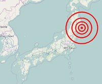
- Japan ! Many buildings destroyed, flooded, displaced, many roads littered with debris and so on and so forth. All this needs to be mapped, which, I think, local residents and rescuers will be able to use ( as once in Haiti - OSM members then performed a real feat, here is a beautiful video ). For this project, (hurray !!!) were provided with fresh satellite images of DigitalGlobe and JAXA / ALOS , where the consequences of the disaster are visible and everyone from all over the world is invited to describe them. And the Japanese themselves will mark on the spot the sources of water, working shops, telephones and so on.
- For the first time, the Russian community together, dividing the city into areas of responsibility, remotely draws on the basis of satellite images ( progress is seen here ) Saransk , the capital of
Mordor inMordovia. Previously, one city was already drawn together, but this was not done remotely, but right on the spot - the participants came to Velikie Luki and made a first-class map of the city . - From July 15 to July 17, 2011, the first European Conference of State of the Map will be held in Vienna , dedicated to OpenStreetMap . This is the closest conference venue to Russia, so don’t miss your chance to see live OSM enthusiasts from across Europe. For other conferences see here .
- As you know, osm.org has not only the basic style of drawing maps using Mapnik (which was created by a certain Artyom Pavlenko ), but also Osmarender , which is generated not by servers in London, but by the method of distributed computing on users' computers and this project called Tiles @ home . So it seems that this project, unfortunately, is becoming a thing of the past. Quote from SHTOSM : “The administrator Sebastian Spaeth about a month ago summarized five years of development of the project and admitted that now no one has a desire to engage and develop this business, so we can assume that the time T @ H is gone. The server will continue to work on its own - until something thoroughly breaks, or new distributed computing enthusiasts appear with their server (access to the existing one is limited). So, given the number of volunteers, we can expect that a cover will come to the Osmarender layer during this year. ”
- Began work All-Russian address validator . Look for errors in familiar places and fix them!
')
Source: https://habr.com/ru/post/115348/
All Articles