Latest GarminASUS A50
The history of cooperation between companies that do not need to be represented by ASUS and Garmin began relatively recently - in 2009, although the first negotiations were still back in 2008. Despite the crisis, the companies began to work quite tightly, resulting in a lineup consisting of 4 devices at the moment. In their names, I noticed a small pattern - devices with Windows Mobile start with " M " (M10, M20), and devices on Android OS - with " A " (A10, A50).
Today we will talk about the fresh Garmin ASUS A50 - it is much more attractive than that, but I consider its price one of the main advantages - from 10 thousand rubles.
Network : EDGE / GPRS / GSM (850/900/1800/1900 MHz), UMTS (1700/2100 MHz), HSDPA (7.2 Mbit / s, 384 Kbps)
Display : 3.5-inch TFT-display (480x320, HVGA) with a capacitive touch interface, 262 thousand colors
Operating system : Android 2.1 (Eclair)
Processor : Qualcomm 7227, 600 MHz
Video accelerator : ATI Imageon Z430
Memory : 256 MB (RAM) + 256 MB (ROM), 4 GB of flash memory
Slot for memory cards : microSD (with support for SDHC-cards up to 32 GB)
Interfaces : Bluetooth 2.0 + EDR, USB 2.0, 802.11b / g
GPS : Qualcomm GPSOne - Gen7 (with AGPS support)
Camera : 3 megapixel with autofocus
Battery capacity : 1150 mAh
Standby time : up to 18 days
Talk time : up to 9 hours
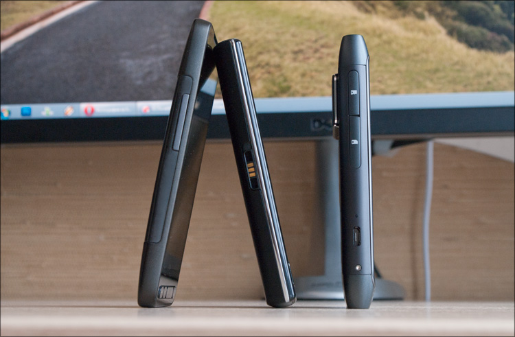
Dimensions : 58x110x13.8 mm
Weight : 130 g (with battery)
')
This is the second device from Garmin ASUS, which I used to use ... and the equipment was once again pleasantly pleased. The first model pampered the second battery and three interchangeable panels in the box, which in this case is not ... but it is inappropriate to complain here - even with much more expensive devices they often put much less. So:
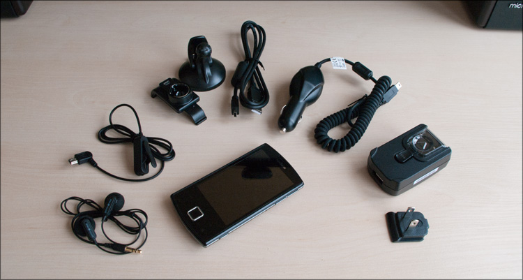
- Communicator Garmin ASUS A50
- User's manual
- Wired stereo headset
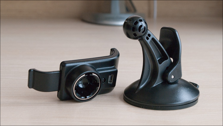
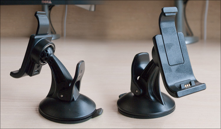
- Car mount (on glass)
- Car charger (from cigarette lighter)
- Adapter for charging the phone
- Euro plug for charging
- USB-miniUSB wire
- Battery
This is what was in my box. But when you buy, you also get a 2 GB memory card, a special disk for mounting the device on the “torpedo” of the car and one useful piece of paper with a key from ... Navitel Navigator! You heard right, Navitel will also be included with the Garmin device!
Everything is explained quite simply. At the moment, Garmin is very popular and is one of the best navigation solutions ... but, unfortunately, not in all regions and, in particular, not in Russia. Navitel is much more popular here, which, according to a recent study, has more than 70% of the market. Accordingly, it is much more profitable to sell devices that will satisfy a wider range of users - such a communicator-navigator is suitable not only for Russia, but also for any other country!
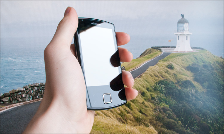
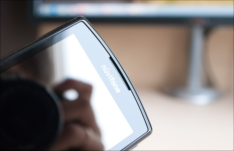
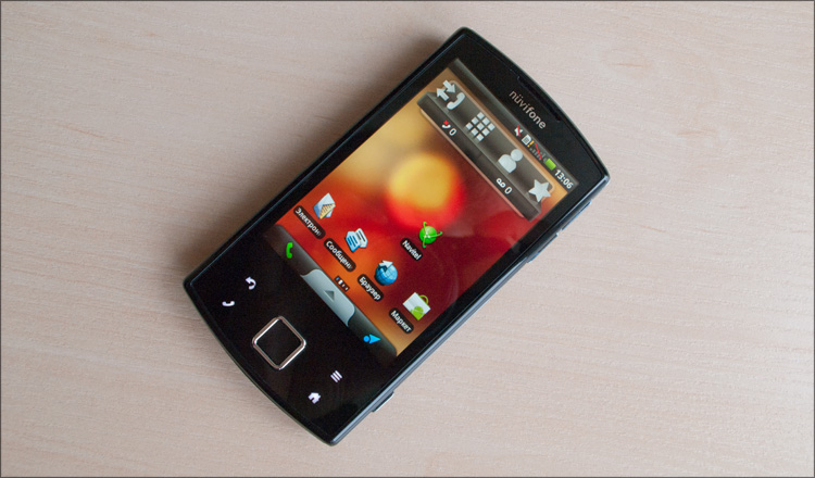
Three-quarters of the front surface area is occupied by a screen that is hidden under the glass. At the very top is a tiny speaker, and at the bottom there is a 4-position key with a button inside. I also found out about the four buttons (sides of the center) later when I turned on the device for the first time - they glow with white light, but almost cannot be seen without the backlight.

On the sides - unsigned keys, which are clearly highlighted in relief. In principle, whoever had dealt with communicators, would easily guess about their functions - volume control and camera. Also on the sides there are functional elements for installing the phone in the car mount - on the right there is a small recess, and on the left - three contacts, thanks to which the device will be charged during movement.
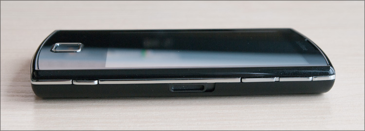
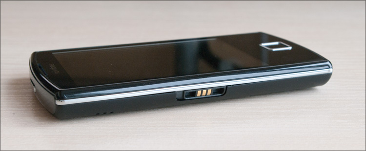
Below is a miniUSB connector and a microphone, and on the top is a power button, which also includes the display during operation.


Actually, I’m more used to it when the display power button is on the side of the communicator ... but here I’m used to it pretty quickly, all the more you can find this location (when first connected in the car) a logical explanation - when the device is fixed on the windshield, the button is not will have to search among the fastening elements. Installing the phone in the car mount automatically activates a constant backlight and speakerphone, and disconnecting from the cradle automatically remembers the coordinates (parking) and returns all settings back.
The reverse side is one large plastic cover, the outer side of which is covered with a pleasant to the touch rubberized material. At the top center there is a camera eye (without a flash), a slot opposite the speaker and a metal insert on which the letters Garmin ASUS are printed. This inscription is also metallic and in the dark with any light source it gives a pleasant glow, due to which it becomes similar to the inscription from the LCD screen.
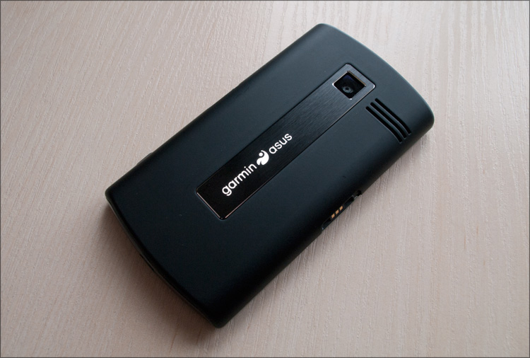

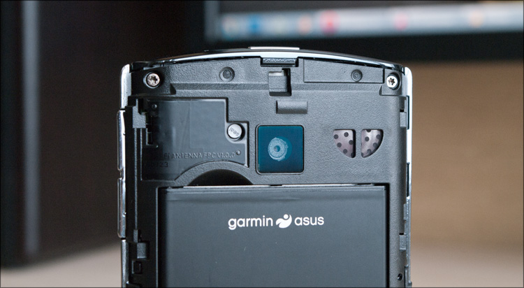
The cover is removed by shifting down, under it is a lithium-ion battery (1150 mAh, 3.7 V, 4.255 Wh) with 4 contacts. There is a special cutout in the case for pulling out the battery, although it is not clear what it is for - the SIM card slot and the slot for a memory card (microSD format) are below and even when the battery is installed, are available at any time.

In appearance, you can recognize the whole assortment of elements of other devices, but in general it turned out to be a fairly independent design and, importantly, very attractive. Looking at the Garmin ASUS A50, I most of all remember the Acer Liquid , but here everything is assembled much better, on the conscience - the details fit perfectly, the lid sits very tightly. Without the slightest hint of backlash, squeaks and other assembly shoals - as it should be.
At the moment, there is quite a bit of information on this device on the network - on the same w3bsit3-dns.com in a specially created topic it is still unusually empty - there are no alternative builds and firmware up to Android 2.2, and only recently I learned how to get root) I hope that all this is still ahead, and I have nothing left but to write about what was at the time of the test.
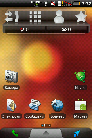
The first thing that catches the eye when booting the operating system (which takes about 30 seconds) is a redesigned interface. I have seen various improvements - somewhere, icons just changed and unnecessary widgets were added ... somewhere much more extensive work was done. Here is both, but it is clear that efforts have been made. All icons are licked - this is noticed on the desktop, and later in the main menu. Over the usual menu also worked - in the aggregate, everything looks very harmonious.
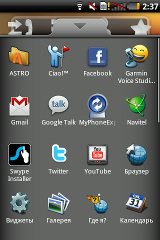
Initially, there are 4 virtual desktops, the leftmost of which, as I said, is set aside for navigation. On the rest there is nothing superfluous - the player, search and basic icons. This is not HTC Sense with 7 tables, which sometimes do not even know what to score. In general, I really liked the interface, even despite the bright red wallpaper by default - everything is somehow calm and unobtrusive.
A few words about navigation. On the main desktop is the Navitel icon - if you click on it, then in a few seconds a full-fledged Navitel Navigator under Android will appear, in appearance no different from the versions for other OS (unlike the same Town). Accordingly, it also works in the same way - there is nothing to add.
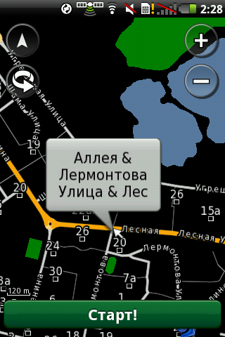
Interestingly continues on the “navigation desktop”, where there are three items - “Contacts” (to go to the address book), “Overview of places” (allows you to find any POIs around) and “Map view” (map view, where you can choose any place and start moving to it. Also, there is a universal address bar above them - you can drive in any address or object and the search results will appear on the map soon. If you enter the desired address in the search line, the map will immediately open and you can start moving about the created route . On the point, whether you go by car or walking There is a function display tubes, operating through Yandex - here you need to cook a ruble, which will go for the transmission of data in the background.
In the survey of places, as before, there are many categories with subcategories - ATMs, transport, leisure, shops, cafes, intersections of the necessary streets, coordinates - everything is there! And this surprised me - even in my small town near Moscow, the program knew where the post office was, where was the gas station and car service, where was the sports club ... and not only displayed it on the map - you could even see the contact numbers of the organizations! It was the same in Moscow, but there were always more objects there - it turned out that in addition to McDonald’s Pushkin there are a hundred more places to eat :) You can choose the kitchen you want ... and the search results will be sorted by distance to the desired object further only "sel paehal." The appearance of the map is quite flexible, multitouch works on it, and the whole animation (zoom, turns, angle of view change) occurs smoothly even if there are many three-dimensional objects on the map.

By the way, in the system settings, you can choose a different desktop theme, which appears on various photos and videos on the network. I will not describe in detail, but just note that for cars this option will be more suitable.

At this goodies do not end. The main menu is the application Panoramio, after the launch of which on the screen there are thumbnails of many photos (made by someone once), related to your current location. Just watch what you think is interesting ... and if you want, you can click on the photo and go / go to this place along the paved route. This is great in that you can visually select the desired object, which may not be labeled on the map itself! Well, for example, in the summer half of Moscow comes to our city for a career - do not enter the “career” in the navigator) And here you see a photo and more, in fact, you don’t need to do anything. But it should be understood that this is not the most specialized function - rather, so, entertainment.


By the way, the camera of this communicator is able to overlay geographic data on images, so you don’t have to remember when, and most importantly, where the photos were taken.
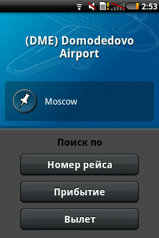
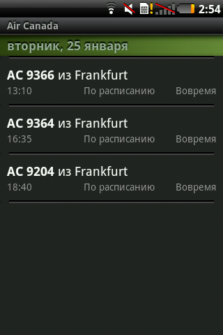
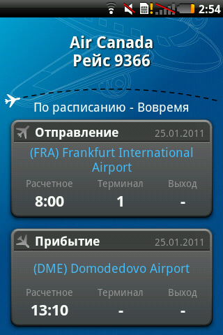
There is detailed information not only on land transport - there is a program in the menu for viewing information on air travel. Go, select the airport (from those around) and then you can search by flight number, arrival or departure. You can also look at the airline - select the desired flight and the screen immediately displays what, when, from where and at which terminal it will land, or what, from where and where it will fly.

Plus, there is at least the fact that all of this is rather deeply integrated into the shell of the Android OS, that is, it is always available and at any time - no need to wait for the programs to start. I do not have to wait long for satellites either — I don’t know, maybe this is somehow connected with the constantly open “geo” inlay, or the sky was always cloudless ... but there were never any problems with catching satellites.
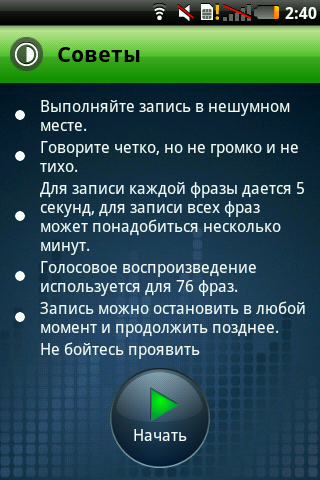
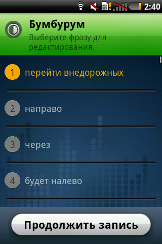
In addition to the pre-created phrases, the navigator is able to synthesize speech for the pronunciation of streets along which the movement is carried out - thanks to this, the size of all the data for navigation is not so great. Another interesting feature of the GarminASUS A50 is the ability to create your own sound theme for your navigator. Run the program - it gives a list of 76 phrases that need to be spoken into the microphone. We spend all this for some time, but at the output we get our own, unique and obviously working sound theme. Can you imagine how surprised my wife would be if during the trip she would hear her son's voice from the navigator? :) Flight for imagination is.
The external speaker seemed to me not very loud, but you will not miss the call with it; the same goes for shakes. But with the volume of conversational dynamics in general, a full order. I couldn't get used to switching profiles in any way - holding the power button meant only turning off the device, so I just changed the volume depending on the situation.
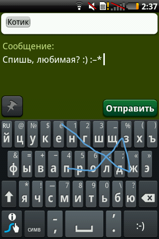
The capacitive screen is quite colorful (although this is a TFT and there are “only” 262 thousand colors in it) and juicy, the brightness is enough even in the sun - just in case there is a switchable brightness control sensor. The screen diagonal is 3.5 inches, and the resolution - 320x480; The viewing angles are slightly less than 180 degrees, which makes it possible to see the image on the screen almost always. Initially, in my copy of the device, there was no Russian on the keyboard - I added it (instead of the standard keyboard), putting Swype; On beta.swype.com without any problems found the HVGA-version of the program. The Russian keyboard appeared in firmware 5.0.75, to which I advise you to upgrade immediately after purchasing the device.
The three-megapixel camera takes pretty good pictures, I have not tried to write a video to it.


Connecting to a computer standard - for synchronization, as a removable media or modem.
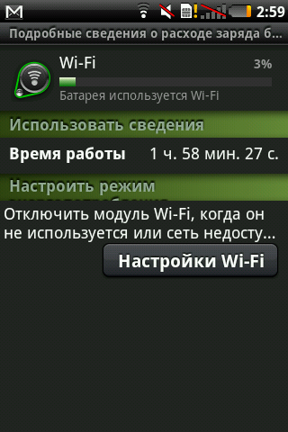
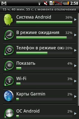
On the same charge with my inactive mode of use (with periodic short-term charging from the cigarette lighter in the car), the device easily worked for a week. But in a more active mode, the battery will sit down faster - after two or three days. In the settings there is an interesting page for displaying the use of various device modes - there you can see there as a percentage what the phone is used for.
There are a lot of system settings - I don’t want to inflate the post to inedible sizes, so I suggest that all those interested in getting to know the internals on their own - I tried to make more screenshots of the interface.
By the way, a special thank you to the hardware camera button, which can be zabindit without any ruts for creating screenshots - without this function, I would surely suffer with photo processing.
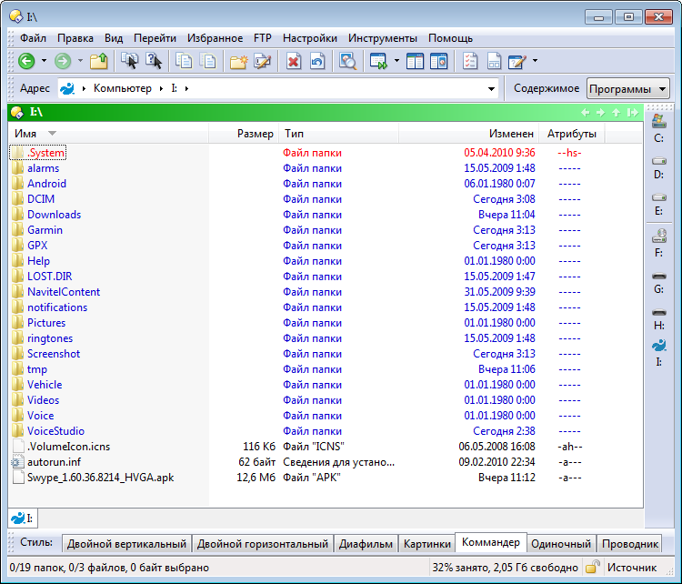
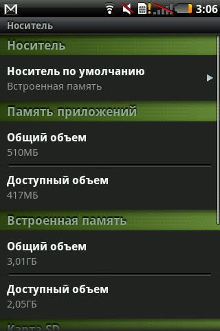
The amount of internal memory for installing applications is 256MB, which should be enough even for the most redundant soft-arsenal. Another 4GB of flash-memory is set aside for data storage - pictures there, video, and so on. Well, to whom this will not be enough, you can put a microSD memory card with a maximum capacity of no more than 32 GB. It is noteworthy that the removed battery cover blocks access to data on removable media, protecting information from potential damage.
 Good equipment, car mount
Good performance, large memory, bright screen
Stylish appearance, practical case material; miniUSB instead of microUSB
Two navigation programs, deep integration of navigation software into the device
Quickly catches satellites
Price
 No hole for attaching the strap and 3.5mm headphone jack
While there is only Android 2.1
Camera without flash
Until recently, the recommended retail price for a new product was 12,990 rubles, and only Svyaznoy exclusively sold them (as much as a thousand more). But today, you can find this communicator from 10,500 rubles.
Looking at this phone, I am pleased with the symbiosis of Garmin and ASUS - it is clear that they do not pursue technological primacy in the phone market, preferring to devote time to work on the quality of the software component of the device. But at the same time, I am a little sad - because at the end of January, the existence of this wonderful alliance ended; Approximately from March, the A50 will be released exclusively under the ASUS brand. But it is reassuring that the companies did not quarrel and did not say goodbye finally - most likely there will still be “joint”, but, apparently, already under the ASUS brand. Whatever it was, they managed to “inherit” these two companies, and quite successfully - the GarminASUS A50 that I mentioned was definitely a success, the price / quality ratio still needs to be searched.
Finally I want to say a few words about Navitel. At the official announcement of the Garmin ASUS A50 at the end of January there were representatives of all the companies related to this device. Danil Zharikov (Navitel Commercial Director) spoke about the company's work and plans for the near future.
At the moment, for the navigation software Navitel, the most common platform is, oddly enough, Windows Mobile - it is for her that everything is done in the first place. And recently, a new version of Navigator has been released for this platform, with the number 5.0. The main trump card of this version is “extremely fast routing”, that is, high-speed routing. At this moment I was not too lazy to get the phone and make a small video:
As you can see, the route of 9500+ kilometers was laid in just 3 seconds, and this was done on the maximum map detail - through the secret streets of provincial cities, taking into account all the specifics, etc. Accordingly, routes throughout Moscow are built generally in a split second. As far as I understand, all routes are simply cached, I cannot find another explanation yet ... nevertheless, a very pleasant innovation. But it is much more pleasant that this version will be available for PNA devices and devices on other platforms, such as Android and iOS, for a month!
Otherwise, the main focus now are all sorts of online services, since the function “get from point A to point B” is no longer so competitive. Traffic jams, weather, the menu of the nearest restaurants, gasoline prices at some gas stations, social networks and connections - without details, but work is in full swing over all of this.
Everything that has already been done and that is only planned to be implemented will also be available for the A50, so the navigation potential will only increase with time.
Today we will talk about the fresh Garmin ASUS A50 - it is much more attractive than that, but I consider its price one of the main advantages - from 10 thousand rubles.
Specifications
Network : EDGE / GPRS / GSM (850/900/1800/1900 MHz), UMTS (1700/2100 MHz), HSDPA (7.2 Mbit / s, 384 Kbps)
Display : 3.5-inch TFT-display (480x320, HVGA) with a capacitive touch interface, 262 thousand colors
Operating system : Android 2.1 (Eclair)
Processor : Qualcomm 7227, 600 MHz
Video accelerator : ATI Imageon Z430
Memory : 256 MB (RAM) + 256 MB (ROM), 4 GB of flash memory
Slot for memory cards : microSD (with support for SDHC-cards up to 32 GB)
Interfaces : Bluetooth 2.0 + EDR, USB 2.0, 802.11b / g
GPS : Qualcomm GPSOne - Gen7 (with AGPS support)
Camera : 3 megapixel with autofocus
Battery capacity : 1150 mAh
Standby time : up to 18 days
Talk time : up to 9 hours
Dimensions : 58x110x13.8 mm
Weight : 130 g (with battery)
')
Equipment
This is the second device from Garmin ASUS, which I used to use ... and the equipment was once again pleasantly pleased. The first model pampered the second battery and three interchangeable panels in the box, which in this case is not ... but it is inappropriate to complain here - even with much more expensive devices they often put much less. So:
- Communicator Garmin ASUS A50
- User's manual
- Wired stereo headset
- Car mount (on glass)
- Car charger (from cigarette lighter)
- Adapter for charging the phone
- Euro plug for charging
- USB-miniUSB wire
- Battery
This is what was in my box. But when you buy, you also get a 2 GB memory card, a special disk for mounting the device on the “torpedo” of the car and one useful piece of paper with a key from ... Navitel Navigator! You heard right, Navitel will also be included with the Garmin device!
Everything is explained quite simply. At the moment, Garmin is very popular and is one of the best navigation solutions ... but, unfortunately, not in all regions and, in particular, not in Russia. Navitel is much more popular here, which, according to a recent study, has more than 70% of the market. Accordingly, it is much more profitable to sell devices that will satisfy a wider range of users - such a communicator-navigator is suitable not only for Russia, but also for any other country!
Appearance
Three-quarters of the front surface area is occupied by a screen that is hidden under the glass. At the very top is a tiny speaker, and at the bottom there is a 4-position key with a button inside. I also found out about the four buttons (sides of the center) later when I turned on the device for the first time - they glow with white light, but almost cannot be seen without the backlight.
On the sides - unsigned keys, which are clearly highlighted in relief. In principle, whoever had dealt with communicators, would easily guess about their functions - volume control and camera. Also on the sides there are functional elements for installing the phone in the car mount - on the right there is a small recess, and on the left - three contacts, thanks to which the device will be charged during movement.
Below is a miniUSB connector and a microphone, and on the top is a power button, which also includes the display during operation.
Actually, I’m more used to it when the display power button is on the side of the communicator ... but here I’m used to it pretty quickly, all the more you can find this location (when first connected in the car) a logical explanation - when the device is fixed on the windshield, the button is not will have to search among the fastening elements. Installing the phone in the car mount automatically activates a constant backlight and speakerphone, and disconnecting from the cradle automatically remembers the coordinates (parking) and returns all settings back.
The reverse side is one large plastic cover, the outer side of which is covered with a pleasant to the touch rubberized material. At the top center there is a camera eye (without a flash), a slot opposite the speaker and a metal insert on which the letters Garmin ASUS are printed. This inscription is also metallic and in the dark with any light source it gives a pleasant glow, due to which it becomes similar to the inscription from the LCD screen.
The cover is removed by shifting down, under it is a lithium-ion battery (1150 mAh, 3.7 V, 4.255 Wh) with 4 contacts. There is a special cutout in the case for pulling out the battery, although it is not clear what it is for - the SIM card slot and the slot for a memory card (microSD format) are below and even when the battery is installed, are available at any time.
In appearance, you can recognize the whole assortment of elements of other devices, but in general it turned out to be a fairly independent design and, importantly, very attractive. Looking at the Garmin ASUS A50, I most of all remember the Acer Liquid , but here everything is assembled much better, on the conscience - the details fit perfectly, the lid sits very tightly. Without the slightest hint of backlash, squeaks and other assembly shoals - as it should be.
Turn on and work
At the moment, there is quite a bit of information on this device on the network - on the same w3bsit3-dns.com in a specially created topic it is still unusually empty - there are no alternative builds and firmware up to Android 2.2, and only recently I learned how to get root) I hope that all this is still ahead, and I have nothing left but to write about what was at the time of the test.
The first thing that catches the eye when booting the operating system (which takes about 30 seconds) is a redesigned interface. I have seen various improvements - somewhere, icons just changed and unnecessary widgets were added ... somewhere much more extensive work was done. Here is both, but it is clear that efforts have been made. All icons are licked - this is noticed on the desktop, and later in the main menu. Over the usual menu also worked - in the aggregate, everything looks very harmonious.
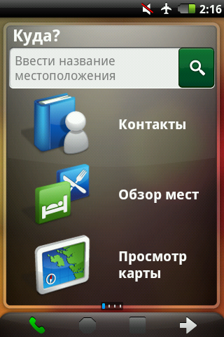
Initially, there are 4 virtual desktops, the leftmost of which, as I said, is set aside for navigation. On the rest there is nothing superfluous - the player, search and basic icons. This is not HTC Sense with 7 tables, which sometimes do not even know what to score. In general, I really liked the interface, even despite the bright red wallpaper by default - everything is somehow calm and unobtrusive.
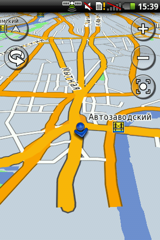
A few words about navigation. On the main desktop is the Navitel icon - if you click on it, then in a few seconds a full-fledged Navitel Navigator under Android will appear, in appearance no different from the versions for other OS (unlike the same Town). Accordingly, it also works in the same way - there is nothing to add.
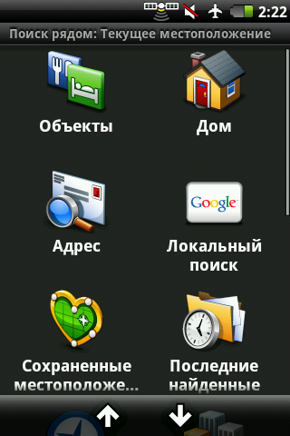
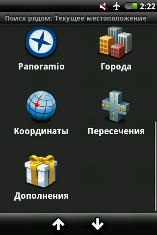
Interestingly continues on the “navigation desktop”, where there are three items - “Contacts” (to go to the address book), “Overview of places” (allows you to find any POIs around) and “Map view” (map view, where you can choose any place and start moving to it. Also, there is a universal address bar above them - you can drive in any address or object and the search results will appear on the map soon. If you enter the desired address in the search line, the map will immediately open and you can start moving about the created route . On the point, whether you go by car or walking There is a function display tubes, operating through Yandex - here you need to cook a ruble, which will go for the transmission of data in the background.
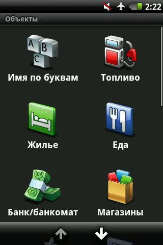
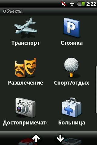
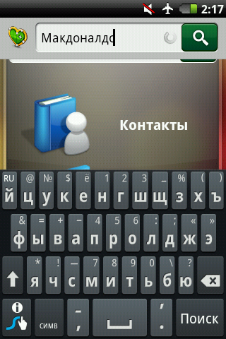
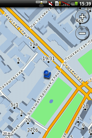
In the survey of places, as before, there are many categories with subcategories - ATMs, transport, leisure, shops, cafes, intersections of the necessary streets, coordinates - everything is there! And this surprised me - even in my small town near Moscow, the program knew where the post office was, where was the gas station and car service, where was the sports club ... and not only displayed it on the map - you could even see the contact numbers of the organizations! It was the same in Moscow, but there were always more objects there - it turned out that in addition to McDonald’s Pushkin there are a hundred more places to eat :) You can choose the kitchen you want ... and the search results will be sorted by distance to the desired object further only "sel paehal." The appearance of the map is quite flexible, multitouch works on it, and the whole animation (zoom, turns, angle of view change) occurs smoothly even if there are many three-dimensional objects on the map.
By the way, in the system settings, you can choose a different desktop theme, which appears on various photos and videos on the network. I will not describe in detail, but just note that for cars this option will be more suitable.
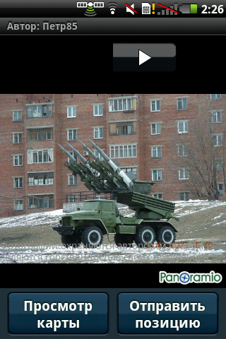
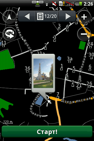
At this goodies do not end. The main menu is the application Panoramio, after the launch of which on the screen there are thumbnails of many photos (made by someone once), related to your current location. Just watch what you think is interesting ... and if you want, you can click on the photo and go / go to this place along the paved route. This is great in that you can visually select the desired object, which may not be labeled on the map itself! Well, for example, in the summer half of Moscow comes to our city for a career - do not enter the “career” in the navigator) And here you see a photo and more, in fact, you don’t need to do anything. But it should be understood that this is not the most specialized function - rather, so, entertainment.
By the way, the camera of this communicator is able to overlay geographic data on images, so you don’t have to remember when, and most importantly, where the photos were taken.
There is detailed information not only on land transport - there is a program in the menu for viewing information on air travel. Go, select the airport (from those around) and then you can search by flight number, arrival or departure. You can also look at the airline - select the desired flight and the screen immediately displays what, when, from where and at which terminal it will land, or what, from where and where it will fly.
Plus, there is at least the fact that all of this is rather deeply integrated into the shell of the Android OS, that is, it is always available and at any time - no need to wait for the programs to start. I do not have to wait long for satellites either — I don’t know, maybe this is somehow connected with the constantly open “geo” inlay, or the sky was always cloudless ... but there were never any problems with catching satellites.
In addition to the pre-created phrases, the navigator is able to synthesize speech for the pronunciation of streets along which the movement is carried out - thanks to this, the size of all the data for navigation is not so great. Another interesting feature of the GarminASUS A50 is the ability to create your own sound theme for your navigator. Run the program - it gives a list of 76 phrases that need to be spoken into the microphone. We spend all this for some time, but at the output we get our own, unique and obviously working sound theme. Can you imagine how surprised my wife would be if during the trip she would hear her son's voice from the navigator? :) Flight for imagination is.
The external speaker seemed to me not very loud, but you will not miss the call with it; the same goes for shakes. But with the volume of conversational dynamics in general, a full order. I couldn't get used to switching profiles in any way - holding the power button meant only turning off the device, so I just changed the volume depending on the situation.
The capacitive screen is quite colorful (although this is a TFT and there are “only” 262 thousand colors in it) and juicy, the brightness is enough even in the sun - just in case there is a switchable brightness control sensor. The screen diagonal is 3.5 inches, and the resolution - 320x480; The viewing angles are slightly less than 180 degrees, which makes it possible to see the image on the screen almost always. Initially, in my copy of the device, there was no Russian on the keyboard - I added it (instead of the standard keyboard), putting Swype; On beta.swype.com without any problems found the HVGA-version of the program. The Russian keyboard appeared in firmware 5.0.75, to which I advise you to upgrade immediately after purchasing the device.
The three-megapixel camera takes pretty good pictures, I have not tried to write a video to it.
Connecting to a computer standard - for synchronization, as a removable media or modem.
On the same charge with my inactive mode of use (with periodic short-term charging from the cigarette lighter in the car), the device easily worked for a week. But in a more active mode, the battery will sit down faster - after two or three days. In the settings there is an interesting page for displaying the use of various device modes - there you can see there as a percentage what the phone is used for.
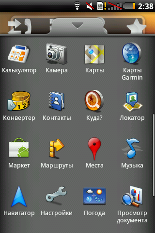
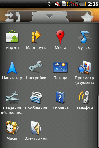
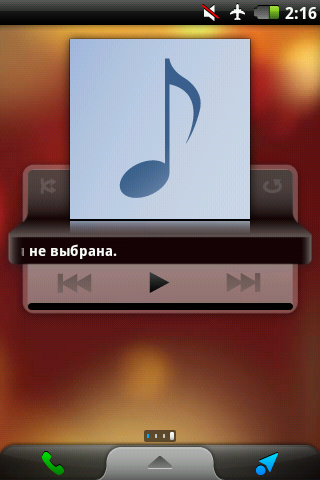
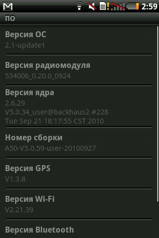
There are a lot of system settings - I don’t want to inflate the post to inedible sizes, so I suggest that all those interested in getting to know the internals on their own - I tried to make more screenshots of the interface.
By the way, a special thank you to the hardware camera button, which can be zabindit without any ruts for creating screenshots - without this function, I would surely suffer with photo processing.
The amount of internal memory for installing applications is 256MB, which should be enough even for the most redundant soft-arsenal. Another 4GB of flash-memory is set aside for data storage - pictures there, video, and so on. Well, to whom this will not be enough, you can put a microSD memory card with a maximum capacity of no more than 32 GB. It is noteworthy that the removed battery cover blocks access to data on removable media, protecting information from potential damage.
 Advantages and disadvantages
Good equipment, car mount Good performance, large memory, bright screen Stylish appearance, practical case material; miniUSB instead of microUSB Two navigation programs, deep integration of navigation software into the device Quickly catches satellites Price No hole for attaching the strap and 3.5mm headphone jack While there is only Android 2.1 Camera without flashUntil recently, the recommended retail price for a new product was 12,990 rubles, and only Svyaznoy exclusively sold them (as much as a thousand more). But today, you can find this communicator from 10,500 rubles.
The end
Looking at this phone, I am pleased with the symbiosis of Garmin and ASUS - it is clear that they do not pursue technological primacy in the phone market, preferring to devote time to work on the quality of the software component of the device. But at the same time, I am a little sad - because at the end of January, the existence of this wonderful alliance ended; Approximately from March, the A50 will be released exclusively under the ASUS brand. But it is reassuring that the companies did not quarrel and did not say goodbye finally - most likely there will still be “joint”, but, apparently, already under the ASUS brand. Whatever it was, they managed to “inherit” these two companies, and quite successfully - the GarminASUS A50 that I mentioned was definitely a success, the price / quality ratio still needs to be searched.
Finally I want to say a few words about Navitel. At the official announcement of the Garmin ASUS A50 at the end of January there were representatives of all the companies related to this device. Danil Zharikov (Navitel Commercial Director) spoke about the company's work and plans for the near future.
At the moment, for the navigation software Navitel, the most common platform is, oddly enough, Windows Mobile - it is for her that everything is done in the first place. And recently, a new version of Navigator has been released for this platform, with the number 5.0. The main trump card of this version is “extremely fast routing”, that is, high-speed routing. At this moment I was not too lazy to get the phone and make a small video:
As you can see, the route of 9500+ kilometers was laid in just 3 seconds, and this was done on the maximum map detail - through the secret streets of provincial cities, taking into account all the specifics, etc. Accordingly, routes throughout Moscow are built generally in a split second. As far as I understand, all routes are simply cached, I cannot find another explanation yet ... nevertheless, a very pleasant innovation. But it is much more pleasant that this version will be available for PNA devices and devices on other platforms, such as Android and iOS, for a month!
Otherwise, the main focus now are all sorts of online services, since the function “get from point A to point B” is no longer so competitive. Traffic jams, weather, the menu of the nearest restaurants, gasoline prices at some gas stations, social networks and connections - without details, but work is in full swing over all of this.
Everything that has already been done and that is only planned to be implemented will also be available for the A50, so the navigation potential will only increase with time.
Source: https://habr.com/ru/post/113328/
All Articles