Android in space!
This is a free translation on the theme of the flight of android into space.
For Google and for us, this is a very important study. It is well known that some of our favorite products provide an opportunity to explore the world in a new, impossible from this point of view. Google Maps - allows you to find the right way around the world. Google Earth - helps to explore our planet in detail, including forests and oceans. And using Google Sky Map on your Android, you can easily watch the starry sky. Therefore, we wanted to conduct an entertaining study in the upper atmosphere using devices with Android.
')
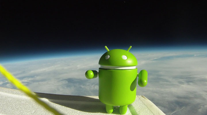
We recently traveled to the small town of Yon (Ione), in Kalifonia, and launched seven devices into the stratosphere that can withstand high loads. Taking advantage of the experience of those guys who have already carried out such tests at home, we completed our weather probe with a Nexus S phone so that we could get data from telephone sensors - GPS, gyroscope, accelerometer and magnetometer. It was also a great way to spend a good weekend. Having launched weather probes, we got amazing pictures and videos of the Earth. Take a look at Android from a height of more than 30 kilometers:
Well, firstly, the Android platform installed on the Nexus S smartphone, providing a robust development environment and a large set of built-in sensors, made it easy to write the applications needed for this project. In close cooperation with a student from the University of California, Santa Cruz, Greg Klein, we prepared each of the devices, placing them in special containers, securely attaching a radar reflector, a parachute, and the weather probe itself to it.

To transmit the location, we used the APRS protocol, since we know that it works well at high altitudes. The rest of the payload was different for each weather probe. We installed cameras on some of them, while on other cameras we tried to place all the instruments at different viewing angles.

On smartphones, we launched various applications:
We even installed astronauts on the manned devices - Android robots. See how we prepared and launched our weather probes:
Our devices transmitted numerous telemetric data to the ground, and some of them managed to reach considerable height. The highest altitude we have achieved is 107375 feet (32.7 km.), Which is three times the height to which commercial airlines usually fly. The highest speed, which was recorded - 139 miles (223 km.) Per hour.
While tracking the sensors on each of the phones, we found that the GPS in the Nexus S can function up to a height of about 60,000 feet (18 km) and starts working again when the vehicle is being lowered. We also saw that this phone can withstand rather severe ambient temperatures (up to -50˚). Here are some interesting data collected by us:
Analyzing all the data, we were able to detect some interesting trends. For example, we determined the speed and height of air currents: about 130 miles (209 km.) Per hour at an altitude of 35,000 feet (10.6 km).
You can watch the video of test launches here . For more information and photos, as well as a diagram of flight paths, see the official website android.hibal.org
For Google and for us, this is a very important study. It is well known that some of our favorite products provide an opportunity to explore the world in a new, impossible from this point of view. Google Maps - allows you to find the right way around the world. Google Earth - helps to explore our planet in detail, including forests and oceans. And using Google Sky Map on your Android, you can easily watch the starry sky. Therefore, we wanted to conduct an entertaining study in the upper atmosphere using devices with Android.
')
We recently traveled to the small town of Yon (Ione), in Kalifonia, and launched seven devices into the stratosphere that can withstand high loads. Taking advantage of the experience of those guys who have already carried out such tests at home, we completed our weather probe with a Nexus S phone so that we could get data from telephone sensors - GPS, gyroscope, accelerometer and magnetometer. It was also a great way to spend a good weekend. Having launched weather probes, we got amazing pictures and videos of the Earth. Take a look at Android from a height of more than 30 kilometers:
How did we manage to launch our Android team so high?
Well, firstly, the Android platform installed on the Nexus S smartphone, providing a robust development environment and a large set of built-in sensors, made it easy to write the applications needed for this project. In close cooperation with a student from the University of California, Santa Cruz, Greg Klein, we prepared each of the devices, placing them in special containers, securely attaching a radar reflector, a parachute, and the weather probe itself to it.
To transmit the location, we used the APRS protocol, since we know that it works well at high altitudes. The rest of the payload was different for each weather probe. We installed cameras on some of them, while on other cameras we tried to place all the instruments at different viewing angles.
On smartphones, we launched various applications:
- Google Maps for Mobile 5.0 (off-line maps) - this allowed us to see what is right under the ball
- Google Sky Map with which we saw real stars in the sky
- Latitude - allowed to track the location of devices from the ground (when the phones were connected to the network)
We even installed astronauts on the manned devices - Android robots. See how we prepared and launched our weather probes:
What we got
Our devices transmitted numerous telemetric data to the ground, and some of them managed to reach considerable height. The highest altitude we have achieved is 107375 feet (32.7 km.), Which is three times the height to which commercial airlines usually fly. The highest speed, which was recorded - 139 miles (223 km.) Per hour.
While tracking the sensors on each of the phones, we found that the GPS in the Nexus S can function up to a height of about 60,000 feet (18 km) and starts working again when the vehicle is being lowered. We also saw that this phone can withstand rather severe ambient temperatures (up to -50˚). Here are some interesting data collected by us:
- Maximum speed: 139 miles (223 km.) Per hour
- Maximum height: 1,07375 ft (32.7 km.)
- Maximum lifting speed: 5.44 m / s
- Average flight duration: 2 hours 40 minutes
- Average time of descent: 34 minutes
Analyzing all the data, we were able to detect some interesting trends. For example, we determined the speed and height of air currents: about 130 miles (209 km.) Per hour at an altitude of 35,000 feet (10.6 km).
You can watch the video of test launches here . For more information and photos, as well as a diagram of flight paths, see the official website android.hibal.org
Source: https://habr.com/ru/post/110993/
All Articles