Love of Google Maps to Russian strategic sites
I use the satellite imagery service from Google almost from the moment of its appearance and noticed a strange peculiarity for a long time: it is very sensitive to various strategic objects of our vast Motherland. Routine Google Maps townships are obviously less interested than military units, airfields, polygons, border areas, etc.
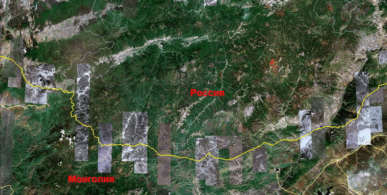
For example, in Buryatia and Zabaykalsky Krai a very small part of the surface was removed with good resolution, at the same time, 70-80% of sparsely populated areas of the border with Mongolia and China were shot with excellent quality! What for???
The border of Russia and Mongolia, deaf taiga, even border guards appear here very rarely:
')
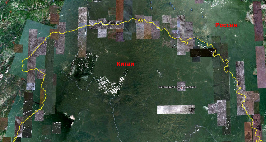
The Amur, along which the part of the border of Russia and China comes along, again the places are not so populated. Of course, there are a lot of people everywhere in China, but there is a clear interest in the border areas. Many of the pictures are dated this year, the rest of northern China is almost not updated:
It may be difficult to figure out what kind of decent person you need. Tourists, fishermen, hunters? Access to the border zone is usually prohibited. The frontier guards themselves? They are good if the light is there, not that the Internet ...
For example, here is the border region of the United States and Mexico:
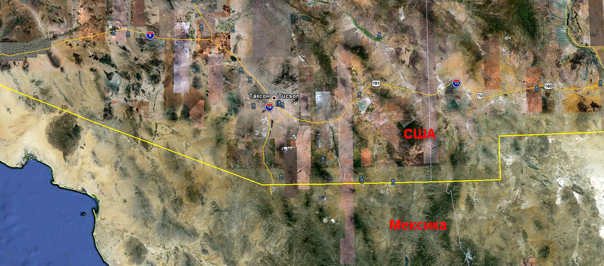
The border is visible quite well (just almost the whole continent is so filmed there), but, as is well seen, no one is in a hurry to update these pictures five years ago ... By the way, special services abroad cover up something , but for some reason we don’t hurry.
And here is our nuclear weapons repository, Belgorod-22, military unit 25624:

Another storage, Vologda-20, military unit 25594:

Please note that the areas of objects were shot separately in excellent quality, clearly marked precisely at this point. Nearby there are towns and villages, but Google Maps clearly captured only the SBS storage. And this is almost all strategic and military sites of Russia.
It can be assumed that the images are updated with Google statistics, the frequency of requests for a particular site, but among millions of users of the service, is the percentage of those who are interested in “nuclear cellars” and the borders of Russia are so great? By the way, if something is not in the Google Maps snapshots, quite often it can be clearly seen on Bing Maps.
It comes to the ridiculous, when a demob of military units paint a full location of troops on some Wikimapia, up to “a hole in the fence through which we went to self-will,” and the authorities of the unit cheerfully report on the observance of secrecy, shows to the inspectors beautiful signs shoot "and kilometers of barbed wire. There are entire communities (for example, here ) whose members understand the Russian military team as well as NATO experts, and this is only due to the study of satellite images and public information.
In the Middle East, terrorists have long been confronted with the use of satellite images from similar services; terrorist attacks in India have also been prepared using Google satellite images. Maybe it's time for our powers that be to switch from gay parades and "pigs" to protect the interests of the security of the homeland? Or will we wait for the first truck with explosives to ram the store of nuclear warheads? It is a pity that most likely it is a rhetorical question ...
UPD:
I do not propose to close the space to lock or shoot down satellites. Google removes the data on the appeal of the special services, who are not lazy to contact him ...
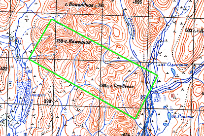
Apparently, in Russia, after all, there is a place completely hidden from prying eyes (painted over on the images of Google, Bing, Yahoo, Yandex, Kosmosnimki and Nasa). I would not be surprised if this is stupidly Abramovich's dacha ...
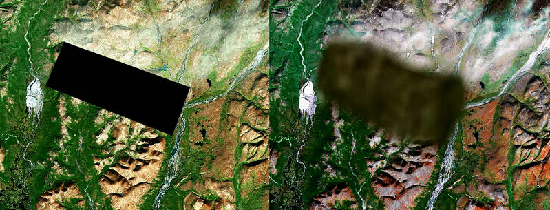
The area on the map of 1988, the state of the area on 1965-69 .:
For example, in Buryatia and Zabaykalsky Krai a very small part of the surface was removed with good resolution, at the same time, 70-80% of sparsely populated areas of the border with Mongolia and China were shot with excellent quality! What for???
The border of Russia and Mongolia, deaf taiga, even border guards appear here very rarely:
')
The Amur, along which the part of the border of Russia and China comes along, again the places are not so populated. Of course, there are a lot of people everywhere in China, but there is a clear interest in the border areas. Many of the pictures are dated this year, the rest of northern China is almost not updated:
It may be difficult to figure out what kind of decent person you need. Tourists, fishermen, hunters? Access to the border zone is usually prohibited. The frontier guards themselves? They are good if the light is there, not that the Internet ...
For example, here is the border region of the United States and Mexico:
The border is visible quite well (just almost the whole continent is so filmed there), but, as is well seen, no one is in a hurry to update these pictures five years ago ... By the way, special services abroad cover up something , but for some reason we don’t hurry.
And here is our nuclear weapons repository, Belgorod-22, military unit 25624:
Another storage, Vologda-20, military unit 25594:
Please note that the areas of objects were shot separately in excellent quality, clearly marked precisely at this point. Nearby there are towns and villages, but Google Maps clearly captured only the SBS storage. And this is almost all strategic and military sites of Russia.
It can be assumed that the images are updated with Google statistics, the frequency of requests for a particular site, but among millions of users of the service, is the percentage of those who are interested in “nuclear cellars” and the borders of Russia are so great? By the way, if something is not in the Google Maps snapshots, quite often it can be clearly seen on Bing Maps.
It comes to the ridiculous, when a demob of military units paint a full location of troops on some Wikimapia, up to “a hole in the fence through which we went to self-will,” and the authorities of the unit cheerfully report on the observance of secrecy, shows to the inspectors beautiful signs shoot "and kilometers of barbed wire. There are entire communities (for example, here ) whose members understand the Russian military team as well as NATO experts, and this is only due to the study of satellite images and public information.
In the Middle East, terrorists have long been confronted with the use of satellite images from similar services; terrorist attacks in India have also been prepared using Google satellite images. Maybe it's time for our powers that be to switch from gay parades and "pigs" to protect the interests of the security of the homeland? Or will we wait for the first truck with explosives to ram the store of nuclear warheads? It is a pity that most likely it is a rhetorical question ...
UPD:
I do not propose to close the space to lock or shoot down satellites. Google removes the data on the appeal of the special services, who are not lazy to contact him ...
Apparently, in Russia, after all, there is a place completely hidden from prying eyes (painted over on the images of Google, Bing, Yahoo, Yandex, Kosmosnimki and Nasa). I would not be surprised if this is stupidly Abramovich's dacha ...
The area on the map of 1988, the state of the area on 1965-69 .:
Source: https://habr.com/ru/post/106807/
All Articles