OpenStreetMap in universities. Why not?
 In this article we will discuss the foreign practice of using OpenStreetMap in universities, which would be great to learn.
For those who do not know: OpenStreetMap (OSM) is an open cartographic database of the whole world, which anyone can edit and which data is distributed under the free Creative Commons license ( CC-BY-SA 2.0 Generic ).
Last week I had a chance to visit the so-called Students Mapping Party, held in London at University College London (the university where Steve Cost , the creator of OpenStreetMap, once studied). This event was jointly organized by the local geomatics department and the volunteers from OpenStreetMap as the first practical lesson for students just starting to study in the magistracy.
')
The students got acquainted with the geographic information systems using the example of OSM and participated in drawing the map.
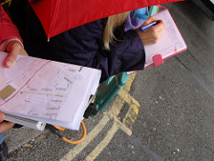
At first, students were given sheets of paper with a printed map of the area of land allocated to them ( walking papers ), and they went to bypass it, noting new objects on the printouts with a pencil. The next day, everyone gathered again and entered the data into the system together. All this was done under the guidance of teachers and OpenStreetMap members who wanted to come, so there was no shortage of help. In my opinion, for future cartographers, this is a very good way to “touch” the scope of activities they have chosen.
How was it going?
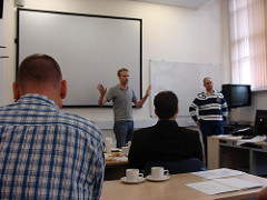 For those who are interested, I will tell you in detail about how the event was held.
On Wednesday, September 29, everyone gathered in the audience, where a small lecture was held on what OpenStreetMap is and how it gets data. The students were divided into groups of two or three people, and each group was assigned a plot of terrain, over which they should work (indicate unmarked shops, bars, addresses of houses, other objects). Were distributed walking papers - specially printed maps, over which it is convenient to draw new objects with a pencil. In the corner of such maps there is a QR code , which is used to bind a section of a map to a location after scanning. A scanned map can be used as a substrate (background image) in many OSM editors, which greatly simplifies data entry.
After the students were divided into groups, the openstreetmap participants who had arrived distributed brigades among themselves, and everyone left for their area (one of the districts of London just north of Regents Park).
 The process of data collection itself took about
 In the evening, after the "hard day of work" everyone met in a pub near the place they had just mapped.
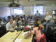 The next day, on Thursday, the students came to a computer audience, where they were given a small master class on how to add data to the OSM card, and how to use the Potlach editor. During editing, incoming OpenStreetMap participants answered students' questions and also gave all sorts of advice. After about 3 hours, all the work was done, and everyone went home.
Why is this useful?
To conduct such, in my opinion, great. OpenStreetMap for departments and faculties - an excellent training ground for training students; for future geoinformation specialists and geodesists - experience plus the opportunity to do something for a reason, and for the benefit of others; for society - a way to get a little more detailed free map of the whole world. OSM data can be used not only as a raster map on the site openstreetmap.org , but also, for example, in navigators, mobile phones and even commercial projects.
Unfortunately, in Russia everything is a little complicated by the need to have a license for cartographic activities, but since students are already allowed to walk around with theodolites in the city, why not then upload the results to the Internet?
Imagine how many hundreds of plans and maps drawn by students in class, thrown out or gathering dust in the archives. But this is so much work! The same can be said about tons of abstracts, term papers and diplomas, which, instead of becoming articles on the same Wikipedia, cease to exist after a cursory viewing of a single reader - a teacher.
I would be glad if something like that at least once will be held somewhere here. It will also be very cool if someone who has read this note has a desire to become the organizer of such an event, or to talk with his teacher.
By the way, if you don’t agree with the universities in your city, you can organize a mapping party just like this: get together, choose a district of the city, walk around and draw it, and then meet at a bar. In London, for example, such events are held about once every two weeks. In Russia, the last meeting of OSM participants was in Velikie Luki , and the next one is planned in St. Petersburg .
Links
- Event page, which was discussed at the OpenStreetMap wiki
- Photos of the event on Flickr (images with the caption “photo by Alex” can be easily copied anywhere if you wish and for anything, these are mine).
- List of meetings held in London over the past six months (marked area, photos, blog notes)
- List of upcoming OpenStreetMap meetings around the world
Source: https://habr.com/ru/post/105718/
All Articles